
Hiking in the Upper Las Virgenes Canyon Open Space Preserve in Calabasas
/
Trailhead at northern end of Las Virgenes Road in Calabasas
The Upper Las Virgenes Canyon Open Space is owned and maintained by the Mountains Recreation Conservation Authority. The 2,983 acres of open space was part of the Ahmanson Ranch in the Simi Hills of eastern Ventura County and western Los Angeles County, bordering the cities of Calabasas, Hidden Hills, West Hills, Bell Canyon, Simi Valley and Agoura Hills. The land, purchased in 2003, is contiguous with the existing 2,650 acres of open space in the Upper Las Virgenes Canyon.

This is a vast space of rolling hills, native perennial grasslands, oak trees and woodlands. Two plant communities, Southern Coast Live Oaks Riparian Forest and Southern Willow Scrub, make up over 20 miles of riparian corridors in the park.

The Victory Trailhead at the eastern end of Victory Boulevard is the main entrance into the Preserve, with a large gravel parking lot (there is a fee).
There are two main trailheads into the area. The Las Virgenes Canyon Road Trailhead is accessed at the northern terminus of Las Virgenes Road. Offstreet parking is available here; there is no official parking lot or facilities. The Victory Trailhead is the main trailhead for the preserve, located at the western terminus of Victory Boulevard in West Hills. There is a large gravel parking lot at the Victory Trailhead, where parking (as of February 2019) is $3.
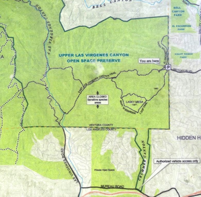
Excerpt of map posted at the Victory Trailhead
If you are looking for a hike of roughly 4 to 5 miles round trip, take the East Las Virgenes Canyon Trail that links the Las Virgenes Road and Victory trailheads. To explore more within the Preserve, check out the Lasky Mesa area southwest of the Victory Trailhead via the Mary Weisbrock Loop Trail. Or from the Las Virgenes Road trailhead, instead of heading east, continue north, where you can veer off into to the adjacent Cheeseboro Canyon area or find a loop that connects you back to the main trail. (See map for details.)

Peaceful and serene back here, albeit a bit dry.

While it can be quite dry during much of the year - particularly during times of drought - it sure greens up nicely after the winter rains (shown here in February 2019).
From a historical perspective, the Preserve was part of the 113,000 acre Rancho San Jose de Gracias de Simi tract granted to Javier, Miguel and Particio Pico by the King of Spain in 1795, later transferred to Jose de la Guerra y Noriega and sold in the late 1800s to Thomas R. Bard. Bard divided the Rancho into tracts to build homes.
The property was later owned by a William Randolph Hearst company, which unsuccessfully drilled for oil in the 1930s and later sold it to George E. Barrett, Jr. Barrett built a ranch here in the late 1930s. R. E. Crummer bought the property in 1949. H. F. Ahmanson Company bought the land in 1963 and failed in the 1960s in its attempt to develop the land.
In 1986, Ahmanson initiated a new attempt at a master-planned community centered atop Lasky Mesa and stretching across the surrounding hills and valleys. The Ventura County Board of Supervisors approved the project in 1992, but there were numerous opponents that ultimately led to the sale of the property to the Santa Monica Mountains Conservancy tin 2003. The public parkland was dedicated on April 10, 2004.
More information at mrca.ca.gov/parks/park-listing/upper-las-virgenes-canyon-open-space-preserve-formerly-ahmanson-ranch.

Another shot after lots of rain in February 2019.
