Ventura Pier

NOTE: The Ventura Pier was closed to the public in January 2023 due to significant storm damage. Repairs efforts have been underway with an estimated completion date of March 2024. Check for updates at www.cityofventura.ca.gov/2519/Ventura-Pier.

VenturaPier_1.jpg

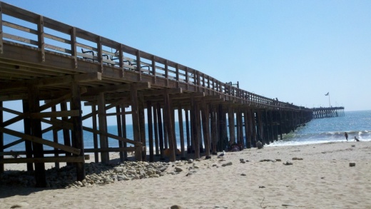
The Ventura Pier was originally constructed in 1872 and is a favorite spot for local fishermen. The Pier is 1,600 feet long and underwent a $2.2 million renovation in 2000 that added an 80 foot octagon shaped extension, benches and more. The Pier can be accessed off of East Harbor Boulevard, close to the Crowne Plaza hotel off of California Street.

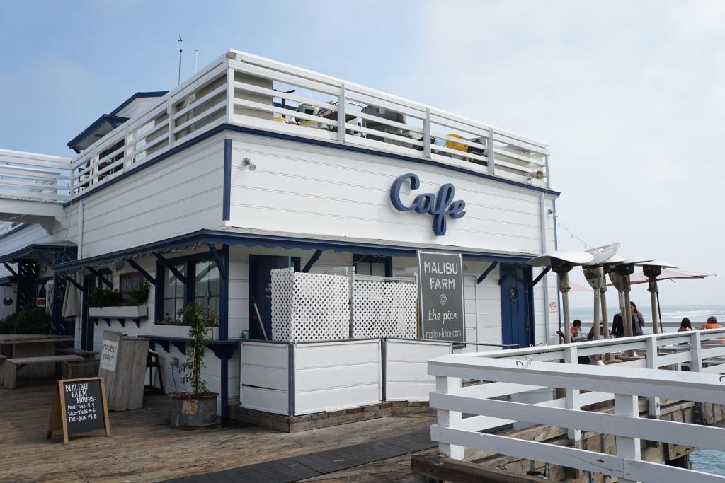
Eateries on the pier include Eric Ericsson’s Fish Co., MadeWest Brewing Company Taproom and Beach House Tacos.

VenturaPierSign.JPG

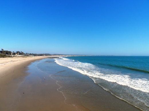
On the west side of the pier is a playground area with some unique play equipment. My kids always enjoy it here because of the great combination of the beach, pier, playground, quick access to bike rentals and food.

The Ventura Wharf (Pier) was designated City of Ventura Historic Landmark #20 on March 29, 1976.

The former Eric Ericsson's (now Beach House Fish) next to the playground on the pier.

The former Eric Ericsson's (now Beach House Fish) next to the playground on the pier.

VenturaPier_Underside.jpg
VenturaPierView.JPG

Ventura Harbor Village

VentHarborVillage2.jpg

Ventura Harbor Village at 1583 Spinnaker Drive, Ventura is home to 33 acres of harborside activities, shopping and restaurants.  The weather is always so cool over there it makes for a nice retreat.

Go for a walk along the boardwalk or at the beach or enjoy activities like kayaking, sailing, pedal boats, sport-fishing and cruises. Ventura Harbor Village hosts events and activities year-round, including music performances, kids' activities, themed events, festivals and more.

VentHarborVillage1.JPG
VentHarborVillage3.jpg

Eateries at Ventura Harbor Village include Andria's Seafood Restaurant, Baja Bay Surf N' Taco, Boatyard Pub, Brophy Bros. Clam Bar & Restaurant, Coastal Cone Ice Cream, Deep Sea Wine Tasting Room, Le Petit Cafe, Bakery & Restaurant, Margarita Villa Mexican Restaurant, On The Alley, Sugar Lab Bake Shop, The Greek Mediterranean Steak & Seafood and The Parlor. You won't go hungry here.

The Channel Islands National Park Visitor Center is located adjacent to Ventura Harbor Village. Free admission and an awesome resource for learning more about the Channel Islands and its protected habitat.

Island Packers at the Harbor has numerous boat rides and is the only authorized concessionaire to transport folks to Channel Islands National Park. 

Ventura Boat Rentals rents out electric boats, paddle boats, kayaks, power boats and charters cruises in the Ventura Harbor.  So much fun to be had!

VHarbor Kayaking.jpg

Across the street from Ventura Harbor Village is beach access at Harbor Cove Beach (a safe beach protected by jetties) and Surfer's Knoll Beach. Local area beaches at THIS LINK.

More information at www.venturaharborvillage.com or call 805.642.8538 (or 877.89.HARBOR).

Malibu Sportfishing Pier

The Malibu Sportfishing Pier is located at 23000 Pacific Coast Highway. Just north of the pier is Surfrider Beach and Malibu Lagoon State Beach. You can go sport fishing in a 48 foot boat or you can fish off the pier. 

The pier was originally built in 1905 and first became open to the public 1934. It is currently operated by the California Department of Parks and Recreation. The pier is open daily from 7 a.m. to 9 p.m., though the restaurants close later.

Malibu Farm Cafe opened at the ocean side of the pier in 2013, serving breakfast, lunch and dinner. (This was previously Ruby’s Shake Shack that closed in 2011.)

Malibu Farm Restaurant & Bar operates at the PCH side of the pier both indoors and outdoors. Open for breakfast (weekends only), lunch and dinner as well as weekend brunch.

To fish off the pier, either bring your own fishing gear or rent it from The Ranch at the Malibu Pier. at the end of the pier. Permits are not required to fish off of the pier. The Ranch rents fishing rods and sell bait, not to mention unique items such as ceramics, clothing, cards, skateboard and more.. Call 310.456.8031 for more information. Open 8 am to 8 pm daily. Learn more about The Ranch at the Pier at onegunranch.com/pages/pier.

Learn more about the Malibu Pier at www.parks.ca.gov/?page_id=24409 and at www.malibupiersportfishing.com.

Leo Carrillo State Park in Malibu

LeoCarilloSign.JPG

Leo Carrillo State Park consists of 1.5 miles of beach for swimming, surfing, windsurfing, surf fishing and beachcombing, as well as tide pools, coastal caves and reefs. Giant sycamores shade the main campgrounds.

Among the many great features of Leo Carrillo, the most engaging activity for me and the kids is the tide pools. They are exposed twice daily at low tide and provide hours of engagement with sea stars, sea anemones, mussels, sea slugs and more.

Nature walks and campfire programs are offered and a small visitor center has interpretive displays.

Trails include Yellow Hill Fire Trail for panoramic views of the beach and the Channel Islands, and the steeper Nicholas Flat Trail, which brings you to a pond.

There are 135 family campsites at Leo Carrillo with restrooms and token-operated showers. Visit ReserveCalifornia.com and search for “Leo Carrillo SP” to make reservations.

The park was named after Leo Carrillo (1880-1961), actor, preservationist and conservationist. Leo Carrillo served on the California Beach and Parks commission for 18 years and was instrumental in the state's acquisition of the Hearst property at San Simeon. Leo's greatest fame came from his portrayal of Pancho, the sidekick to Duncan Renaldo's Cisco Kid, an early 1950's TV series.

Leo Carrillo State Park is located at 35000 W. Pacific Coast Highway in Malibu. The park office phone is 310.457.8143. Visit www.parks.ca.gov/?page_id=616 for more information.

Parking is currently $12 in the parking lot for the day (or $3 per hour)...but free on PCH if you can find a spot. There are plenty of parking spots available in the lot. After you park, you can walk in a tunnel underneath PCH to get to the beach.

The muraled tunnel that takes you underneath PCH to Leo Carrillo Beach.

The muraled tunnel that takes you underneath PCH to Leo Carrillo Beach.

Dogs on a leash are allowed in the Park's day use areas, campground and north beach (north of lifeguard tower 3). Dogs are not allowed on backcountry trails or south beach (south of lifeguard tower 3).

DIRECTIONS

The most direct way of getting to Leo Carrillo from the Conejo Valley is via Westlake Boulevard (CA-23) (aka Decker Canyon) south, which for some is a fun 14 mile drive, but for others, not so much. It is a bit winding, hilly, steep at many junctures. I take this route during daytime hours but coming home I'm not too keen on it. After getting to PCH, turn right and drive 2 1/2 miles to get to Leo Carrillo.

Another more popular, though less direct route is via Kanan Road. Either take Kanan Road straight down to PCH, turn right (west) on PCH about 9 miles to Leo Carrillo, or take Kanan to Encinal Canyon, which is about a 3 mile drive on PCH to Leo Carrillo.

Lastly, if you are in Newbury Park, you can take Potrero Road west to Las Posas down to PCH. In about 11 miles you will reach Leo Carrillo.

Malibu Lagoon State Beach

Malibu Lagoon State Beach is where Malibu Creek meets the Pacific Ocean. To get there, park either at the state lot (corner of Pacific Coast Highway and Cross Creek Road) for a fee, along Pacific Coast Highway or across the street in spots available near Malibu Country Mart and the Malibu Civic Center.

The lagoon is serene, with a sandbar of pelicans enjoying their summer day. This beach extends southeast to Surfrider Beach and the Malibu Pier, which is just a short walk away. While you're there try to check out the Adamson House and Malibu Lagoon Museum.

More information at www.parks.ca.gov/?page_id=835. Dogs are not allowed at Malibu Lagoon State Beach and trails.

MalibuLagoon1.5.JPG
MalibuLagoon2.JPG
MalibuLagoon3.JPG
MalibuLagoon4.JPG

Beaches Spanning From Carpinteria Through Ventura County to Malibu

My kids and I love going to the beach but for many years we seemed to go to the same ones all the time. So I stopped by the Automobile Club and asked them if they had a brochure on all the local area beaches open to the public. They shrugged their shoulders and said no such guidebook existed. They handed me a fold out map, which was of no use to me as I wanted to know exactly how to get to these beaches, if they have restrooms, parking, etc.

MalibuBeach.jpg

Then I started searching around for information and found bits and pieces in various locations that were marginally useful. So I decided to consolidate this information into one place where I could find out about where to go to the beach around Ventura County on up the coast to Carpinteria and Santa Barbara and down to Malibu. So I hope you find the following links helpful in finding local area beaches in Ventura County and surrounding areas!

Carpinteria to Ventura

Oxnard to Malibu

Santa Barbara Area Beaches

This took a lot of time to compile over 60 local area beach areas, so I truly hope you benefit from these lists! So enjoy and provide feedback if you have comments and/or additional information.

MuguFisherman.jpg
At Leo Carrillo State Beach in Malibu.

At Leo Carrillo State Beach in Malibu.

Windsurfers at Surfers' Point in Ventura.

Windsurfers at Surfers' Point in Ventura.

Paradise Cove Beach in Malibu

If you’re looking for a great spot to dine at the beach, the Paradise Cove Beach Cafe in Malibu is a great choice. Located at 28128 E. Pacific Coast Highway in Malibu, it’s about a 30 minute drive from Thousand Oaks via Kanan Road. Learn more at www.paradisecovemalibu.com.

The public is welcome to access Paradise Cove Beach, including the dry stretch of beach around the pier (49 feet in width) as well as use the area of the beach below the mean high tide line for the entire shoreline length of the Paradise Cove property. You can either park on PCH and walk to the beach, or you can pay to park in the Cafe parking lot. But yes, it is expensive. It is much less expensive to park and dine at the cafe, which covers you for up to 4 hours of parking.

While some would argue that the food isn’t great and prices (including parking) is too high, my opinion is….it’s all about location, location, location.

About half a mile south on PCH is the access point to Escondido Falls, a four mile round trip hike to the tallest waterfall in the Santa Monica Mountains (over 150 feet). A fun excursion - park on PCH and do the Escondido Falls hike. Then walk down the street to the Paradise Cove Cafe. Of course don’t leave valuables in your car.

Parking fees as of June 2023.

County Line Beach in Solromar (Ventura County)

county line beach1.JPG

County Line Beach is located near the corner of PCH and Yerba Buena Road in Solromar, a small unincorporated community in the southwest corner of Ventura County, just northwest of the actual Ventura/Los Angeles county line.

The beach lies in between portions of the residential areas of Solromar. Solromar is the only residential community along the Malibu coast not included within Malibu city limits, yet this portion of Ventura County typically uses Malibu in its address. Neptune's Net is a well known eatery located across PCH from County Line Beach.

County Line Beach is a very popular surf spot and has about half a mile of sandy beach to enjoy. There is a dirt parking strip located off PCH that has spaces for about 15 cars; otherwise, street parking on PCH is available. There are a couple porta-johns. No lifeguards on duty here.

County Line Beach is referenced "Ventura County Line" in the 1963 Beach Boys hit, Surfin' U.S.A.

LOCAL BEACHES IN MALIBU, POINT MUGU, PORT HUENEME AND OXNARD

Stearns Wharf in Santa Barbara

Dolphins greet you at the entrance to Stearns Wharf.

Dolphins greet you at the entrance to Stearns Wharf.

StearnsWharf.gif

Stearns Wharf is located at the juncture of W. Cabrillo Road and State Street in Santa Barbara. Originally constructed in 1872 by lumberman John P. Stearns as the longest deep-water pier between Los Angeles and San Francisco, it is now one of the most visible and visited tourist destinations in Santa Barbara. In 1980-81, the City of Santa Barbara restored the wharf, constructed new buildings on it and assumed operation of the facility.

Our family particularly enjoys visiting the Museum of Santa Barbara Sea Center located on the wharf, followed by a stop at Mother Stearns Candy Company or the Great Pacific Ice Cream Company. Of course, The Harbor Restaurant and Longboard’s Grill are crowd favorites. There's also wine tasting at Deep Sea Wine Tasting Room, Moby Dick Restaurant, fish and chips, souvenir shops and other places.

View from the end of Stearns Wharf back toward the mainland.

View from the end of Stearns Wharf back toward the mainland.

View from Stearns Wharf

View from Stearns Wharf

You can get onto the wharf in a number of ways. There is limited parking on the wharf. Cost (as of May 2023) is $3/hour, but the first 90 minutes are free. Or you can park along Cabrillo Road or in a local beach parking lot and walk onto the wharf. Or do what we enjoy...park at the Santa Barbara Harbor and ride bikes onto the wharf. The wood planks are a bit bumpy but you'll survive!

Learn more about Stearns Wharf at www.stearnswharf.org.

Beautiful views of the harbor area as you'll see below from the pier. If you walk onto the wharf, you may encounter some locals that "live off the land" with sand sculptures and other monuments on the sand for your viewing pleasure (and perhaps some spare change). They are part of the carnival atmosphere. And of course on Sundays you'll be treated to the Santa Barbara Arts & Crafts Show that has been running since 1965.

Point Dume State Beach

On November 24, 1793, English explorer George Vancouver named the rocky promontory Point Dume after his friend, Father Francisco Dumetz. Point Dume is the western terminus of Santa Monica Bay and was named California Registered Historical Landmark No. 965.

PointDumeBeach.JPG

View in the spring of 2023

Point Dume State Beach is a 63 acre promontory that juts out into the Pacific and features headlands, cliffs, rocky coves and vast beach access for swimming, surfing and scuba diving.

To get to Point Dume State Beach, take Westward Beach Road southeast from PCH near Zuma Beach's south side to the paid parking area, or park on Westward Beach Road, which parallels Westward Beach.

To the southeast of Westward Beach is a small 300 foot or so beachfront area called Pirate's Cove Beach (which due to its seclusion was once used as a nude beach).

Pirate's Cove beach seen from the top of the promontory. You can climb down there and when the tide is moderate to low, walk around to it.

Pirate's Cove beach seen from the top of the promontory. You can climb down there and when the tide is moderate to low, walk around to it.

The 34-acre Point Dume Natural Preserve also begins from the cul-de-sac. A gradual ascending trail leads to an ancient coastal bluff sand dune with spectacular views...we've seen whales, seals and dolphins over here. A stairway from the east side of the bluff-top preserve allows access to a more isolated beach and tidepools (look but don't touch). You'll have fun exploring up here.

In the spring of 2023

This is a snippet of the pilot episode, "The Lady in the Bottle," of I Dream of Jeannie that originally aired September 18, 1965. If you skip to 1:39 in this clip, you will see the prominent rock formations on the east side of the Point Dume promontory. Below is a more recent shot of that area.

This is where Captain Anthony Nelson (Larry Hagman) made a giant S.O.S. in the sand with sticks and other items, including an old bottle that moved itself. He picks it up, dusts it off, and out pops Barbara Eden. Lucky guy!

This is where Captain Anthony Nelson (Larry Hagman) made a giant S.O.S. in the sand with sticks and other items, including an old bottle that moved itself. He picks it up, dusts it off, and out pops Barbara Eden. Lucky guy!

Location/Directions: Take Kanan south to PCH and turn right. Westward Beach Road is over the rise, at the foot of the hill. Park free on WBR or pay a fee at Westward Beach lot. No restrooms at the Preserve but some can be found on WBR. Call 310.457.8143 or visit www.parks.ca.gov/?page_id=623 for more information. Also see beaches.lacounty.gov/point-dume-beach.

Dogs are not allowed on trails in the Point Dume Natural Preserve or on the beach.

Westward Beach

Westward Beach

Springtime at the Point Dume Natural Preserve

Springtime at the Point Dume Natural Preserve

Thornhill Broome Campground in Point Mugu State Park

Thornhill Broome Family Campground is located at 9000 Pacific Coast Highway in Point Mugu State Park. The beachfront campground offers 68 tent/RV spaces. There are no hookups for RVs or flush toilets; just chemical toilets and cold outside showers. However, you are camping ON THE BEACH!

Thornhill camping.JPG

Sites have picnic tables and fire rings. Pets are allowed on leash in the campground. Fees as of August 2022 are $35/night plus a $7.99 reservation fee at www.reservecalifornia.com (type in Point Mugu SP to find Thornhill Broome). Be aware that summer months in particular book up way in advance.

Keep in mind that there is no shade when you camp at the beach. So if you don't have an RV, be sure to bring a canopy and/or umbrella.

Thornhill Broome Beach is across from the gigantic sand dune that provides for a great workout and views. And due east is Sycamore Cove and Sycamore Canyon Campground (both also in Point Mugu State Park)...which of course is the most direct path...albeit by foot or bike...to Newbury Park and the Conejo Valley from the beach.

And of course the Sycamore Canyon Campground is across from Sycamore Cove, if you're looking for additional camping possibilities.

Traveling southeast on PCH from Oxnard/Camarillo; this sign tells you you're just about there.

Traveling southeast on PCH from Oxnard/Camarillo; this sign tells you you're just about there.

The cool, massive sand dune across from Thornhill Broome Beach (be careful crossing PCH!).

The cool, massive sand dune across from Thornhill Broome Beach (be careful crossing PCH!).

Surfer's Knoll Beach in Ventura

Surfer's Knoll Beach is located in Ventura adjacent from Ventura Harbor Village and as its name implies, is geared towards surfers, as well as others looking to relax and explore. Riptides are common here so be careful if you're a novice swimmer. There are restrooms and showers available. Lifeguard service on weekends only in May until Memorial Day weekend, then daily through Labor Day weekend. There is a relatively small parking lot available at 1596 Spinnaker Drive; parking is free.

One great thing about this beach is that it is one of the few almost completely westbound facing beaches throughout the area, meaning...it is a great place to catch the sunset! And several of the Channel Islands - Anacapa and Santa Cruz.

Though this is a nice, sandy beach, a better beach for kids/families is just north up the road at Harbor Cove Beach, which is calmer water, protected by jetties. 

Surfer’s Knoll Beach, Harbor Cove Beach and South Beach is managed by the Ventura Port District at venturaharbor.com/beaches.

Sycamore Cove Beach in Point Mugu

sycamorecovesign.JPG

Sycamore Cove Beach is located at 9000 Pacific Coast Highway in Point Mugu. This beach is one of the closest and easiest to get to from the Conejo Valley and Camarillo via Las Posas and PCH.

Sycamore Cove Beach in the background. Sycamore Canyon Campground entrance on left.

Sycamore Cove Beach in the background. Sycamore Canyon Campground entrance on left.

The beach is popular with families looking to barbecue and enjoy quick and easy access to the beach. There are also porta-johns and restrooms available. Very limited parking on PCH (read the signs carefully as you don't want to get ticketed) but plenty of paid parking available (generally $12 to $14 for the day).

Dogs on a leash are allowed in day use areas, campgrounds and beaches within Point Mugu State Park. Dogs are not allowed on backcountry trails or dirt roads.

A view of Sycamore Cove Beach from the south.

A view of Sycamore Cove Beach from the south.

On the northwest end of the beach you can walk underneath PCH to the other side of PCH, where Sycamore Canyon Campground is located. From there, you can take Sycamore Canyon up to Newbury Park (about eight miles).

PCH is above. You can safely get from Sycamore Cove to Sycamore Canyon under this bridge (though at high tide can be a challenge). Beats risking your life crossing PCH!

PCH is above. You can safely get from Sycamore Cove to Sycamore Canyon under this bridge (though at high tide can be a challenge). Beats risking your life crossing PCH!

Due north of Sycamore Cove Beach is Thornhill Broome Beach/Campground, which along with Sycamore Cove and Sycamore Canyon is part of Point Mugu State Park. Across from Thornhill Broome is the large sand dune that makes for some fun climbing.

The humongous sand dune walking distance from Sycamore Cove.

The humongous sand dune walking distance from Sycamore Cove.

Visit www.parks.ca.gov/?page_id=630 for more information.