CSU Channel Islands University Park in Camarillo

CSU Channel Islands University Park is a 367 acre parcel located adjacent to CSU Channel Islands off of S. Lewis Road in Camarillo. It is a regional educational and recreation area owned and operated by California State University Channel Islands.

CSUCIPark_sign.JPG

The park is open to the public daily from sunrise to sunset. Do note that there are no facilities at this park, like restrooms and drinking fountains. You can walk, hike, run, bike, etc. and perhaps come across some wildlife.

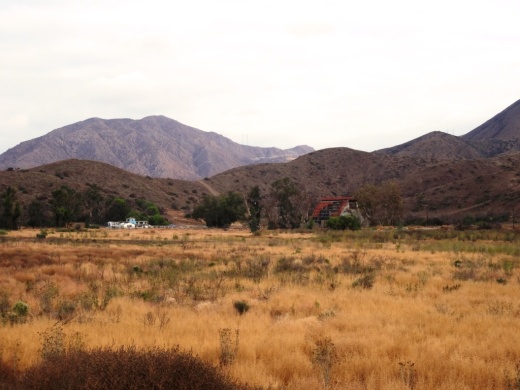
Disbanded dairy farm in the distance at CSU Channel Islands University Park

Disbanded dairy farm in the distance at CSU Channel Islands University Park

One item of historical interest at the park is the "Scary Dairy," a dairy farm located on the parcel that closed in the 1960s and was disbanded and subsequently vandalized and graffittied upon over the decades.

"Scary Dairy"

"Scary Dairy"

From Camarillo, take Lewis Road south to Camarillo Street and turn left (east).  Cross the bridge over Calleguas Creek and the entrance is on the left. Parking is $6 per vehicle (as of April 2019). Visit www.csuci.edu/cipark for more information.

Bring cash to pay for parking at entrance.

Bring cash to pay for parking at entrance.

CSUCI Park Barn.JPG

Los Padres Chapter of Sierra Club in Ventura and Santa Barbara Counties

Boney5.5.14.JPG

Founded in 1892,  the Sierra Club is the nation's largest and most influential grassroots environmental organization, with more than two million members and supporters.

The Los Padres Chapter of the Sierra Club serves California's Ventura and Santa Barbara counties. The Club encompasses everything from National Forest Wilderness areas of the San Ynez Mountains to the Channel Islands National Park in the Santa Barbara Channel.  

There are four groups in the Los Padres Chapter of the Sierra Club.  The Conejo Group and Ventura Network are based in Ventura County, while the Santa Barbara Group and Arguella Group (North County) are based in Santa Barbara County.

For upcoming Los Padres Chapter outings, visit www.sierraclub.org/los-padres.

For upcoming Conejo Group outings, visit www.sierraclub.org/los-padres/conejo.

For upcoming Ventura Sierra Club outings, visit www.sierraclub.org/los-padres/ventura.

And for Santa Barbara Group outings, visit www.sierraclub.org/los-padres/santa-barbara

General information about the Sierra Club at www.sierraclub.org.

Santa Barbara Zoo

sbzlogo.gif

The 30 acre Santa Barbara Zoo is a great family outing, with beautiful landscape, low key, clean environment and cool breezes from the nearby Pacific Ocean.

SBZooGiraffeSmall.jpg

There are over 500 animals at the Santa Barbara Zoo and my family's favorites include the giraffes and the penguins.  One of the most unique features is feeding the giraffes. For a fee of $8 (for an adult; $4 for kids) you are situated face to face with these friendly Masai giraffes as you give them a snack. Open weekdays from 11:30am to 1:30pm and weekends 11:30am to 12:45pm and 1:30-2:45pm.

The penguin exhibit is mesmerizing as you are treated to happy go lucky penguins frolicking in the water.

There are plenty of other animals, exhibits and places in the park to just hang out and have a picnic lunch.  And the train ride is always fun.

So drive the 45 miles up the coast, take the kids to the zoo, grab a bite, feel the sand, do some shopping and you've got yourself a nice day out.  Better yet, buy a tax-deductible zoo membership and visit the zoo several times per year with the kids.

Speaking of membership, if you have a membership at the Los Angeles Zoo, your card will get you 50% off admission at the Santa Barbara Zoo. Conversely, a membership at the Santa Barbara Zoo will get you 50% off at the Los Angeles Zoo. Nice!

The Santa Barbara Zoo is located at 500 Niños Drive, Santa Barbara.  For more information, visit www.sbzoo.org or call 805.962.5339 or 805.962.6310.

Open 9:30 a.m. - 5:00 p.m. Monday to Thursday, 9:30 a.m. to 7 p.m. Friday to Sunday, except 10:00 a.m. - 3:30 p.m. on Thanksgiving, Christmas Eve, and Christmas.

Ticket Prices (as of April 2021) are Adults 13-64: $19.95, Children 2-12 $11.95, Seniors 65+: $18.95 and Children under 2: Free. Parking: $11 (free with SB Zoo Membership)

Harmon Canyon Preserve in Ventura

Look for this address sign on Foothill Road to access the trailhead.

Look for this address sign on Foothill Road to access the trailhead.

Established in 2020, the Harmon Canyon Preserve is owned and managed by the Ventura Land Trust. The 2,100 acre preserve located at 7511 Foothill Road, Ventura (just west of Kimball Road) contains about 6 1/2 miles of well-maintained trails in the canyons and hills.

Open to hikers, bikers and runners. Dogs on leash allowed.

Free parking is available at the preserve trailhead off of McVittie Place. You can park on the west side of Kimball, or park a few blocks down Kimball and Loma Vista Road at Juanamaria Park, and walk a few blocks to the trailhead.

More details and trail map at www.venturalandtrust.org/harmoncanyon.

Trailhead

Trailhead

Old Jeep on the trail

Old Jeep on the trail

Harmon Canyon 3.JPG

Rocky Oaks Nature Reserve in the Malibu Hills

RockyOaks_sign.JPG

Rocky Oaks is a 250 acre nature reserve that is part of the Santa Monica Mountains Recreation Area, located at the 31500 block of Mulholland Highway in Malibu, west of Kanan Road. The entrance is on the north side of Mulholland Highway. The park is managed by the National Park Service.

RockyOaksLoopTrail.JPG

Rocky Oaks has various species of oak trees, some centuries old. The Overlook Trail takes you to a peak with gorgeous panoramic views while the Pond Trail (less than a mile round trip) takes you to a seasonal pond area which used to be part of a cattle ranch.

The Rocky Oaks Loop Trail is a 2.2 mile easy trail that is lined with sage. This is one of the more low key, easy to hike areas around town. It can get hot but at only 6 miles from PCH you can also feel some nice ocean breezes in these trails.

Learn more about Rocky Oaks and download a trail map at www.nps.gov/samo/planyourvisit/rockyoaks.htm.

Pond is looking quite nice in late spring of 2017.

Pond is looking quite nice in late spring of 2017.

RockyOaks_2.JPG

Los Robles Trail East in Thousand Oaks

The Los Robles Trail East in Thousand Oaks is accessible from the Los Robles Trail trailhead heading west from the corner of South Moorpark Road and Greenmeadow Avenue in Thousand Oaks.

LosRoblesTrail_SignMain.JPG

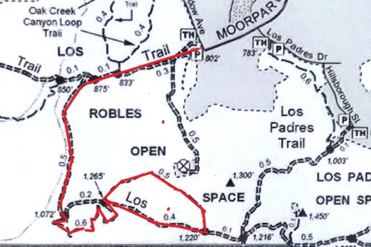
From the main trailhead, go west just under 1/2 mile and you'll see the fork in the road where you can go east or west. Head south (click here if you prefer going west) where you'll go towards the Los Robles Trail East.

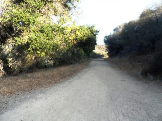
A gradual uphill of about 1/2 mile on a wide fire road trail takes you to a picnic bench and then a more winding, partially shaded, narrower, eastbound section of trail.

Fire road that takes you to picnic bench.

Fire road that takes you to picnic bench.

Picnic bench at juncture of fire road and narrower, steeper Los Robles Trail East.

Picnic bench at juncture of fire road and narrower, steeper Los Robles Trail East.

LosRoblesTrail_MapEast.jpg

Another .6 mile gets you to a hill where you'll soon be treated to a reward for your hiking effort...a bench with a view of the Conejo Valley.

Los Robles Trail East near hilltop viewpoint with bench.

Los Robles Trail East near hilltop viewpoint with bench.

And the bench at the top. Nice view of the Conejo Valley, eh?

And the bench at the top. Nice view of the Conejo Valley, eh?

And the trail loops around with another bench on the other side of the trail looking south towards Hidden Valley.

Bench facing south.

Bench facing south.

The trail loops back around towards the main Los Robles Trail, where you can head back west again from where you came from, or head east towards the northern tip of the Los Padres Trail or stretch further east towards the Triunfo Canyon Trail and White Horse Canyon Trail.

Now go on, take a hike!

Los Padres Trail in Thousand Oaks

LosPadresTrail_trailhead.JPG

The Los Padres Trail is a short, 1 mile, neat little trail accessed on Los Padres Drive, near the corner of Fox Hills Drive in Thousand Oaks. Take Moorpark Road south of the 101 freeway and turn left on Los Padres Drive. The trailhead is clearly marked on the right hand side, The trail is maintained by the Conejo Open Space Foundation.

Surrounded by trees in the first section of the Los Padres Trail.

Surrounded by trees in the first section of the Los Padres Trail.

Short but sweet, the trail is.canopied by trees, several bridges, mostly single track trail and a bit of a climb (750 feet) as you make your way up to the Los Robles Trail junction. That's about a mile, so you can turn around there for a 2 mile round trip hike.

Where the Los Padres Trail meets the Los Robles Trail.

Where the Los Padres Trail meets the Los Robles Trail.

Or...you can turn right (west) and head your way up the wide, fire road sized section of the Los Robles Trail east. This is a bit of a climb, but pretty moderate and gradual. Crest the hill and you'll see a gate. Before the gate, on the left, is a picnic bench.

The Los Padres Trail is winding, uphill and wide in this section.

The Los Padres Trail is winding, uphill and wide in this section.

After you pass the sign below, there's a picnic bench on the left. You've climbed a couple miles. Time for a break before heading back down. Or turn left (east) and in 3 miles you're at Triunfo Park in the Los Padres Open Space via the Triunfo Canyon Trail. Or turn right (west) and you're off into the Los Robles Open Space. If you go straight ahead, you’ll reach a gate to Hidden Valley private property.

LosRoblesTrail_Triunfo.JPG
Gate at top of trail. Private property in Hidden Valley ahead.

Gate at top of trail. Private property in Hidden Valley ahead.

Marview Drive Trail in Thousand Oaks

Marview Drive Trail Trailhead in Thousand Oaks

Marview Drive Trail Trailhead in Thousand Oaks

If you're looking for a short, steep and sweet trail to hike up and down in Thousand Oaks, check out the trail on Marview Drive, just east of the entrance to Old Meadows Park at 1600 Marview Drive. Take Erbes Road and go west on Marview. After passing the residential section of the road, up ahead is Old Meadows Park and on the right is plenty of street parking across from the trailhead.

MarviewTrail_steep.jpg

Short it definitely is. Only about a quarter of a mile to the top of the hill, but it will take you a bit longer than your typical hike because it is so steep, at least the first section.

MarviewTrail.JPG

Then toward the top it starts to flatten out, where you will discover panoramic views of the Conejo Valley. There's also quite a clear view of the 23 Freeway from up here!

Marview_23fwy.JPG

At the top of the trail is a large, enclosed square fenced in with No Trespassing signs all over the place. This is a water tank. But you can walk around the area to the other side, where there's actually a trail and walkway that goes down to the St. Patrick’s Episcopal Church.

So there you have it! A short, steep, but sweet little trail in the heart of Thousand Oaks!

Ventura Botanical Gardens Demonstration Trail

There is now an admission price of $7 per person Tues through Sun from 9am to 5pm. Kids are free. Fridays are free. Closed Mondays. Annual memberships are also available, which allow for unlimited free admission; $45 per person, $75 for families.

Additionally, dogs are allowed on Wednesdays and Fridays only and must be on leash.

Trails are intact but the plants were devastated by the Thomas Fire. Replanting and re-growth is in process.

Trails are intact but the plants were devastated by the Thomas Fire. Replanting and re-growth is in process.

The Ventura Botanical Gardens Demonstration Trail is a nearly 1 mile trail between Ventura City Hall and Grant Park. It opened in October 2012. The trail zig zags and meanders its way up to Grant Park, offering awesome views of downtown Ventura and the coastline. The trail is accessible behind Ventura City Hall, located at 567 South Poli Street. Take the driveway on the right side of City Hall (facing the building) and drive up to the parking area.

Funds continue to be raised to enhance the Demonstration Trail, provide for trail maintenance and augment it with a new trail and ultimately build a visitor center. Learn more at www.venturabotanicalgardens.com.

Access to the trail is on the right (east) side of Ventura City Hall.

Access to the trail is on the right (east) side of Ventura City Hall.

There's a parking area at the bottom of the trail behind Ventura City Hall

There's a parking area at the bottom of the trail behind Ventura City Hall

The trail is decorated with pretty wildflowers and other California native plants

The trail is decorated with pretty wildflowers and other California native plants

There are some neat rock walls on sections of the trail

There are some neat rock walls on sections of the trail

A short walk will get you some pretty views!

A short walk will get you some pretty views!

GrantParkTrailViews2.JPG

Santa Rosa Trail and Lower Butte Trail in Thousand Oaks

SantaRosaTrail.JPG

The Santa Rosa Trail connects Wildwood Park to the hills above Cal Lutheran University in Thousand Oaks, about a 3 mile hike one way along the Mount Clef Ridge. Enjoy beautiful views of the Conejo Valley and Santa Rosa Valley, then loop around the hills behind CLU.

SRTrail_toWildwood.JPG

From Wildwood Park, you can take the Mesa Trail west and turn right onto the Santa Rosa Trail. Or start from the other direction...park at CLU near the Samuelson Community Pool and hike towards Wildwood.

Juncture of Santa Rosa Trail and Lower Butte Trail.

Juncture of Santa Rosa Trail and Lower Butte Trail.

Or take an alternate route with the Lower Butte Trail. The Conejo Open Space Foundation website has a map of the Santa Rosa/Lower Butte Trail loop hike that is about 6 miles in length from Wildwood Park at cosf.org/trails/wildwood/wildwood-park-moderate-hike-santa-rosa-lower-butte-loop.

Two benches and a cross abpve CLU, east of the CLU sign, with panoramic views of the Conejo and Santa Rosa Valleys.

Two benches and a cross abpve CLU, east of the CLU sign, with panoramic views of the Conejo and Santa Rosa Valleys.

SRTrail_SRViews.JPG

Ranch Center Road, Wood Canyon Fire Road and Other Trails in Northern Point Mugu State Park

Northern Point Mugu State Park map image courtesy National Park Service

Northern Point Mugu State Park map image courtesy National Park Service

Point Mugu State Park in the Santa Monica Mountains stretches from Newbury Park to the ocean, over 14,000 acres of land and 70 miles of trails. Visit this link for more information.

If you ever get the time and energy, consider exploring the trails in the northernmost section of Point Mugu State Park. To access these trails, you can start at Rancho Sierra Vista/Satwiwa in Newbury Park and make your way up Big Sycamore Canyon Road, then, down, down, down the big paved hill into the canyons of Point Mugu State Park.

The descent down into the canyon on Big Sycamore Canyon Road is pretty steep. Watch for cyclists. Boney Mountain is seen in the distance.

The descent down into the canyon on Big Sycamore Canyon Road is pretty steep. Watch for cyclists. Boney Mountain is seen in the distance.

The descent into the canyon is about 3/4 mile. From there, you'll go another mile or so until you see a fork in the road. If you go straight (veering slightly left), you'll continue down Big Sycamore Canyon Road towards PCH. But if you turn right, you're on Ranch Center Road, a gradual, steady climb up an old, paved hill.

Juncture of Big Sycamore Canyon Road (left) and Ranch Center Road (right).

Juncture of Big Sycamore Canyon Road (left) and Ranch Center Road (right).

This is one section of Ranch Center Road. As you can see, this is a pretty old road that was used by the ranchers who lived here before the land was acquired by California State Parks.

This is one section of Ranch Center Road. As you can see, this is a pretty old road that was used by the ranchers who lived here before the land was acquired by California State Parks.

You are highly unlikely to see a lot of people down here. You might see a couple cyclists from time to time, but hikers/runners in these quiet areas are, from my experience, pretty rare in appearance. It feels like you're going to the middle of nowhere.

You will also notice that there are several trails that connect with the road, including, from east to west, the Sin Nombre Trail, Sage Trail, Ranch Center Fire Trail, Coyote Trail and, finally, the Wood Canyon Fire Road trail. All of these trails will either take you back to Big Sycamore Canyon Road or other trails that will allow you to do a loop back up to Rancho Sierra Vista. You can add another 4 miles to your adventure by checking out the Guadalasca Trail that connects to the Wood Canyon Fire Road. See detailed map here.

Old water tank seen at the juncture of Ranch Center Road (paved) and Ranch Center Fire Road (trail).

Old water tank seen at the juncture of Ranch Center Road (paved) and Ranch Center Fire Road (trail).

After you pass the water tank seen above, you continue downhill towards the remains of some old ranch houses. Pretty much everything has been demolished but you'll see some vintage items still on hand, along with signs warning you to stay outta there.

You've reached what used to be the Ranch Center.

You've reached what used to be the Ranch Center.

Not sure if this would sell on Craigslist.

Not sure if this would sell on Craigslist.

The old ranch house area is at the juncture of Ranch Center Road and Wood Canyon Fire Road. I particularly enjoying running down Wood Canyon Fire Road as it is so quiet and there is nice tree coverage.

More Wood Canyon Fire Road

More Wood Canyon Fire Road

Wood Canyon Fire Road runs south until it connects with the "Loop Trail" (west) or continues east back towards the Two Foxes Trail (parallels Big Sycamore Canyon Road) and then Big Sycamore Canyon Road, where you can veer back up north towards Newbury Park. 

DOZENS AND DOZENS OF TRAILS IN AND AROUND VENTURA COUNTY

Heritage Park Native Plant Demonstration Garden in Thousand Oaks

The Heritage Park Native Plant Demonstration Garden is located at the corner of Thousand Oaks Boulevard and Long Court in Thousand Oaks (next to the still vacant Corrigan's Steak House and across from Pacific Breeze Salon). The garden was designed by the Conejo Valley Audubon Society in collaboration with the City of Thousand Oaks. The drought-resistant California native plants seen in the garden attract birds, butterflies, pollinators by providing food and shelter while eliminating the need for fertilizer and pesticides.

More information at wp.conejovalleyaudubon.org/wp-content/uploads/2020/07/HeritagePark_Palette_FINAL-amended11-24-16.pdf.

Malibu Lagoon Field Trips Hosted by Santa Monica Bay Audubon Society

The Santa Monica Bay Audubon Society (SMBAS) hosts Malibu Lagoon Field Trips the 4th Sunday of every month.

Adult Walk starts at 8:30 a.m. for 2-3 hrs. The group meets at the metal-shaded viewing area next to parking lot. SMBAS makes a special effort to make these monthly Malibu Lagoon walks attractive to first-time and beginner birdwatchers. Brings binoculars and cameras.

Metal shaded viewing area next to parking lot.

Metal shaded viewing area next to parking lot.

Children & Parents Walk starts at 10:00 a.m. for a 1 hr session. Meet at metal-shaded viewing area next to parking lot. SMBAS leaders are experienced with kids so by all means bring them down to the beach to enjoy nature. Binoculars will be provided.

Upcoming dates: 9/27/20. (SUBJECT TO CHANGE DUE TO COVID - PRIOR MONTHS HAVE BEEN CANCELLED)

If you have a Scout troop or other group 7 or larger, please call Lu at 310.395.6235 to make sure SMBAS has enough binoculars and docents on hand.

Visit smbasblog.com to learn more.

Directions: Malibu Lagoon is located at the intersection of Pacific Coast Highway and Cross Creek Road in Malibu. Bring water and sun protection; look around for people wearing binoculars and hats.

Parking: Self-serve parking machine in lot, $3/hr, $12 day ($11 seniors); credit cards accepted. Annual passes accepted. You may also park (read all signs carefully) on PCH west of Cross Creek Road, on Cross Creek Road, or on Civic Center.Way north (inland) of the shopping center. Lagoon parking in shopping center lots is not permitted.