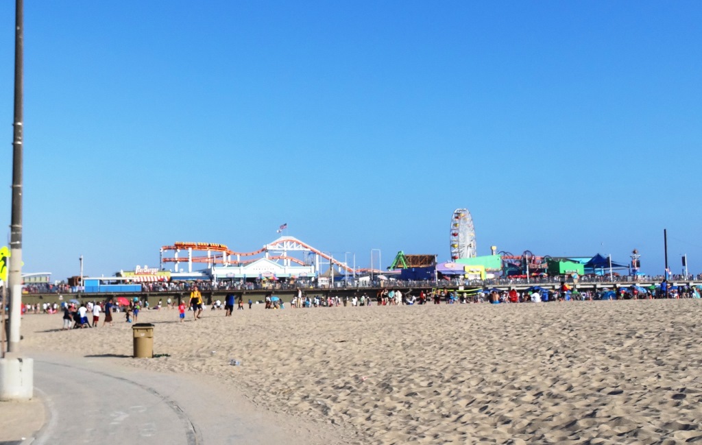
San Buenaventura State Beach in Ventura

San Buenaventura State Beach is a two-mile stretch of beach from the Ventura Pier on the north down south past the homes of the Ventura Keys to just north of Marina Park on the south.

This beach features swimming, surfing and picnicking. There are two miles of sandy beach, sand dunes, picnic sites, a parking lot, restrooms and the Jolly Oyster. San Buenaventura State Beach features the largest day-use picnic area at a state beach in Southern California.

Looking to ride a bike but didn’t bring one? Rent one near the pier at Wheel Fun Rentals.

There’s a nice mile-long hike and bike trail along the beach stretching from the park entrance at San Pedro Street and Pierpoint Blvd to the Ventura Pier. This trail continues northward up the boardwalk past Surfers’ Point and beyond. CLICK HERE for more details on the Omer Rains Trail.

The 1,700-foot pier has a snack bar, Beach House Fish restaurant and bait shop. Wheel Fun Rentals is right near the pier if you need a bike. Visit www.parks.ca.gov/?page_id=600 or call 805.585.1850. Campfires not allowed at this beach.

Plenty of parking available for a fee, accessible at San Pedro Street and Pierpont Boulevard in Ventura, as well as additional parking with direct access to the Ventura Pier at 1156 E. Harbor Boulevard.

Grant Park / Serra Cross Park in Ventura

SerraCrossPark1.JPG

For some of the most spectacular views of Ventura you can ask for, stop by Grant Park / Serra Cross Park off of Ferro Drive in Ventura. Grant Park is a 107 acre park of mostly open space. Serra Cross Park is located at Grant Park. It is a one acre parcel that contains the wooden cross shown below.

The land and cross were sold to San Buenaventura Heritage, Inc. in 2003 in order to maintain the historic cross, which was placed on this spot in 1941 to replace the previous cross that was erected in 1912.

Visit www.serracrosspark.org to learn more about Serra Cross Park.

Get there via Brakey Road to the left side of Ventura City Hall or Ferro Drive off of Cedar Street. There are no restrooms, playground, drinking fountains, etc. at this park.

SerraCrossPark2.JPG
SerraCrossPark3.JPG
SerraCrossPark4.JPG
SerraCrossPark5.JPG
SerraCrossPark8.JPG

Vista Del Mar Trail in Newbury Park

Trail access off of Via Ricardo in Newbury Park (Dos Vientos section).

Trail access off of Via Ricardo in Newbury Park (Dos Vientos section).

Other end of trailhead off of Via Ricardo.

Other end of trailhead off of Via Ricardo.

The Vista Del Mar Trail is a 1 to 1 1/2 mile long trail along the west side of the Dos Vientos residential development in Newbury Park. The trail is maintained by the Conejo Open Space Foundation.

The trail can be accessed near the corner of Via Ricardo and Via Rincon (parking on Via Ricardo). The other end of the trail is near the corner of Rancho Dos Vientos and Via El Cerro (where there is no parking on Rancho Dos Vientos).

"Vista Del Mar" is Spanish for "View of the Sea" and while the overcast early morning photos below do not show it, on a clear day you will indeed be able to see down the Potrero Grade to the Pacific Ocean and Channel Islands. The Vista Del Mar trail also provides views to Camarillo and the Oxnard Plain.

The trail is nice and wide, good for walkers, runners and cyclists.

The trail is nice and wide, good for walkers, runners and cyclists.

The north section of the trail before intersecting with the Edison Fire Road Trail is where the "Twin Ponds" are. The image below of one of the ponds was taken after the Springs Fire of May 2013 ravaged the area. More on the Twin Ponds Conservation Area at this link.

DosVientos5.5.13_12.JPG

The Twin Ponds are more easily accessed via the northeast Vista Del Mar trailhead near the corner of Via Ricardo and Via Rincon. About a mile.

VistaDelMar_priprsign.JPG
VistaDelMarTrail_priprpsign2.JPG

About 1/4 mile into the trailhead from Via Ricardo, you'll reach this junction. Veer right to the single track public access trail, as the trail to the left is on private property.

Lone bench on the Vista Del Mol trail that has views to the Channel Islands on a clear day

Lone bench on the Vista Del Mol trail that has views to the Channel Islands on a clear day

The Vista Del Mar trail connects on the southeast to the Sierra Vista Trail, which in turn connects to the Potrero Ridge trail, with an endpoint on Reino Road.

Views from the Vista Del Mar Trail on a clear morning.

Views from the Vista Del Mar Trail on a clear morning.

Map courtesy of the Conejo Open Space Foundation

Map courtesy of the Conejo Open Space Foundation

Marvin Braude Coastal Bike Path - Pacific Palisades to Torrance

We love driving down to Will Rogers State Beach from time to time, bring the bikes and enjoy the Marvin Braude Coastal Bicycle Path along the Pacific Ocean. 

This fun 22 mile path takes you from Pacific Palisades as far as Torrance.  Depending on how far you want to go and if you have kids with you, there are so many spots to stop along the way. 

To get to Will Rogers State Beach from the Conejo Valley, take the 101 to Las Virgenes/Malibu Canyon Road south to PCH, then about 9 miles down PCH to Will Rogers (17000 PCH), just east of Gladstones and Sunset Boulevard. Parking at Will Rogers varies based on when you go; I last recall paying $10.

The path doesn't actually start at Will Rogers Beach as it is a walking path only at this point. Ride the bike through the parking lot to the start of the bike path at Temescal Canyon Road. And, you're off!

From the start of the path, here are some approximate distances to destinations:

  • Santa Monica Pier - 3.2 miles
  • Venice Pier - 5.8 miles
  • Marina del Rey - 8.7 miles
  • Playa del Rey - 9.9 miles
  • Dockweiler Beach - 12.5 miles
  • Manhattan Beach Pier - 16.5 miles
  • Hermosa Beach Pier - 18.2 miles
  • Redondo Beach Pier - 20.4 miles
  • Torrance Beach - 22.3 miles (endpoint)

With younger kids, the Santa Monica Pier makes a perfect 6 1/2 mile round trip destination as you can stop, eat lunch and have some fun at Pacific Park, then ride back. Or kick it a few notches and ride to/through Venice Beach for all the action. 

Pacific Park up ahead

Pacific Park up ahead

There are plenty of restrooms water stops and of course non-stop BEACH to enjoy here, making this one of my favorite destination for bicycling with the family. And of course, you don't have to park at Will Rogers...you can park anywhere on PCH in and around the bike path to enjoy it.

Of course you do have to be careful of sand on the path, pedestrians/beach goers crossing and walking on the path, other cyclists, runners, roller bladers and crowds.  

Detailed map at file.lacounty.gov/SDSInter/dbh/docs/189949_2013-BIKEMAP85x11Web-Ready(highres).pdf

CLICK HERE FOR DOZENS OF FAMILY-FRIENDLY BIKE PATHS BACK UP IN THE VENTURA COUNTY AREA!

Ojai Library Ukulele Club

The Ojai Library Ukulele Club meets every Wednesday from 6 to 7 p.m. in the main library building. The Ukulele Club is about sharing the fun, simplicity, and musicality that the ukulele offers, and learning and practicing with other players. Continuously meeting since its formation in 2015, the club is open to all ages and levels of experience. If you have your own ukulele, bring it along! Alternatively, the club has a couple of extra ukuleles for drop-in guests to try out for the evening.

Feel free to bring a copy of a song or tune that you like; the club collects these in a book of songs used during meetings. Currently this collection includes classic ukulele standards, American folk music, contemporary selections, and more. Each songbook includes a chord chart and is easy to follow—each song has the accompanying chords and lyrics listed and ready to play!

These events are free and open to the public. For additional information, contact Ron Solórzano, Regional Librarian, at (805) 218-9146.

The Ojai Library is located at 111 East Ojai Avenue in Ojai. Hours of service are 10 a.m. to 8 p.m. Monday through Thursday and 12 p.m. to 5 p.m. Friday through Sunday.

The Ventura County Library is available 24/7 at www.vencolibrary.org.

Heritage Square Oxnard - Historic Tours

HeritageSquare.png

Visit Heritage Square in Oxnard for an information-filled tour of the historic structures of Heritage Square and learn more about Oxnard. Docent led tours are $5, $10 for a family of four. Every Saturday 10AM - 4PM and every Sunday 1PM - 4PM, weather permitting. School and group tours available by appointment. The tours are approximately 45 minutes long and include 3 interiors and 8 exteriors of the 15 structures on this block. Tours start at the Heritage Square Visitor Center at 715 South A Street, next to the water tower.

More information at www.heritagesquareoxnard.com or call 805.483.7960.

Santa Barbara Historical Museum

SantaBarbaraHistoricalMuseum.jpg

Founded in 1932, the Santa Barbara Historical Museum houses a collection of over 80,000 objects and artifacts of significance relating to Santa Barbara’s past. Constructed in 1965 by the Santa Barbara Historical Society, the Museum is the primary repository of Santa Barbara’s collective cultural heritage and ethnic diversity. Visitor see a wide array of unique paintings, objects, photographs, furnishings and textiles dating from the 15th century. Santa Barbara’s rich past is represented with artifacts from Chumash, Spanish, Mexican, “Yankee” and Chinese cultures. The Museum also hosts three to four special exhibitions a year in the rotating Sala gallery.

The Gledhill Library contains rare literary and visual documents, including 70,000 historic photographs. Two early 19th century buildings, the 1817 Casa Covarrubias and the 1836 Historic Adobe are adjacent to the Museum.

The Fernald Mansion, a fourteen room Queen Anne Victorian located at 414 West Montecito Street, is currently closed for renovation.

Admission is free, $5 donation suggested. The Museum is open Tuesday to Saturday from 10am-5pm, Sunday 12-5pm, and is closed Mondays. Free guided tours on Saturdays and Sundays at 2pm.

The Museum is located at 136 E. De la Guerra Street, on the corner of Santa Barbara St. and De la Guerra. Visit www.SantaBarbaraMuseum.com or call 805.966.1601 to learn more.

Serra Retreat in Malibu

The Serra Center sign as seen from Pacific Coast Highway

The Serra Center sign as seen from Pacific Coast Highway

The Serra Retreat is a Catholic retreat and conference center located in the hills of Malibu on a 26 acre knoll, across the street from the Malibu shoreline. The location, since 1943, has welcomed church groups, schools, non-profits and other organizations a quite space for retreats and workshops.

Courtyard area facing the Pacific Ocean

Courtyard area facing the Pacific Ocean

During the week, the public is allowed to visit the grounds between 9 am and 4:30pm for personal prayer and reflection. No reservations are required. You must stop at the guard gate, located on Serra Road at PCH, about a 1/4 mile east of Cross Creek Road, obtain a guest pass, then slowly drive up Serra Road, for about a mile until you seen the turnoff on to the Retreat on the left. The actual address of the facility is 3401 Serra Road, Malibu.

Parking pass received at guard gate

Parking pass received at guard gate

There are no public restrooms at the facility and dogs are not allowed, nor or picnic lunches. This is a place for reflection, not to mention taking in the great views. There are a number of benches to reflect as you look down below as you enjoy paths and walkways and enjoy the gardens and sights. There is also a stone lined labyrinth for walking and reflection. 

Labyrinths are always cool, both to look at and to walk.

Labyrinths are always cool, both to look at and to walk.

You can get married here too, with two locations to celebrate after the ceremony. Capacity is 120 guests.

Learn more at serraretreat.com.

The view is not too shabby either!