Ojai Trolley Service

Ojai Trolley

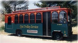
The City of Ojai has run the Ojai Trolley Service since 1989.

There are two routes - routes A and B, each with 10 stops, most overlapping. Route A services out to Gridley Road, including Whispering Oaks. Route B services the Ojai Valley Inn. All other nine stops on the two routes are the same, starting from Ojai Avenue at the Arcade.

It costs $1.50 to ride the trolley (as of January 2024) or $4 for a day pass. Reduced ($.75/$2) and free fares available for children under 45”, seniors 75+ and disabled with proper ID.

The trolley runs 7 days a week,  every day of the year except Easter, Memorial Day, July 4th, Labor Day, Thanksgiving Day, Christmas Day, and New Year's Day.

Hours vary. Route A service starts at 6:36 am on weekdays and 7:06 am on weekends. Route B service starts at 7:06 am on weekdays and 8:06 am on weekends.

For more information and detailed route schedules, visit www.ojaitrolley.com.

OjaiTrolleyPic.JPG

The Nethercutt Museum in Sylmar

Nethercutt1.JPG

The Nethercutt Museum in Sylmar houses a spectacular collection of over 120 antique, vintage, black iron and classic automobiles. This is a place that a surprisingly few number people know about but is a must see. It is a truly gorgeous collection of cars, including numerous winners of the Pebble Beach Concours d’Elegance and other famed auto shows.

Nethercutt2.jpg

Particularly eye opening to an auto novice like me is the sheer number of different car manufacturers on display that I'd never heard of, like Tucker, Simplex, Cord, REO, Maybah, Ruxton, Westinghouse, Pierce-Arrow, Moon etc as well as autos made by Daimler, Rolls Royce, Cadillac, Packard, Lincoln, Ford, Duesenberg, Oldsmobile, Bugatti and others. There is also huge number of hood ornaments, headlamps and other vintage paraphernalia on display.

Nethercutt3.JPG
Nethercutt4.jpg

Admission to The Nethercutt Museum is free of charge and hours are 9 a.m. to 4:30 p.m. Thursday through Saturday. Visit www.nethercuttcollection.org for more information. Open to all ages.

Nethercutt5.JPG

Located at 15151 Bledsoe Steet, Sylmar. When I went I took the 101 east to the 405 south towards Santa Clarita, which becomes the 5 freeway. Get off at Roxford exit east (exit 159A; don't get confused and take the NEXT Roxford exit). Turn right on Roxford, right on San Fernando Road and left on Bledsoe. Museum is a few blocks up on the left hand side. Turn left on Bradley (at Bledsoe) and an immediate left into the parking lot.

Nethercutt6.JPG

Outside the Museum you can walk through a 1912 Pullman Rail Car and a 1937 Canadian Pacific Royal Hudson Locomotive. Open twice a day (weather permitting) at 12:30 p.m. and 3:45 p.m. for 15 minutes.

In addition to the main Museum, next door at 15200 Bledsoe is The Nethercutt Collection, which has over 50 automobiles along with what they call the world's finest assemblage of mechanical musical instruments. Admission here is also free but you must make reservations for the 2 hour docent-led tour, kids must be 12 and older, and no video recording or flash photography is allowed. Tours are currently offered at 10 a.m. and 1:30 p.m. Thursday through Saturday.

Nethercutt7.JPG
Nethercutt8.JPG
Nethercutt9.JPG

U.S. Navy Seabee Museum - NBVC Port Hueneme

U.S. Navy Seabee Museum - NBVC Port Hueneme

The U.S. Navy Seabee Museum is one of the Navy's eleven official museums. Its mission is to select, collect, preserve, and display historical material relating to the history of the Naval Construction Force, better known as the Seabees, and the U.S. Navy Civil Engineer Corps.

The second oldest of the official Navy museums, the Seabee Museum was established in 1947 in Port Hueneme, which today is part of Naval Base Ventura County.

The Seabee Museum was recently renovated and is quite a beautiful, state-of-art facility. The 38,000 square foot museum features modern exhibit spaces, memorial garden, theater, education room

Read More

Ventura Harbor Village

VentHarborVillage2.jpg

Ventura Harbor Village at 1583 Spinnaker Drive, Ventura is home to 33 acres of harborside activities, shopping and restaurants.  The weather is always so cool over there it makes for a nice retreat.

Go for a walk along the boardwalk or at the beach or enjoy activities like kayaking, sailing, pedal boats, sport-fishing and cruises. Ventura Harbor Village hosts events and activities year-round, including music performances, kids' activities, themed events, festivals and more.

VentHarborVillage1.JPG
VentHarborVillage3.jpg

Eateries at Ventura Harbor Village include Andria's Seafood Restaurant, Baja Bay Surf N' Taco, Boatyard Pub, Brophy Bros. Clam Bar & Restaurant, Coastal Cone Ice Cream, Deep Sea Wine Tasting Room, Le Petit Cafe, Bakery & Restaurant, Margarita Villa Mexican Restaurant, On The Alley, Sugar Lab Bake Shop, The Greek Mediterranean Steak & Seafood and The Parlor. You won't go hungry here.

The Channel Islands National Park Visitor Center is located adjacent to Ventura Harbor Village. Free admission and an awesome resource for learning more about the Channel Islands and its protected habitat.

Island Packers at the Harbor has numerous boat rides and is the only authorized concessionaire to transport folks to Channel Islands National Park. 

Ventura Boat Rentals rents out electric boats, paddle boats, kayaks, power boats and charters cruises in the Ventura Harbor.  So much fun to be had!

VHarbor Kayaking.jpg

Across the street from Ventura Harbor Village is beach access at Harbor Cove Beach (a safe beach protected by jetties) and Surfer's Knoll Beach. Local area beaches at THIS LINK.

More information at www.venturaharborvillage.com or call 805.642.8538 (or 877.89.HARBOR).

Santa Clara River Valley Railroad Historical Society's Railroad Visitor Center in Fillmore

SCRVRailroad_logo.gif

The Santa Clara River Valley Railroad Historical Society was established in 1993 to help preserve and restore the railroad corridor between Montalvo and Saugus. This corridor, known as the Southern Pacific Santa Paula Branch, is a unique and historical local community asset.

Stop by the Railroad Visitor Center, located at 455 Main Street, Fillmore, on Sundays between noon and 3 p.m. (or by appointment) and check out historical artifacts, information and photographs, a large model train setup, gift shop, theater and more.

More information at www.scrvrhs.com or call 805.524.2254.

We stopped by the Sespe Creek Car Show at Fillmore & Western yesterday (4th of July) and while we were there walked into the Santa Clara River Valley Railroad Historical Society Railroad Visitor Center at 455 Main Street, Fillmore. We've been in here several times before with the model trains all running and the kids sit there mesmerized by them.

Spring Canyon Trail Hike in Thousand Oaks

The Spring Canyon Trail is a short, fairly easy hike in the Newbury Park/Thousand Oaks section of the Los Robles Trail system that is great family fun.

Although a good portion of the Spring Canyon Trail is flat like this, there definitely are some moderately hilly sections.

Although a good portion of the Spring Canyon Trail is flat like this, there definitely are some moderately hilly sections.

This one mile trail runs east from the vicinity of Lynn Oaks Park, 359 Capitan Street, Newbury Park as well from the eastern terminus of Hemlock Lane, at Heavenly Valley Road in Newbury Park (in the Ventu Park community) to a juncture where you can either continue straight ahead for about a half a mile towards the Los Robles Trail access point at South Moorpark Road and Greenmeadow Avenue in Thousand Oaks or veer up "Space Mountain" on the right. (The views at the top of Space Mountain are awesome but this is a bit of a climb and is very popular with mountain bikers...probably not the best direction with little ones).

The path that takes you from Lynn Oaks Park to the Spring Canyon Trail.

The path that takes you from Lynn Oaks Park to the Spring Canyon Trail.

Sign above Lynn Oaks Park that tells you that to the left is Los Robles Trail and to the right is the Hemlock Lane gate in Ventu Park.

Sign above Lynn Oaks Park that tells you that to the left is Los Robles Trail and to the right is the Hemlock Lane gate in Ventu Park.

Out and back you can make this a 2 to 3 mile moderate hike or more if you add in the Oak Creek Canyon Loop or Los Robles Nature Walk.

Sign at the east terminus of Spring Canyon Trail indicating Moorpark Road is half a mile away. Behind me is the trail toward "Space Mountain" and Los Robles Trail going east towards Newbury Park.

Sign at the east terminus of Spring Canyon Trail indicating Moorpark Road is half a mile away. Behind me is the trail toward "Space Mountain" and Los Robles Trail going east towards Newbury Park.

You can also park your car at the Moorpark Road/Greenmeadow trailhead and make your way west towards the Spring Canyon Trail and perhaps eat lunch or snack at Lynn Oaks Park (which by the way also has a nice playground area, basketball court and more...but no restroom however).

Paramount Ranch Recreation Area in Agoura

The Woolsey Fire in November 2018 destroyed the historic structures at Paramount Ranch described below. However, there is a plan to rebuild four of the structures in 2023-2024. More information at www.nps.gov/samo/learn/historyculture/paramount-past-present-and-future.htm.

ParamountRanchWoolsey.JPG
Paramount Ranch Western Town Aerial View (Courtesy NPS)

Paramount Ranch Western Town Aerial View (Courtesy NPS)

Paramount Ranch is located in Agoura off of Cornell Road, between Kanan Road and Mulholland.  Click here for a map in a pdf file on the National Park Service website.

Paramount Pictures originally purchased 2,700 acres here for use as a "movie ranch" in 1927 and since then, hundreds of movies and TV shows have been filmed there.  A permanent western town was built on the site in the early 1950s using old Paramount Pictures props.  Before the Woolsey Fire of 2018, you could walk freely around these old sets.

Before the Woolsey Fire of November 2018.

Before the Woolsey Fire of November 2018.

The Western Town sign and bridge is still there but most everything surrounding it is burnt after the Woolsey Fire of November 2018.

The Western Town sign and bridge is still there but most everything surrounding it is burnt after the Woolsey Fire of November 2018.

ParamountRanchPic1.JPG
Western Town at Paramount Ranch destroyed in the Woolsey Fire.

Western Town at Paramount Ranch destroyed in the Woolsey Fire.

ParamountRanch2.JPG
A beacon of hope. Two structures were unharmed in the Woolsey Fire - this church building seen in the TV series “Westworld” and the train station.

A beacon of hope. Two structures were unharmed in the Woolsey Fire - this church building seen in the TV series “Westworld” and the train station.

ParamountRanch3.JPG

A list of movies filmed at Paramount Ranch is here.  These include films like The Last Outlaw (Gary Cooper), The Virginian (Gary Cooper), Tom Sawyer, Huckleberry Finn (Jackie Coogan), Million Dollar Legs (W.C. Fields), Adventures of Marco Polo, Remember  the Night (Barbara Stanwyck) and many more.  From 1992 to 1997, the TV show, Dr. Quinn, Medicine Woman (featuring Jane Seymour) was filmed there.

Beyond the western town, there are plenty of hiking trails at the park.  More information at www.nps.gov/samo/planyourvisit/paramountranch.htm or call the NPS at 805.370.2301.

Malibu Sportfishing Pier

The Malibu Sportfishing Pier is located at 23000 Pacific Coast Highway. Just north of the pier is Surfrider Beach and Malibu Lagoon State Beach. You can go sport fishing in a 48 foot boat or you can fish off the pier. 

The pier was originally built in 1905 and first became open to the public 1934. It is currently operated by the California Department of Parks and Recreation. The pier is open daily from 7 a.m. to 9 p.m., though the restaurants close later.

Malibu Farm Cafe opened at the ocean side of the pier in 2013, serving breakfast, lunch and dinner. (This was previously Ruby’s Shake Shack that closed in 2011.)

Malibu Farm Restaurant & Bar operates at the PCH side of the pier both indoors and outdoors. Open for breakfast (weekends only), lunch and dinner as well as weekend brunch.

To fish off the pier, either bring your own fishing gear or rent it from The Ranch at the Malibu Pier. at the end of the pier. Permits are not required to fish off of the pier. The Ranch rents fishing rods and sell bait, not to mention unique items such as ceramics, clothing, cards, skateboard and more.. Call 310.456.8031 for more information. Open 8 am to 8 pm daily. Learn more about The Ranch at the Pier at onegunranch.com/pages/pier.

Learn more about the Malibu Pier at www.parks.ca.gov/?page_id=24409 and at www.malibupiersportfishing.com.

Sunset Hills Trail in Thousand Oaks

SunsetHillsTrail_sign.JPG

The Sunset Hills Trail is easily accessible off of Erbes Road in Thousand Oaks, just 7/10ths of a mile north of Sunset Hills Boulevard, just past Fernleaf Court.

There's a triangular dirt parking lot on the east.

There's a triangular dirt parking lot on the east.

This is a pretty easy mile or so trail that takes you past the Bard Lake Reservoir. The reservoir is of course is fenced in but you'll be treated to its beauty as you make your way up. Lake Bard is owned by the Calleguas Water District for storage of up to 10,000 acre-feet (3.3 billion gallons) of water used to meet peak summer demand and emergency requirements.

SunsetHillsTrail2.JPG

In fact, most all the way up this fairly gentle, hilly slope, you'll get some great panoramic views of the entire area, including the Conejo Valley, Simi Hills and looking west towards Camarillo/Oxnard. Continue east and you will reach the Woodridge Open Space in Thousand Oaks.

SunsetHillsTrail1.JPG
SunsetHillsTrail4.JPG

The Sunset Hills Trail is maintained by the Conejo Open Space Foundation. More information at cosf.org/trails/other-trails/easy-hike-sunset-hills-trail.

SunsetHillsTrail5.JPG

An additional, and perhaps more popular hike provides even better view of the Bard Reservoir. Take the additional loop in the shape of Maine (kind of) either clockwise or from the first juncture or counterclockwise after cresting the hill. If you go to the top of the hill take the trail on the left and continue onwards. You will see some steps and a bench to take in the views along the way.

(Map courtesy of the conejo Open Space Foundation) Green highlighted section is a nice loop to hike - good family hike.

After cresting the first hill from Erbes Road, find the loop trail on the left.

After cresting the first hill from Erbes Road, find the loop trail on the left.

A short walk to this bench that overlooks Bard Reservoir.

A short walk to this bench that overlooks Bard Reservoir.

Continue on the trail until it loops around and goes south., parallel to Highway 23

Continue on the trail until it loops around and goes south., parallel to Highway 23

Soon you will be back at the main trail, passing through this tree-tunneled section.

Soon you will be back at the main trail, passing through this tree-tunneled section.

Historic Dudley House Museum in Ventura

San Buenaventura Heritage, Inc. (SBH) is a non-profit educational and charitable organization founded in 1978 with a primary focus of preserving the Dudley House, an 1892 Victorian farm house, located at 197 N. Ashwood, Ventura. The Dudley House is one of 35 Ventura County properties listed in the National Register of Historic Places.

DudleyHouse.JPG

The house is a living history museum reflecting the life of the Dudley family. The terraces and pergola for outdoor events have been installed on the north side side of the house, and the lavender garden with some 100 plants featuring over 20 varieties is on the south side of the house. The basement is used as a community room and visitor center with cooking facilities and is available for small events and receptions. Larger events can be held outside on the grounds.

The Dudley House is open for tours the first Sunday of the month from 1pm to 4pm from January to November.

Visit dudleyhouse.org or call 805.644.3286 for more information.  Admission is free but donations are accepted and appreciated.

Dudley House Boutique 2023

Open November 24-26 and December 2, 3, 9, 10 from 11 a.m. to 5 p.m. with a flea market added on Sundays from 8 a.m. to 4 p.m. Find quality crafts, home decor, antiques and collectibles.

Historic Recording Series

During open houses, pre-1930 recordings transferred to CDs are played. A new recording is played each month on the Victrola console in the parlor.

Old Time Radio Series

CDs of radio shows are performed in the radio console on the 2nd floor hallway.

Triunfo Canyon Trail in Westlake Village

TriunfoCanyon_sign.JPG

If you are looking for peaceful trails and outstanding panoramic views of the Conejo Valley from Thousand Oaks to Westlake Village, Hidden Valley and beyond, take a look at the Triunfo Canyon Trail, accessible from Triunfo Community Park, Triunfo Canyon Road at Tamarack Street in Westlake Village.

TriunfoCanyon1.JPG

The trailhead is on the northwest end of the park, near the tennis courts. It is a beautiful, winding, single track canyon trail for most of the first mile or so, then links up to the main Los Robles Trail and utility road, which is much wider.

Views of the Westlake Lake area from the Triunfo Canyon Trail.

Views of the Westlake Lake area from the Triunfo Canyon Trail.

You'll discover some steps to a bench at the top offering a birds eye view of the surrounding areas. It really is spectacular up there and the images here don't come close to doing the view justice.

Bench at the top of the hill allows you to catch your breath and take in the sights.

Bench at the top of the hill allows you to catch your breath and take in the sights.

From the bench, either turn around and go back down the hill or continue your way on if you'd like to the Los Robles Trail, above the Los Padres Trail.

One thing I'll say about these trails is that they seem particularly rocky, so wear decent shoes, as you don't want to twist your ankle. A bit of a climb to get up there; about 1,000 feet.

Learn more about the trail on the Conejo Open Space Foundation website at cosf.org/trails/los-robles/los-robles-moderate-hike-triunfo-park-to-east-los-robles-trail.

TriunfoCanyon6.JPG

Janss Marketplace in Thousand Oaks

Janss Marketplace in Thousand Oaks

Janss Marketplace at 275 North Moorpark Road in Thousand Oaks (corner of Moorpark Road and Hillcrest) is an open air mall that has a large outdoor eating area, interactive water fountain, monthly Kids Fun Zone and outdoor kids play area.

Retailers and other businesses at Janss Marketplace include Gold's Gym, Ulta Beauty, Old Navy, Nordstrom Rack, DSW Shoe Warehouse, Aldi, Five Below, Petco and others.

Eateries include Buca di Beppo, Panera Bread, Karma Indian Cuisine, Crazy King Kong Sushi, Lucky's Dog House, Sunset Terrace Restaurant, Greco's New York Pizzeria, Cold Stone Creamery, Sharky's, Matcha Tea and Boba, Janchi Korean BBQ, California Fish Grill, Eureka Brewing Company, Starbucks, Wingstop, O’t Bistro and Pieology.

And for entertainment, there’s Regal Cinemas, Defy Extreme Sports, Dave & Buster’s and The Mighty Axe.

There are plans for a 5-story, 216 room Homewood Suites & Home2 Suites hotel on the property that includes 13,000 sq ft of retail space. Pending zoning approvals for a 75 foot height, construction is anticipated to begin in the spring of 2024, with a target opening date of winter 2025.

For more information visit www.janssmarketplace.net or call 805.495.4662.

In 2009 the Janss Marketplace added a NEOS Wall, a fun interactive game right outside the Golds Gym.  This game is free. 

Some former occupants of Janss Marketplace: Toys R Us (summer 2018) Wachovia Banking Center (closed April 2011), Akio’s Sushi (Oct 2012; now Crazy King Kong Sushi), Sizzler/Fuddruckers/Hooters (currently vacant), TGI Fridays (2012)/DISH (Nov 2013) (now Janchi), Aaron Brothers (2018), Tuesday Morning (June 2012), Radio Shack, Marshalls, Mervyn’s, Mann 9 Theatres/Regency Theatres (now Regal Cinemas), Burger King/Salad Gourmet (2016)/Poke Tiki (Apr 2019). Subway (August 2019)., The Dudes' Brewing Company (March 2020). Burlington Coat Factory (July 2021) and Naru Bento (June 2022).

Janss Marketplace History

  • Originated in the 1960s as the Conejo Village Shopping Center. Also referred to as “The Mall.”

  • Changed its name to Janss Mall in August 1978. This came four months after The Oaks mall opened in Thousand Oaks. A key reason for the name change was to distinguish the “old” mall from the new mall.

  • Changed its name to Janss Marketplace in 1995, when it added the Mann 9 Theatres, Mervyns, Linens N’ Things, Best Products and other businesses.

Janss Mall sign in Thousand Oaks News Chronicle - November 12, 1978

Conejo Creek Bike Path in Thousand Oaks

Conejo Creek Bike Path (Courtesy City of Thousand Oaks)

Conejo Creek Bike Path (Courtesy City of Thousand Oaks)

The Conejo Creek Bike Path is a 1.2 mile path in Thousand Oaks that connects Gainsborough Road on the south to Conejo Creek Park South. From there, you can cross Janss Road to get to the Thousand Oaks Library Conejo Creek Park North and the Thousand Oaks Teen Center

This path opened to the public in Spring 2011, providing a nice, flat alternative to city streets as it goes under State Route 23.

The paved path on Paige Lane ends at Janss Road across the street from the Thousand Oaks Library, but you can take the crosswalk at Janss Road at the crosswalk and from there get to a wide, fairly flat horse trail that takes you up to Avenida De Los Flores.

The east end of Gainsborough Road has an access point to the Conejo Creek Bike Path

The east end of Gainsborough Road has an access point to the Conejo Creek Bike Path

Nice flat path adjacent to city streets and neighborhoods

Nice flat path adjacent to city streets and neighborhoods

The path takes you under the 23 Freeway

The path takes you under the 23 Freeway

The path ends at Janss Road, across from the Thousand Oaks Library Conejo Creek Park North.

The path ends at Janss Road, across from the Thousand Oaks Library Conejo Creek Park North.

The City of Thousand Oaks maintains approximately 80 miles of bikeways, including about 3 miles of bike paths, roughly 54 miles of bike lanes and another 20 miles or so of bike routes.