
Try the Strenuous Fossil Trail Loop in Point Mugu State Park for a Weekend Challenge
/If you have two to three hours to spare and are looking to do about six miles of strenuous local hiking, consider trying the Fossil Trail loop in Point Mugu State Park, starting at the adjacent Rancho Sierra Vista/Satwiwa managed by the National Park Service in Newbury Park. If you're looking for a FLAT hike, this one isn't for you! (But do check out these other great local trails.)
Find your way to the main parking lot at Via Goleta off of Lynn Road (or alternatively park at the Wendy/Potrero Trailhead for an extra few miles of hiking). From there, hike towards the Satwiwa Native American Indian Culture Center.

You can stop and visit the Center on weekends from 9 am to 5 pm. But to get to the Fossil Trail, take the paved Sycamore Canyon Fire Road towards Point Mugu State Park.

Sycamore Canyon Fire Road approaching entry into Point Mugu State Park
In a short while, you'll reach the end of the relatively flat section of your trek, as you look down into Sycamore Canyon.

Looking down into Sycamore Canyon

Another view of where you'll be going...down, down, down into Sycamore Canyon

When you reach this bridge at the bottom (with porta potty up ahead), you'll be making a left hand turn to the Upper Sycamore Canyon Trail. If you veer right, that'll take you all the way down to the Pacific Ocean...another great hike, run or cycling experience!

Here is the Upper Sycamore Canyon Trail sign on the left.
Just 1/10th of mile is the Fossil Trail trailhead on the right. It was not marked the last time I did this trek but it should be pretty apparent.

Here's what the Fossil Trail trailhead looked like in mid-July 2015.
The Fossil Trail is less than a mile but is quite steep. Not for the faint of heart.

Views looking down after a bit of trekking up the Fossil Trail.
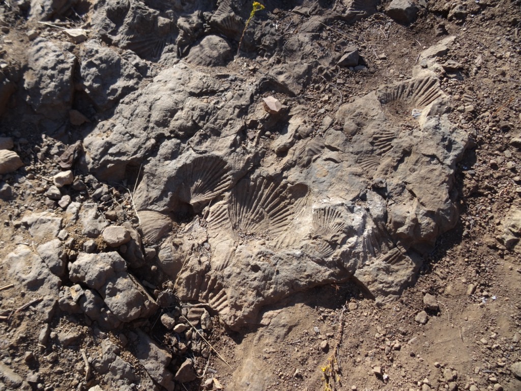
You don't see any fossils until you get about two thirds or so of the way up the trail, unless I just never look hard enough. But suddenly you notice them right on the trail. Evidence that this was underwater at some ancient point in time. Pretty cool.
And soon after admiring those fossils (and sorry to say there aren't THAT many of them in view but they're still cool to see), you'll reach Old Boney Trail, where you'll be making a left turn (turning right goes off toward the Blue Canyon Trail, further down into Sycamore Canyon).

The Old Boney Trail is also fairly steep in most sections as it traverses a 1.4 mile path towards Danielson Road in the Boney Mountain Wilderness. Steep and rocky in sections, so be sure to wear good footwear!

This portion of our trek has the most extensive array of views, from the Channel Islands, Oxnard Plain, Conejo Valley, Hidden Valley and of course, Boney Mountain.

One of many great views from the Old Boney Trail
You will reach the crest of the trail, and there's actually an unmarked pathway at the top that gets you on a direct path towards Boney Mountain. But let's move on.

You get some nice "up close" views of Boney Peak from the Old Boney Trail.
After a decent downhill (which by the way, from time to time I've seen deer hanging out up here along with the frequently seen lizards). you'll reach Danielson Road.

Danielson Monument is only a .3 mile detour to the right. Learn more at this link. But we will now turn left for mostly downhill jaunt down Danielson Road.

Danielson Road is flat at first but after this stretch a nice, solid downhill to the bottom.
You'll finally make it to the bottom of the hill, where you will be making a left run to reach civilization once again. But at this juncture you can also go right first to check out the "Waterfall" (which unfortunately in recent drought years has been barely more than a trickle in winter months).

So when you reach the Danielson Road trail sign after passing through what is actually a creek when we're not in a severe drought, you have about .4 mile of hiking back up the trail to reach the Satwiwa Loop Trail. On your way, you'll come across the bench at the Upper Sycamore Canyon Overlook.

pretty dry looking out there in the summer, particular in a severe drought!
Just a few steps down from the bench, you'll reach your the Satwiwa Loop Trail and your final decision point. Do you go left, straight, or right? The path straight head takes you on a diagonal passing directly back to the Satwiwa Center. But both the left and right paths also will get you back there. So your call.
Now that you're done, it's time for a cold drink!
