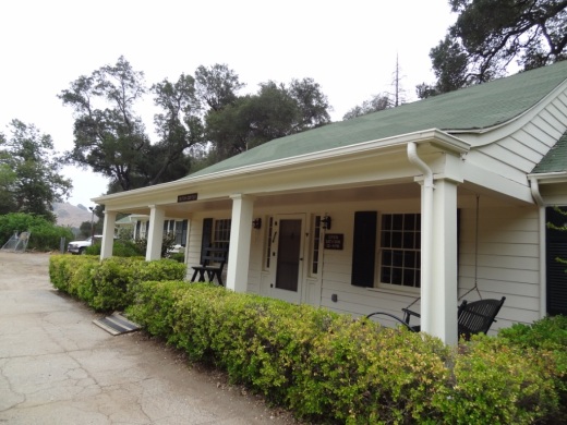
State Fish Hatchery in Fillmore

The California Department of Fish and Game maintains a Fish Hatchery in Fillmore, off Highway 126, just east of downtown Fillmore. Watch for the sign - you make a quick right on Fish Hatchery Road, not more than a mile or so from downtown Fillmore. (The given address is 612 E. Telegraph Road, but Fish Hatchery Road is just east of there.)

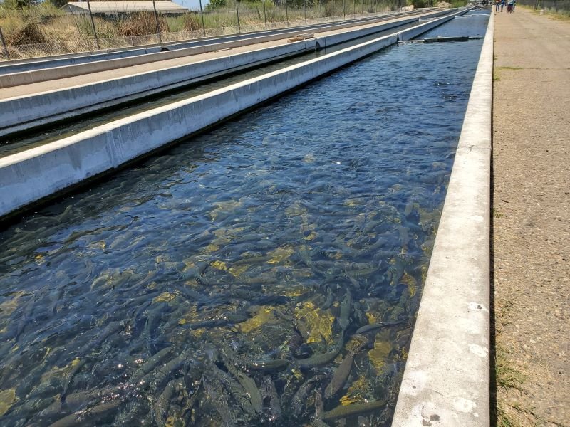
Fish species raised at the Fillmore Hatchery include rainbow trout and brown trout. The hatchery is located in a former citrus grove bordering the Santa Clara River. It was originally constructed in 1942 with 30 earthen ponds that were supplied by spring and well water. Major renovations were made in 1968 and 1972 that included the construction of 40 concrete ponds, with water temperatures averaging 60 degrees. Fish are raised for one year before release for recreational angling. An average of 700,000 trout are released annually into lakes and streams primarily in Southern California.

The hatchery is open 365 days a year, from 8 a.m. to 2 p.m. Bring dimes to purchase fish food and learn about fish and their role in California. This is a self-guided tour. More information at www.wildlife.ca.gov/Fishing/Hatcheries/Fillmore.

Ventura Pier

VenturaPier_1.jpg

The Ventura Pier was originally constructed in 1872 and is a favorite spot for local fishermen. The Pier is 1,600 feet long and underwent a $2.2 million renovation in 2000 that added an 80 foot octagon shaped extension, benches and more. The Pier can be accessed off of East Harbor Boulevard, close to the Crowne Plaza hotel off of California Street.

Eateries on the pier include Eric Ericsson’s Fish Co., MadeWest Brewing Company Taproom and Beach House Tacos.

VenturaPierSign.JPG

On the west side of the pier is a playground area with some unique play equipment. My kids always enjoy it here because of the great combination of the beach, pier, playground, quick access to bike rentals and food.

The Ventura Wharf (Pier) was designated City of Ventura Historic Landmark #20 on March 29, 1976.

The former Eric Ericsson's (now Beach House Fish) next to the playground on the pier.

The former Eric Ericsson's (now Beach House Fish) next to the playground on the pier.

VenturaPier_Underside.jpg
VenturaPierView.JPG

Arroyo Burro Beach Park in Santa Barbara

ArroyoBurro_sign.JPG

Arroyo Burro Beach is a beach park managed by the County of Santa Barbara. It is also referred to as Hendry's Beach, as the Boathouse at Hendry's Beach is located here at 2981 Cliff Drive. Decent sized parking lot with restaurant serving up moderately priced meals and drinks indoors/outdoors, seven days a week from 7:30am to 9:30pm. Arroyo Burro Beach is a sandy beach, good for surfing, boogie boarding and fishing, with an adjoining park with grassy areas with picnic tables. Restrooms available. From the 101 take Las Positas Road south to Cliff Drive. Turn right and travel 1/2 mile to the park entrance. More information at www.countyofsb.org/810/Arroyo-Burro-Beach

ArroyoBurro1.JPG
ArroyoBurro_Hendrys.JPG

Arroyo Burro also has a great doggie park! Dogs are required to be on leash through the parking lot but there's an area where dogs can run around in the ocean. Self service dog wash stations provided by County Park.

Next to Arroyo Burro is the Douglas Family Preserve, an open space area donated to the City of Santa Barbara in 1997. The space contains walking trails, ocean views and offers off-leash beach fun for the doggies! sbparksandrec.santabarbaraca.gov/parks/douglas-family-preserve

ArroyoBurro2.JPG

Malibu Sportfishing Pier

The Malibu Sportfishing Pier is located at 23000 Pacific Coast Highway. Just north of the pier is Surfrider Beach and Malibu Lagoon State Beach. The pier was originally built in 1905 and first became open to the public in 1934. It is currently operated by the California Department of Parks and Recreation. The pier is open daily from 7 a.m. to 9 p.m

You can enjoy a stroll on the pier or dine at the Malibu Farm Cafe or Malibu Farm Restaurant & Bar, or go fishing. You can go sport fishing in a 48 foot boat or you can fish off the pier. 

Malibu Farm Cafe opened at the ocean side of the pier in 2013, serving breakfast, lunch and dinner. (This was previously Ruby’s Shake Shack that closed in 2011.)

Malibu Farm Restaurant & Bar operates at the PCH side of the pier both indoors and outdoors. Open for breakfast (weekends only), lunch and dinner as well as weekend brunch.

To fish off the pier, either bring your own fishing gear or rent it from The Ranch at the Malibu Pier. at the end of the pier. Permits are not required to fish off of the pier. The Ranch rents fishing rods and sell bait, not to mention unique items such as ceramics, clothing, cards, skateboard and more.. Call 310.456.8031 for more information. Open 8 a.m. to 9 p.m. daily. Learn more about The Ranch at the Pier at onegunranch.com/pages/pier.

Learn more about the Malibu Pier at www.parks.ca.gov/?page_id=24409 and at www.malibupiersportfishing.com.

Robert J. Lagomarsino Visitor Center at Channel Islands National Park

ChannelIslandsVisitorCenter1.JPG

The Robert J. Lagomarsino Visitor Center at Channel Islands National Park features a bookstore, a display of marine aquatic life, including a tidepool, and exhibits featuring the unique character of each park island. Visitors also can enjoy the 25-minute park movie, “A Treasure in the Sea,” shown throughout the day in the auditorium.

ChannelIslandsVisitorCenter2.JPG
ChannelIslandsVisitorCenter3.JPG
ChannelIslandsVisitorCenter4.JPG

The visitor center is located at 1901 Spinnaker Drive in Ventura at the end of Spinnaker Drive, past Ventura Harbor Village and across the street from the kid-friendly Harbor Cove Beach. It is open 8:30 am until 5 pm daily. The visitor center is closed on Thanksgiving and Christmas.

On weekends and holidays at 11 am and 3 pm, rangers offer a variety of free public programs about the resources of the park. Learn more on the National Park Service website at www.nps.gov/chis/planyourvisit/visitorcenters.htm or call 805.658.5730.

Robert J. Lagomarsino was born in September 1926 in Ventura County. He served in the California Senate from 1961 to 1974 and served in the U.S. House of Representatives from 1974 until 1992. He is also a former mayor of Ojai. As a State Senator, he introduced the first legislation authorizing a public university for Ventura County. He passed away in 2021.

Beaches Spanning From Carpinteria Through Ventura County to Malibu

My kids and I love going to the beach but for many years we seemed to go to the same ones all the time. So I stopped by the Automobile Club and asked them if they had a brochure on all the local area beaches open to the public. They shrugged their shoulders and said no such guidebook existed. They handed me a fold out map, which was of no use to me as I wanted to know exactly how to get to these beaches, if they have restrooms, parking, etc.

MalibuBeach.jpg

Then I started searching around for information and found bits and pieces in various locations that were marginally useful. So I decided to consolidate this information into one place where I could find out about where to go to the beach around Ventura County on up the coast to Carpinteria and Santa Barbara and down to Malibu. So I hope you find the following links helpful in finding local area beaches in Ventura County and surrounding areas!

Carpinteria to Ventura

Oxnard to Hueneme to Malibu

Santa Barbara Area Beaches

This took a lot of time to compile over 60 local area beach areas, so I truly hope you benefit from these lists! So enjoy and provide feedback if you have comments and/or additional information.

MuguFisherman.jpg
At Leo Carrillo State Beach in Malibu.

At Leo Carrillo State Beach in Malibu.

Windsurfers at Surfers' Point in Ventura.

Windsurfers at Surfers' Point in Ventura.

Malibu Creek State Park

MalibuCreekSP_sign.JPG

Malibu Creek State Park is accessible in Calabasas, at 1925 Las Virgenes Road, south of Mulholland. The park contains over 8,000 acres of rugged, beautiful hills, trails and scenery. It stretches from Agoura Hills down to Malibu, down to Malibu Lagoon State Beach, covering much of the 25 mile Malibu Creek that flows from Boney Mountain down to the Lagoon. Malibu Creek is the only stream channel that crosses through the Santa Monica Mountain range.

There are three natural preserves in the park, Liberty Canyon, Udell Gorge and Kaslow, which protect Valley Oaks, rare plants and volcanic formations.

Things to do in Malibu Creek State Park include hiking, running, biking, camping, picnicking, fishing and checking out the wildlife. There are over 35 miles of trails and fire roads throughout the park. A fun added bonus is the old M*A*S*H series set, filmed from 1972 to 1983, that resides there.

Dogs are not allowed in Malibu Creek State Park trails.

Malibu Creek State Park contains roughly three dozen different trails, many easy, and some...extraordinarily challenging, such as the Bulldog trail, taking you to 2,500 foot peaks with panoramic views out to the ocean and surrounding peaks and valleys.

Parking for the day at Malibu Creek State Park is currently $12, or $3 per hour. You can also park at the corner of Mulholland and Las Virgenes and make your way into the park via the Grassland Trail.

The campground at Malibu Creek State Park has 62 campsites and 4 RV sites. Visit www.parks.ca.gov/?page_id=614 for more information.

The old M*A*S*H site is 2.7 miles from the parking area.

M*A*S*H site with plenty of picnic tables

M*A*S*H site with plenty of picnic tables

The Visitor Center is only a 10 minute walk from the parking lot and is generally open from noon to 4pm on weekends.

The Visitor Center is only a 10 minute walk from the parking lot and is generally open from noon to 4pm on weekends.

There's also an interesting visitor center about 1/2 mile from the main entrance to the park. It is open on Saturday/Sunday from noon to 4pm, subject to availability of docents. Worth a stop as there are some neat things to see in there, including wildlife and rocks/artifacts and other useful information. You can also purchase drinks in there as well as a small assortment of other items.

Hike to the Rock Pool at Malibu Creek State Park

Century Lake Hike at Malibu Creek State Park

Two Springs Trail and Wildwood Canyon Trails in Wildwood Park, Thousand Oaks

Sign on the west side of the Wildwood Park parking lot after walking down some steps

Sign on the west side of the Wildwood Park parking lot after walking down some steps. (Indian Creek Trail was renamed Two Springs Trail in May 2022.**)

If you enjoy the sound of running water, the Two Springs Trail (formerly Indian Creek Trail) and Wildwood Canyon Trail at Wildwood Park in Thousand Oaks are for you.

The Two Springs Trail can be accessed from the main Wildwood Canyon trailhead area parking lot at the east end of Avenida de los Arboles as well as at a separate trailhead on Arboles, slightly west of the parking lot.

Indian Creek Trail entry point from Avenida de los Arboles

Two Springs Trail (formerly Indian Creek Trail) entry point from Avenida de los Arboles

There are shady sections hidden among the trees and sections in the sun. Most of the trail runs along a creek that flows into Paradise Falls. This is not a completely easy hike as there are some hilly sections, a number of steps, and a stream crossing. That said, there's enough variety to make this a fun and interesting hike with the kids.

Visit the Conejo Open Space Foundation website at cosf.org/trails/wildwood/wildwood-park-easy-hike-moonridge-trail/ for a handy map of these trails.

About half a mile or so into the hike, you'll come across a fairly significant waterfall down below, way below, in the creek. Not as large as Paradise Falls, but definitely prominent. Adjacent to that area is a bench. And from there you have some steps and a stream crossing to make it down to the flatter section of the trail.

The waterfall seen from the Indian Creek Trail. Be careful!

The waterfall seen from the Two Springs Trail (formerly Indian Creek Trail). Be careful!

The bench on the Indian Creek Trail in Wildwood Park

The bench on the Two Springs Trail (formerly Indian Creek Trail) in Wildwood Park

Eventually you get to a bridge. If instead of crossing the bridge, you veer left (southwest), you'll be on the Wildwood Canyon Trail along the creek. This is a wide path that can take you on another little sidetrack loop up the Castillo Trail to Castillo Circle (street). A bit of a steep, roughly 3/8ths of a mile trail to Castillo Circle, where you can walk back to a separate trailhead via Velarde Drive north to San Miguel Circle to the San Miguel Trail. You'll end up back at the bridge area.

The Wildwood Canyon Trail is pretty cool. Fairly flat, wide and runs along a creek. The water they say is mostly urban runoff but fun to check out up close with the kids.

The Wildwood Canyon Trail is pretty cool. Fairly flat, wide and runs along a creek. The water they say is mostly urban runoff but fun to check out up close with the kids.

The Meadows Center next to the bridge has restrooms and a drinking fountain. The Conejo Rec & Park District leads many hikes here for s'mores and fun activities.

The Meadows Center next to the bridge has restrooms and a drinking fountain. The Conejo Rec & Park District leads many hikes here for s'mores and fun activities.

The bridge that intersects the Indian Creek Trail and Wildwood Canyon Trail. Lots of options!

The bridge that intersects the tWO sPRINGS (FORMERLY iNDIAN cREEK) Trail and Wildwood Canyon Trail. Lots of options!

Or, veer right (west) over the bridge, continuing on perhaps the Wildwood Canyon Trail southeast towards the top end entry into the Paradise Falls area (pretty cool to go this way). You can also sidetrack a bit by crossing the bridge and making a sharp right (north) to the short Little Cave Trail** and check out the Little Cave **.

The Indian Cave is really easy to get to. Wear good hiking shoes though as it can get slippery. I slipped several times recently because the sole of my sneakers was so worn down.

The Little Cave (formerly Indian Cave**) is really easy to get to. Wear good hiking shoes though as it can get slippery. I slipped several times recently because the sole of my sneakers was so worn down.

You can return to the parking area by either backtracking up the Two Springs Trail or by taking the trail directly across from the bridge (basically go straight) up the steep, moderately winding path to a public access road (there is overflow parking available here) to the main Mesa Trail. From there, go right (east) back to the parking lot.

I could go on but there are so many different options in Wildwood Park that we'll stop here for now. Here are links to some other options:

THE TEEPEE, LITTLE CAVE AND PARADISE FALLS

LIZARD ROCK

SANTA ROSA LOOP

SANTA ROSA TRAIL AND LOWER BUTTE TRAIL FROM WILDWOOD PARK TO CLU

** The change in name was approved by the Conejo Open Space Conservation Agency (COSCA) in May 2022. COSCA received a request to change the Indian Creek Trail name earlier that year. On its own, the work "Indian" refers to individuals from India, rather than Native Americans, and thus did not accurately reflect the origin of the people to whom it refers.

The Indian Cave and Indian Cave Trail were renamed Little Cave as it was unclear if the cave was naturally formed and/or historically used by Native Americans.

The Indian Creek Trail in Wildwood Park was renamed Two Springs Trail as two natural springs contribute to the stream flow in this portion of the channel.

Sycamore Canyon Nature Center at Point Mugu State Park

The Sycamore Canyon Nature Center is a small center located near the entrance to Sycamore Canyon Campground in Point Mugu State Park at 9000 Pacific Coast Highway. The center is open on Saturdays from noon to 3pm. Displays cover local wildlife, including specimens of a cougar, bobcat, birds of prey, and more. A volunteer is on hand to provide additional information.

El Encanto Trail in Dos Vientos Section of Newbury Park

ElEncanto_sign.JPG

If you're looking for quick access to gorgeous views in the Dos Vientos section of Newbury Park, from Thousand Oaks to Camarillo to the Santa Monica Mountains, stop by the roughly 1.2 mile El Encanto Trail. Access the trail either at the western endpoint of Kimber Drive, just past Greenway Avenue, or inside Dos Vientos at the eastern endpoint of Via Laguna, near the Calle Del Prado intersection.

After a fairly flat start off of Kimber, the trail gets a bit steep and narrow. My young kids were fine on it but it take a decent effort, with an elevation climb of about 300 feet.

And towards Thousand Oaks on the east

This little trail seems quite popular with mountain cyclists as well as hikers. Here's an inviting bench that awaits you near the top of the trail, about halfway between the Kimber and Via Laguna trailheads.

ElEncanto_Bench.JPG

The area was ravaged by the Springs Fire of 2013. The bench has an inscription dedicated to the efforts of the Ventura County Fire Department that did such a fantastic job protecting local neighborhoods.

ElEncanto_benchsign.JPG

If you start on the Kimber side all the way to the Via Laguna side, you can either retrace your steps back or take Calle Del Prado down to Via Rio, turning left (east) for a about a quarter mile walk back to the Kimber side.

For a detailed trail map of Dos Vientos area trails on the Conejo Open Space Foundation website, visit https://cosf.org/files/maps/dos_vientos_trail_map.pdf.

Upper Sycamore Canyon Trail in Point Mugu State Park

The Upper Sycamore Canyon Trail is a 1.3 mile trail connects to the bottom of steep Sycamore Canyon Fire Road on the west to the Danielson Road trail on the east.

Sign at top of Sycamore Canyon Road before the descent into the canyon.

Sign at top of Sycamore Canyon Road before the descent into the canyon.

The trail goes deep into the canyon and can get quite overgrown, especially after solid winter rains. But it is an interesting hike and alternative to other trails that take you to "The Waterfall" in the Boney Mountain Wilderness. Bike and dogs are not allowed on these back country trails. Watch out of course for poison oak and snakes.

The "Narrow Bridge" sign marks the bottom of the steep initial grade down Sycamore Canyon Fire Road. You'll cross the bridge, then see the Upper Sycamore Canyon Trail entry to the left.

The "Narrow Bridge" sign marks the bottom of the steep initial grade down Sycamore Canyon Fire Road. You'll cross the bridge, then see the Upper Sycamore Canyon Trail entry to the left.

After you enter the west end of the Upper Sycamore Canyon Trail, within about a 1/10th of a mile is the entry point to the Fossil Trail, a very steep trail that leads up to the Old Boney Trail. 

Inside the canyon, looking west, towards the Sycamore Canyon Fire Road.

Inside the canyon, looking west, towards the Sycamore Canyon Fire Road.

After the substantial rains of Winter 2017, a creek has been flowing through this canyon and has caused some obstacles and overgrown sections of the trail. Do wear good hiking shoes.

Upper Sycamore Canyon Trail (Map excerpt courtesy of National Park Service)

Upper Sycamore Canyon Trail (Map excerpt courtesy of National Park Service)

Danielson Road sign you will see at the east end of Upper Sycamore Canyon Trail, Now you can head back up towards Rancho Sierra Vista/Satwiwa to the left or go the The Waterfall and/or Danielson Monument.

Danielson Road sign you will see at the east end of Upper Sycamore Canyon Trail, Now you can head back up towards Rancho Sierra Vista/Satwiwa to the left or go the The Waterfall and/or Danielson Monument.

Carbon Beach in Malibu

The Carbon Beach coastline as seen from the Malibu Pier.

The Carbon Beach coastline as seen from the Malibu Pier.

Carbon Beach is perhaps the most expensive 1 1/2 mile strip of beach in the world, located roughly between the Malibu Pier and just east of Carbon Canyon Road. 

The beach is wide, with lots of dry sand, making it particularly pristine and desirable, but public access is fairly limited, there are no public restrooms and dogs are not allowed.

According to the California Coastal Commission, in addition to "Public Access Easement" areas, "the public has the right to use all lands seaward of the ambulatory mean high tide line." Huh? This is no different than other beaches in California.

The access point on the west side of Carbon Beach is called the Zonker Harris* Access Way at 22670 Pacific Coast Highway, between Nobu Malibu (22706 PCH) and 22664 PCH (McDonald's is right across the street). 

* Opened in 1983 and named after the hippie Doonesbury character who worships the sun.

You can also park at the Malibu Pier and walk to Carbon Beach. It is about a half mile.

There is also public parking available on the upper floor of 22601 PCH on summer weekends and holidays.

The Carbon Beach West Public Accessway is at 22466 PCH. Funny, Google Maps actually refers to this as Billionaires Beach Public Access.

The Carbon Beach East Public Accessway is at 22126 PCH (in between 22140 PCH and the property at 22126 PCH - this is the property owned, or possibly now previously owned, by David Geffen).

And there you have it. For a pdf map from the California Coastal Commission showing public beach access at Carbon Canyon, click THIS LINK.

Sycamore Cove Beach in Point Mugu

sycamorecovesign.JPG

Sycamore Cove Beach is located at 9000 Pacific Coast Highway in Point Mugu. This beach is one of the closest and easiest to get to from the Conejo Valley and Camarillo via Las Posas and PCH.

Sycamore Cove Beach in the background. Sycamore Canyon Campground entrance on left.

Sycamore Cove Beach in the background. Sycamore Canyon Campground entrance on left.

The beach is popular with families looking to barbecue and enjoy quick and easy access to the beach. There are also porta-johns and restrooms available. Very limited parking on PCH (read the signs carefully as you don't want to get ticketed) but plenty of paid parking available (generally $12 to $14 for the day).

Dogs on a leash are allowed in day use areas, campgrounds and beaches within Point Mugu State Park. Dogs are not allowed on backcountry trails or dirt roads.

A view of Sycamore Cove Beach from the south.

A view of Sycamore Cove Beach from the south.

On the northwest end of the beach you can walk underneath PCH to the other side of PCH, where Sycamore Canyon Campground is located. From there, you can take Sycamore Canyon up to Newbury Park (about eight miles).

PCH is above. You can safely get from Sycamore Cove to Sycamore Canyon under this bridge (though at high tide can be a challenge). Beats risking your life crossing PCH!

PCH is above. You can safely get from Sycamore Cove to Sycamore Canyon under this bridge (though at high tide can be a challenge). Beats risking your life crossing PCH!

Due north of Sycamore Cove Beach is Thornhill Broome Beach/Campground, which along with Sycamore Cove and Sycamore Canyon is part of Point Mugu State Park. Across from Thornhill Broome is the large sand dune that makes for some fun climbing.

The humongous sand dune walking distance from Sycamore Cove.

The humongous sand dune walking distance from Sycamore Cove.

Visit www.parks.ca.gov/?page_id=630 for more information.