The "Maria" Fire Near Santa Paula Burns Over 9,400 Acres Beginning Halloween Night
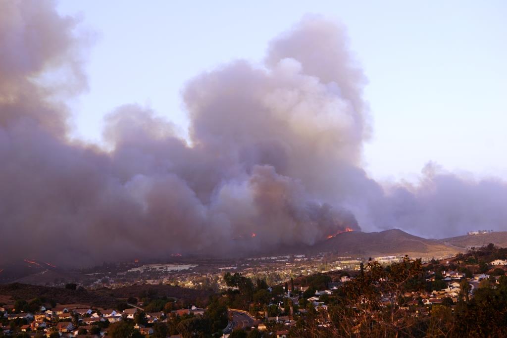
I was in Newbury Park on Halloween night when I looked up and saw orange flames in the distance. First I mentally freaked out because they looked pretty close by. But after checking out the Ventura County Fire Department (VCFD) “Pulsepoint” page (a web page that shows active and recent incidents in Ventura County), I learned this was most likely a fire on South Mountain, just south of Santa Paula.

Fires definitely can look closer than they actually are at night. Unfortunately, based on a number of recent experiences, I’m getting used to that.

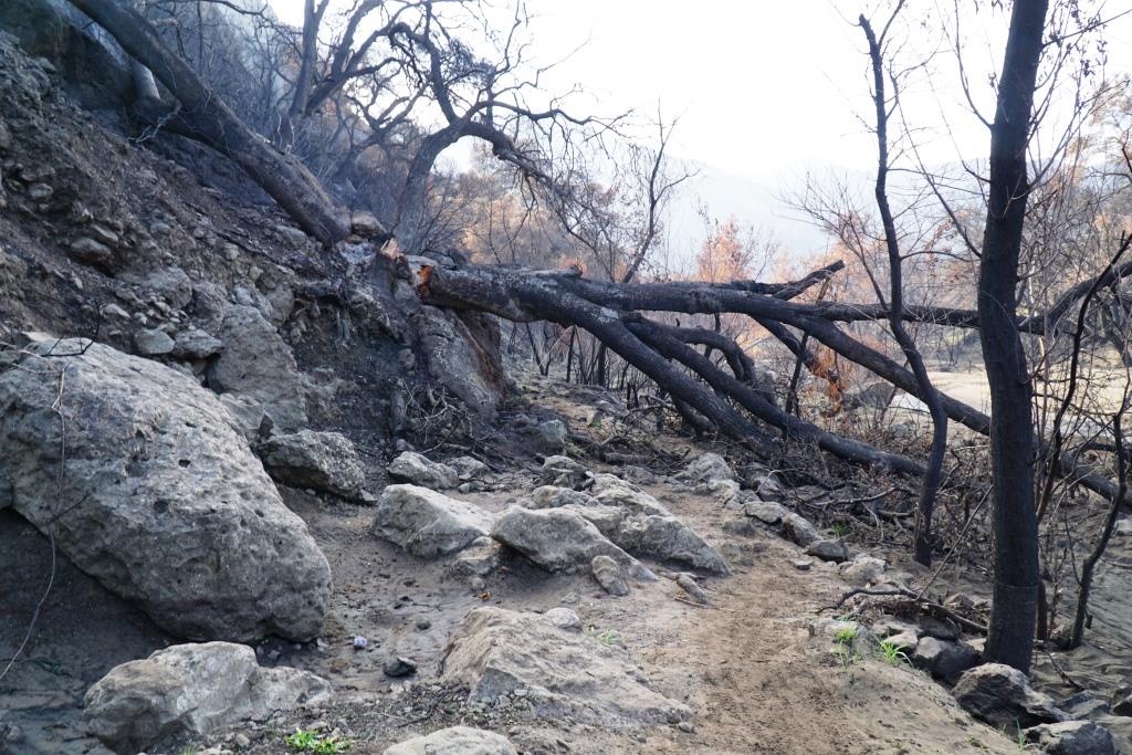
In this case, the fire on South Mountain was clearly seen from the Conejo Valley as the mountain is over 2,300 feet in elevation (which is about 500 feet shorter than Boney Peak here in the Santa Monica Mountains). Although unnerving to see, the flames were easily 10 to 12 miles away from the Conejo Valley, measured point to point.

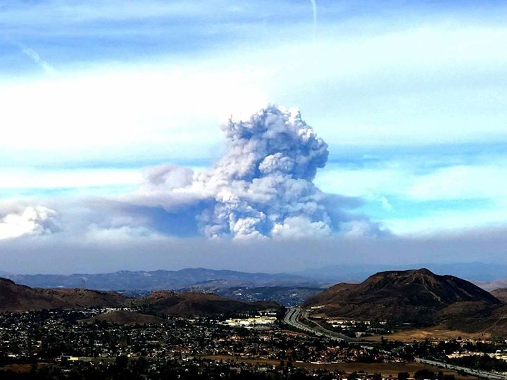
The fire was called the “Maria” Fire. I’m assuming it was named after something near the scene of the incident. There is a Santa Maria Street in Santa Paula that parallels the north side of South Mountain, so I’m going to assume that was what this wildfire was named after.

South Mountain overlooks the Santa Paula Airport and has the initials “SP” emblazoned on it. There are also oil fields clearly seen on the mountain as well as communications equipment at the top.

What a way to spend Halloween night. Within an hour of its identification, VCFD issued evacuation orders to homes in the perimeter south of the 126, north of Los Angeles Ave, east of Vineyard and west of Balcom Canyon Road.. About 1,800 homes were threatened as the fire crews strategically went into structure protection mode.

The wind driven fire was spreading quickly westbound, while moving slowly in the Santa Paula direction. Somis was also in the path of the fire.

One great thing about social media is that we have much more timely information about local disasters. The VCFD Public Information Officer Twitter account posts frequent updates, available to anyone via web browser at twitter.com/VCFD_PIO. (You don’t need to be a Twitter user to view the Tweets.) I’ve been impressed by the frequency and quality of communications from this VCFD account.

Of course, there are other sources for information, including the vcemergency.com website, which posts incident information, evacuations, emergency shelters and road closures.

As of Saturday, November 2nd at 7 p.m.., the Maria Fire stands at 9,412 acres and is 30% contained. Two structures were destroyed in the fire but at this time, no other structures are threatened. Evacuations orders were lifted at 2 p.m. today. A total of 1,579 total personnel are assigned to the fire, including 262 engines, 7 water tenders, 6 helicopters, 35 hand crews and 10 dozers.

Anticipated full containment is November 8th.

Wendy Fire in Newbury Park Burned 91 Acres in Rancho Sierra Vista on October 10th

The “Wendy Fire” started at 7:11 p.m. on Thursday, October 10th in the Rancho Sierra Vista open space in Newbury Park, within the Santa Monica Mountains. The fire was seen quite clearly from Potrero Road, near the intersection of Wendy Drive.

It was a nerve wracking moment for local residents, as the flames were clearly visible and the Santa Ana winds were unpredictable. It was just six years ago that the Springs Fire burned near this area, down to PCH, and then back up towards the Conejo Valley when the winds shifted.

But our local fire responders, armed with a helicopter doing constant water drops and a bulldozer going up to and nearly into the flames to create a fireline, along with winds that were pushing towards the ocean, we managed to survive unscathed.

Thankfully, no structures were lost. We were quite concerned that the flames might impact the Satwiwa Native American Culture Center. The National Park Service announced on Friday that it was not impacted.

The cause of the fire is currently unknown.

It was last reported that the blaze was 91 acres.

The park and surrounding trails are expected to reopen on Sunday, October 13 at 6 a.m. Saturday events at this site have been cancelled.

The site will remain closed through Saturday, October 12th. The park and surrounding trails will reopen at 6am on Sunday, Odtober 13th.

Firefighter engines and personnel from Santa Monica Mountains National Recreation Area, Yosemite National Park, Redwood National Park, California State Parks, Ventura County Fire, Los Angeles County Fire, Los Angeles City Fire, Ventura City and Oxnard City and Ventura County Sheriffs (Thousand Oaks) assisted in fighting the fire.

MASH Set at Malibu Creek State Park Survives the Woolsey Fire

We know the Woolsey Fire tore through Malibu Creek State Park last month and we also read news reports that the MASH set was “destroyed” by the fire.

NOT SO!

The park reopened to the public on December 18th and today, December 22nd, I was able to make my way down Crags Road from the MCSP parking lot to check things out.

Greening up nicely in Malibu Creek State Park after some recent rains, roughly six weeks after the Woolsey Fire devastated the area on is way to Malibu.

Greening up nicely in Malibu Creek State Park after some recent rains, roughly six weeks after the Woolsey Fire devastated the area on is way to Malibu.

There were hundreds of charred trees on the way to the MASH site, along with plenty of downed trees and rocks on the path. The hike is not for everyone, especially at this early stage. And there are few points where the path is not particularly clear - unless you already know the way there from prior visits.

But when I got there, to my pleasant surprise, pretty much all of the MASH set items that were previously there were still there, looking pretty much the same. The exception to that is that the iconic M*A*S*H signpost was a bit hard to read. The sign was still there though, apparently unharmed. It may be in need of some refurbishment, however.

As you can see, getting to the MASH site has some challenges resulting from the Woolsey Fire and subsequent rainstorms. Best to wear very solid hiking shoes and stay on the path as best you can.

As you can see, getting to the MASH site has some challenges resulting from the Woolsey Fire and subsequent rainstorms. Best to wear very solid hiking shoes and stay on the path as best you can.

Alan Alda discusses the final episode of MASH and talks about the fire that raged through Malibu Creek State Park at the time. The final episode was actually filmed before the fire came through.

Historic Structures Destroyed and Other Areas Burned by the Woolsey and Hill Wildfires in the Santa Monica Mountains

The Woolsey Fire of November 2018 has burned nearly 100,000 acres of land, including 20,839 of the 23,621 National Park Service (NPS) owned acreage within the boundary of the Santa Monica Mountains National Recreation Area (SMMNRA).

Other partners in management of the SMMNRA include California State Parks, the Mountains Recreation and Conservation Authority and the Santa Monica Mountains Conservancy.

The Western Town at Paramount Ranch was destroyed. The only buildings left intact are the church building and train station. The NPS has announced “The Paramount Project” campaign to raise fund and rebuild Western Town in 24 months. Also destroyed was the residence of a park ranger. NOTE: PARAMOUNT RANCH WAS RE-OPENED TO THE PUBLIC ON 12/3/18.

Farmer’s Exchange structure in the Western Town at Paramount Ranch

Farmer’s Exchange structure in the Western Town at Paramount Ranch

The aftermath at Paramount Ranch’s Western Town.

The aftermath at Paramount Ranch’s Western Town.

The Morrison Ranch House in the Cheeseboro Canyon area of Agoura Hills, was destroyed. Rancher John Morrison and his family occupied this house in 1904 and lived and worked in the home for nearly 60 years. The original ranch house, modified over the years, dates back to the late 1800s. It is now gone.

Morrison Ranch House one year ago - November 2017.

Morrison Ranch House one year ago - November 2017.

Morrison Ranch House after the Woolsey Fire (Photo courtesy of Friends of Morrison Ranch House at twitter.com/SantaMonicaMtns/status/1062025537927827456)

Morrison Ranch House after the Woolsey Fire (Photo courtesy of Friends of Morrison Ranch House at twitter.com/SantaMonicaMtns/status/1062025537927827456)

Peter Strauss Ranch was decimated by the Woolsey Fire. The Rocky Oaks ranger residence and archives building were destroyed and Rocky Oaks park was just devastated; you can barely recognize it. The Arroyo Sequit ranger residence was destroyed.

The National Park Service’s Santa Monica Mountains National Recreation Area website at www.nps.gov/samo/index.htm will post updates.

Strauss Ranch Bench.JPG

Other structures destroyed in the Santa Monica Mountains falling into lands maintained by other organizations include the historic Sepulveda Adobe, Red House, White Oak Barn and Reagan Ranch. Malibu Creek State Park updates at www.parks.ca.gov/?page_id=614.

KTLA reported on November 11th that the Woolsey Fire also destroyed the MASH set. After the park reopened on December 18th, I checked it out and found that nearly the entire set is still there.. The iconic sign is still in place, though it is barely readable and needs some work.

Iconic sign post Woolsey Fire. Faded but still standing!

Iconic sign post Woolsey Fire. Faded but still standing!

Iconic MASH sign last March.

Iconic MASH sign last March.

NOTE: THE TAPIA DAY-USE AREA WITHIN MALIBU CREEK STATE PARK WAS RE-OPENED ON 12/3/18.

MALIBU CREEK STATE PARK DAY-USE AND BACKCOUNTRY TRAILS REOPENED 12/18/18. CAMPGROUND REMAINS CLOSED UNTIL FURTHER NOTICE.

Other California State Park properties impacted by the Woolsey and Hill Fires, include Leo Carrillo State Park (fire burned through the campground, the visitor center, sector office, employee residences, three lifeguard towers, Leo Shop structures, the Junior Lifeguard Complex and several restrooms) and El Matador Beach. www.parks.ca.gov/NewsRelease/852 REOPENED 11/27/18

Also temporarily closed, but not on fire, include Point Mugu State Park, Malibu Lagoon State Beach, Point Dume State Beach, La Piedra and El Pescador Beaches and Topanga State Park. THESE WERE REOPENED 11/27/18.

The Mountains Recreation and Conservation Authority announced a number of parks it manages are closed as a result of the Woolsey Fire, including Escondido Canyon Park, Las Virgenes View Trail, Triunfo Creek Park, Upper Las Virgenes Canyon Open Space Preserve, Charmlee Wilderness Park, Zev Yaroslavsky Las Virgenes Highlands Park and others. (Updates at mrca.ca.gov/press/mountains-recreation-and-conservation-authority-issues-list-of-park-closures.) Amazingly, while much of Charmlee was burned, the structures survived. UPDATE 1/11/19: MRCA ANNOUNCED ALL OF THE ABOVE TRAILS, WITH THE EXCEPTION OF ESCONDIDO AND CHARMLEE, HAVE REOPENED.

On to Camarillo…Camarillo Grove Park sustained fire damage from the Hill Fire and is closed until further notice. Updates at www.pvrpd.org/parks/dog/grove.asp or 805.482.1996.

MASH set at Malibu Creek Park in pre-Woolsey Fire days.

MASH set at Malibu Creek Park in pre-Woolsey Fire days.

Reagan Ranch house in pre-Woolsey Fire days.

Reagan Ranch house in pre-Woolsey Fire days.

Charmlee Wilderness Park entrance post-Woolsey Fire (Photo Credit: MRCA)

Charmlee Wilderness Park entrance post-Woolsey Fire (Photo Credit: MRCA)

Charmlee entrance is greener, yet still dry, times.

Charmlee entrance is greener, yet still dry, times.

The replica Chumash Village at the Chumash Indian Museum / Oakbrook Regional Park was destroyed by the Woolsey Fire, which is so unfortunately as the place was just magical. However, most of the beautiful oak trees canopying the grounds were saves.

Kristy’s Roadhouse Malibu and SIP Malibu at the corner of Kanan and Sierra Creek Road were destroyed by the Woolsey Fire.

Kristy’s Roadhouse Malibu and SIP Malibu at the corner of Kanan and Sierra Creek Road were destroyed by the Woolsey Fire.

Simi Valley and Oak Park: Update 12/7/18 - RSRPD indicates Challenger Park in Simi Valley and Eagle View Park in Oak Park remain closed. The public is asked to stay out of Corriganville Park, the Wood Ranch Trailhead open space and trails west of the Long Canyon Trail. Oak Canyon Community Park, including the dog park, are closed until further notice. Updates at rsrpd.org.

Calabasas: The Calabasas Bark Park at 4232 Las Virgenes Road is currently closed as a result of the Woolsey Fire.

Brush Fire Information and Links for Hill Fire and Woolsey Fire November 8, 2018

Hill Fire around 3:15pm on Thursday, Nov 8th, seen from west Los Robles Trail in Newbury Park.

Hill Fire around 3:15pm on Thursday, Nov 8th, seen from west Los Robles Trail in Newbury Park.

The Conejo Valley and nearby areas have been inundated by emergencies, including the Borderline Bar & Grill shooting and the fires - Hill Fire (originated 2:03 pm in the Hill Canyon area of Thousand Oaks/Newbury Park) and the Woolsey Fire (originated 2:25 pm in the Simi Hills near the old Rocketdyne facility, 25000 Woolsey Canyon Road - bordering Canoga Park in Los Angeles County).

While CVG is not a news site and we cannot provide up to the minute updates, we do want to provide information and links to help local resident stay closely dialed in.

For updates including evacuations, shelters, etc., visit www.vcemergency.com. Or call (805) 465-6650.

For evacuation notifications, sign up by texting VCAlert to 313131 or visit www.vcalert.org.

If you are a Twitter user, the Ventura County Fire Department Public Information Officer provides periodic updates via Tweets at twitter.com/VCFD_PIO. The VCFD Twitter page also provides updates and some useful "Retweets" from other sources at twitter.com/VCFD.

Ventura County emergency alert radio stations: KVTA 1590 AMKHAY 100.7 FM, KMLA 103.7 FM (SPANISH)

VISIT VCEmergency.com FOR THE LATEST UPDATES ON MANDATORY AND VOLUNTARY EVACUATIONS, ROAD CLOSURES AND EVACUATION CENTERS.

City of Westlake Village emergency updates: (Woolsey Fire): www.wlv.org/AlertCenter.aspx

Donations:

  • Ventura County Community Foundation has established a Hill Fire/Woolsey Fire Sudden and Urgent Needs Effort Fund

  • Founded in response to the destruction of the Woolsey Fire, LV Fire Relief raises money and collects goods for families who lost their homes or have been displaced long-term by severe damage to their homes. LV Fire Relief is a community effort by local parents, staff, students, and business owners. Donations are processed with support of the Southeast Ventura YMCA and are tax-deductible. For more information, visit lvfirerelief.org.

HillFire315 2.JPG

Other Updates:

  • National Park Service announced the Western Town at Paramount Ranch has been destroyed by the Woolsey Fire.

  • Peter Strauss Ranch was largely destroyed by the Woolsey Fire.

  • The Mountains Recreation and Conservation Authority announced a number of parks it manages are closed as a result of the Woolsey Fire, including Escondido Canyon Park, Las Virgenes View Trail, Triunfo Creek Park, Upper Las Virgenes Canyon Open Space Preserve, Charmlee Wilderness Park, Zev Yaroslavsky Las Virgenes Highlands Park and others. (Updates at mrca.ca.gov/press/mountains-recreation-and-conservation-authority-issues-list-of-park-closures.)

  • The MASH set and Reagan Ranch at Malibu Creek State Park were destroyed by the Woolsey Fire, according to the L.A. Times.

  • Malibu Creek State Park was closed until 12/18/18 due to the Woolsey Fire. State Parks lost some structures, such as employee residences, the historic Sepulveda Adobe, Red House, White Oak Barn and Reagan Ranch. For the latest information on how the wildfires have impacted state parks, visit www.parks.ca.gov/newsroom

  • Other California State Park properties impacted by the Woolsey and Hill Fires, include Leo Carrillo State Park (fire burned through the campground, the visitor center, sector office, employee residences, three lifeguard towers, Leo Shop structures, the Junior Lifeguard Complex and several restrooms) and El Matador Beach. www.parks.ca.gov/NewsRelease/852

    • Also temporarily closed, but now re-opened, were Point Mugu State Park, Malibu Lagoon State Beach, Point Dume State Beach, La Piedra and El Pescador Beaches and Topanga State Park.

  • The Morrison Ranch House in Cheeseboro Canyon in Agoura Hills was destroyed by the fire.

  • The Hill Canyon Bridge in Thousand Oaks was torched and we be closed for at least several weeks until repaired.

  • The replica Chumash Village at Oakbrook Regional Park in Thousand Oaks was destroyed by the Woolsey Fire.

  • Conejo Open Space closed until further notice. Follow the COSCA Facebook Page for updates.

    • Opening 11/16: Los Robles, Rancho Potrero, Dos Vientos, Tarantula Hill

    • Opening 11/17: Wildwood

    • Closed until further notice: Hill Canyon, Western Plateau, Conejo Canyons, Lang Ranch, Woodridge, Oakbrook, Hillcrest and North Ranch open space areas.

    • As of mid-January 2019: All open except Hill Canyon Bridget and Oakbrook open space.

  • Rancho Simi Rec & Park District parks/trails closed (as of 11/19/18):

    • Corriganville, Coyote Hills and Challenger parks in Simi Valley and Eagle View Park in Oak Park.

    • Wood Ranch Trailhead open space area and Long Canyon Trail

    • Oak Canyon Community Park

    • Update at rsrpd.org

  • ABC News list of homes burned by Woolsey Fire.

  • Woolsey Fire

    • 83,250 acres as of 7pm 11/10. 5% containment. Full containment expected by 11/15. 177 structures destroyed; 2 damaged.

    • 83,275 acres as of 7am 11/11. 10% containment. Full containment expected 11/17. 177 structures, destroyed, 2 damaged.

    • 85,500 acres as of 7pm 11/11. 15% containment. Full containment 11/17. 2 civilian casualties. 3 firefighter injuries.

    • 11/12 7pm: 93,662 acres, 30% containment. Full containment now 11/15. Preliminary estimate 435 structures destroyed;.

    • 11/13 7am: 96,314 acres, 435+ structures destroyed; 24 damaged. 35% containment. Full containment pushed back to 11/18.

    • 11/13 7pm: 97,114 acres, 40% containment; full containment still 11/18.

    • 11/15 7am: 98,362 acres, 57% containment. 504 structures destroyed (483 prelim; assessment ongoing - 370 confirmed destroyed and 96 confirmed damaged). Full containment expected by 11/19.

    • 11/15 7pm: 98,362 acres, 62% contained, 548 structures destroyed, 157 damaged. 3 civilian casualties, 3 firefighter injuries. Full containment by 11/19.

    • 11/16 7am: 98,362 acres, 69% contained. 616 structures destroyed; 183 damaged. Full containment by 11/19.

    • 11/16 7pm: 98,362 acres, 69% contained. 713 structures destroyed; 201 damaged. Full containment 11/19.

    • 11/17 7pm: 98,362 acres, 84% contained. 1,008 structures destroyed; 271 damaged. Full containment 11/22.

    • 11/18 7pm 96,949 acres (must have done a reassessment), 91% contained. 1,452 structures destroyed, 337 damaged.

    • 11/19 7am 96,949 acres, 94% contained. 1,500 structures destroyed, 341 damaged. Full containment 11/22.

    • 11/19 7pm No change other than 96% contained.

    • 11/20 6:30pm: 96,949 acres, 98% contained; full containment expected tomorrow. 1,643 structures destroyed; 364 damaged.

    • 11/21 6:30pm: 96,949 acres, 100% contained!

  • Hill Fire

    • 4,531 acres as of 7pm 11/10. 65% containment; full containment expected by 11/15. 2 structures destroyed; 2 damaged.

    • 7am 11/11 - No change other than 70% containment.

    • 7pm 11/11 - No change other than 75% containment.

    • 7pm 11/12 - 4,531 acres; 80% containment.

    • 7am 11/13 - same acreage, 90% containment

    • 7pm 11/13 - same acreage; 92% containment

    • 7am 11/15 - same acreage; 97% containment. Full containment anticipated tomorrow.

    • 7pm 11/15 - same acreage; 99% containment; full containment 11/16.

    • 11/16: Fully contained! Cal Fire seeks the public’s help determining what appears to be human cause to the fire. Possible $10K reward.

  • Pepperdine University has announced that classes will be cancelled until after Thanksgiving as a result of the Woolsey Fire.

  • CSUCI has announced it has suspended classes through Thanksgiving, though the campus itself will be open November 15-21.

  • Schools in the Conejo Valley, Oak Park and Las Virgenes Unified School District have closed through the Thanksgiving holiday.

Thomas Fire Grows to 2nd Largest Fire in California History and is 55% Contained

UPDATE: Since this post, the fire grew to burn a total of 281,893 acres (440 square miles), making it the largest wildfire in modern California history (which was subsequently surpassed by the Mendocino Complex Fire of 2018, which burned a total of 459,123 acres).

The Thomas Fire has now burned 272,000 acres, making it the 2nd largest wildfire in California since accurate records of fires were maintained in 1932. Only the 2003 Cedar Fire in San Diego County was larger, at least as of tonight, at 273,246 acres. 

Cal Fire anticipates the Thomas Fire to continue burning until full containment is achieved by January 7th. That would mean the fire is expected to burn continuously for 34 days. As of tonight the Thomas Fire was 55% contained.

Areas of particular focus by firefighters are Montecito, Rose Valley and Fillmore. The area between Fillmore and Ventura along Highway 126 will remain in patrol status.

The Thomas Fire originated in Santa Paula the night of December 4th near county-managed Steckel Park, the Ventura Ranch KOA and Thomas Aquinas College (which the fire was named after).

The main store and cabins at the KOA were destroyed but much of the campgrounds is intact. Management indicates they will be rebuilding, with a goal of re-opening in the Spring.

The college did not sustain serious damage thanks to the efforts of firefighters, though there will still be extensive recovery costs. President McLean provides more information in the video below. Donations to help the school in its recovery efforts are accepted at thomasaquinas.edu/news/help-us-recover.

Thomas Fire Leapfrogs Matilija Fire of 1932 to Become Largest Fire in Ventura County History

UPDATE: The Thomas Fire was fully contained on January 12, 2018, having burned 281,893 acres (roughly 440 square miles). The fire destroyed 1,063 structures and damaged 280 others.

In August 2018, the Thomas Fire was surpassed by the Ranch Fire - part of the Mendocino Complex Fire - the combination of the River Fire and Ranch Fire - that burned in Mendocino, Lake, Colusa and Glenn counties. The Ranch Fire alone burned 410,203 acres. The combined fire burned 459,123 acres.

View of the smoke plume coming from the Thomas Fire, as seen from the hills of the Conejo Valley today, Sunday, December 10th (Photo Credit: L. David Irete).

View of the smoke plume coming from the Thomas Fire, as seen from the hills of the Conejo Valley today, Sunday, December 10th (Photo Credit: L. David Irete).

Authorities reported tonight that the Thomas Fire has now grown to over 230,000 acres burned, making it the largest ever recorded wildfire in Ventura County history and the 5th largest ever in California. It would appear that within the next day or two, the Thomas Fire will surpass the 2007 Zaca Fire in Santa Barbara County and Rim Fire in Tuolumne County to became the 3rd largest fire in California history.

The fire, which was first reported in Santa Paula last Monday, December 4th, at 6:36PM, actually dropped from 15% to 10% containment today, as it rages into Santa Barbara County.

The fire has destroyed 790 structures and damaged an additional 191 to date. As of Sunday night, December 10th, 18,000 structures are threatened.

For Ventura County Thomas Fire updates, visit readyventuracounty.org. Mandatory evacuation orders have been lifted in a number of areas, but continue in specific locations in Ventura, the entire community of Casitas Springs, Ojai and other areas. The Ready Ventura County site also has information about where to obtain N95 masks in Santa Paula, Ventura, Ojai and Oxnard. What does N95 mean? The respirator will block at least 95% of small particles.

NEW: The Ventura County Recovers website has been established at venturacountyrecovers.org as a resource for those impacted by the fire.

Santa Barbara County is now under greater risk from the fire and mandatory evacuations orders have been issued in areas stretching from the Ventura/Santa Barbara County line to Goleta. Visit www.countyofsb.org/thomasfire.sbc for details.