Satellite Tracking Station at Laguna Peak for the Naval Satellite Operations Center Point Mugu (Now 10th Space Operations Squadron)

UPDATE: On June 6, 2022, the Naval Satellite Operations Center that previously was responsible for the Laguna Peak station was transferred from the Navy to the Space Force, specifically, the 10th Space Operations Squadron (10 SOPS). The mission of 10 SOPS, which is headquarted at Naval Base Ventura County, is to operate, manage, and maintain assigned satellites and ground systems, providing continuous and reliable satellite communications in direct support of Fleet, Joint, and Interagency operations. Learn more at THIS LINK and about 10 SOPS at www.petersonschriever.spaceforce.mil/About-Us/Fact-Sheets/Display/Article/3146952/10th-space-operations-squadron.

(Military photo of Laguna Peak.)

(Military photo of Laguna Peak.)

If you’re in the vicinity of Thornhill Broome State Beach and Sycamore Cove Beach in Point Mugu or hiking up the Chumash Trail to the La Jolla Valley in Point Mugu State Park, you’ve probably noticed some futuristic looking equipment up on a hill to the west.

That hilltop is the 1,421 foot Laguna Peak in the westernmost tip of the Santa Monica Mountains, home to the Naval Base Ventura County’s Satellite Tracking Station.

The tracking station monitors rocket launches from Vandenberg Air Force Base and other sites and is a part of a network of satellite control facilities that includes stations in Prospect Harbor, Maine, Rosemount, Minnesota and the Lincoln Laboratory in Massachusetts.

laguna peak from PCH.JPG

Northbound PCH Just South of Mugu Rock: 1950 and 2019

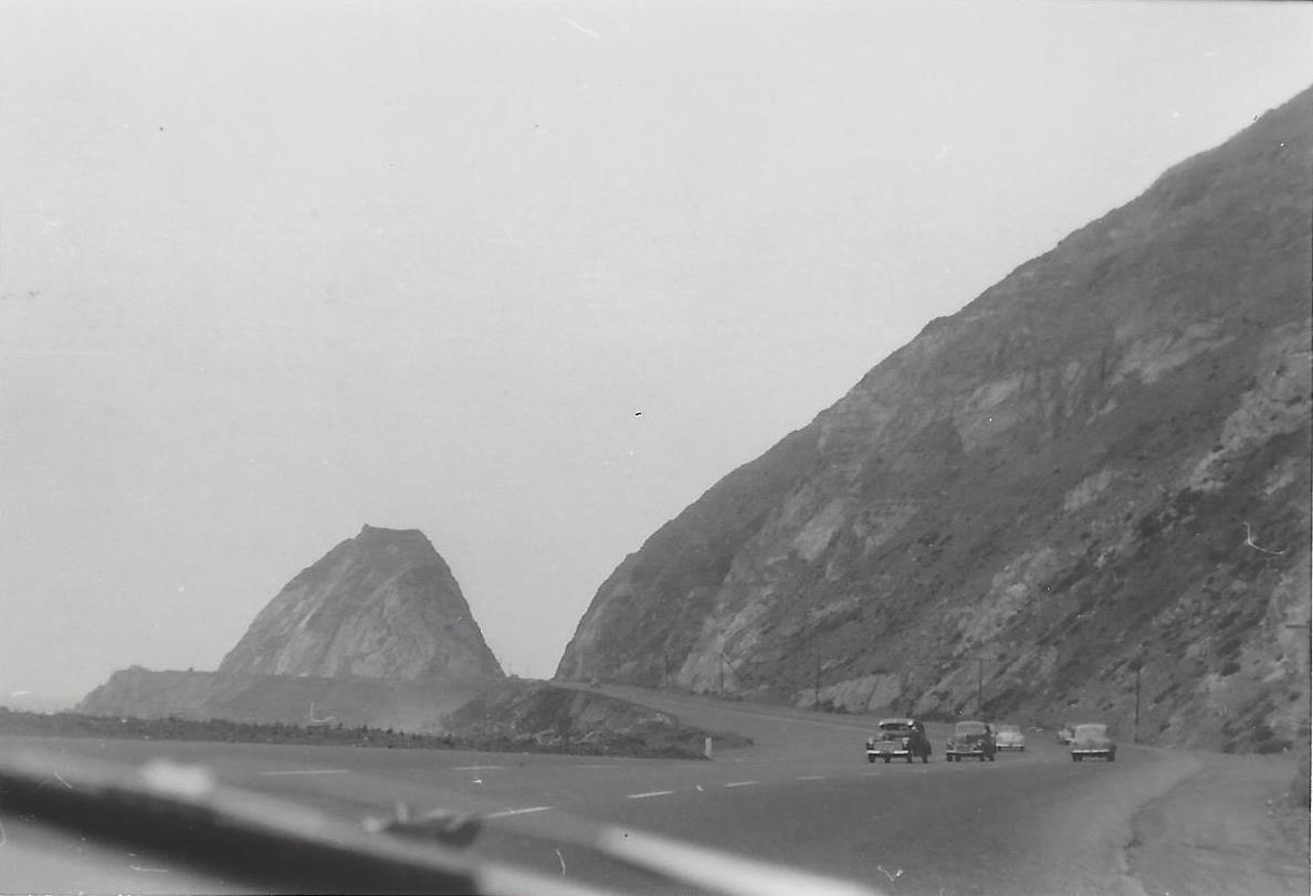
Mugu Rock came into existence in 1940 when a 200 foot cut was made into the mountain. Today it is an iconic scene that is often seen in auto commercials.

Taken on July 2, 1950, this is a view of Mugu Rock from the shoulder of northbound Pacific Coast Highway (SR 1). From a private collection. And below it is the same view, remarkably similar, 69 years later, on April 20, 2019. Thankfully, some things never change.

Mugu Rock 7.2.50.jpg
Mugu Rock 4.20.19.JPG

Building Pacific Coast Highway Around Point Mugu in 1923-1924

Point Mugu before and after creation of a narrow road around it in 1924.

Point Mugu before and after creation of a narrow road around it in 1924.

According to the California Highway Commission in the October 1924 issue of “California Highways,” perhaps the most dangerous and difficult piece of construction work on the California state highway system at that time was the 3800 feet of grading AROUND Point Mugu.

For those driving Pacific Coast Highway in Ventura County past Mugu Rock, there are clear signs of this old route that took automobiles on a precarious route around Point Mugu.

Peaking through the fence towards the old road around Mugu Rock.

Peaking through the fence towards the old road around Mugu Rock.

The new and still existing route was created by blasting a massive hole through Point Mugu to create Mugu Rock in 1937 to 1940.

The work to complete this section of the Oxnard to San Juan Capistrano PCH route was authorized by a bond issue in 1919.

The project averaged 60 workers who moved 108,000 cubic yards or rock at a total cost of $108,500 (heck, that would be the cost of a pool addition and new kitchen remodel today). The cut around Point Mugu ranged from 40 feet on the ocean side to 115 feet on the high side in creating the narrow, short-lived roadway.

The California Highway Commission ended its article by stating “…along this piece of rugged coast line the Old Pacific is recognized as an arch enemy to whom we must trust as little as possible of our costly highway.”

Mugu Rock at Point Mugu

Point Mugu is an unincorporated part of Ventura County that is derived from the Chumash word Muwu, or beach. Other than the Naval Base, probably the most well known fixture in Point Mugu is the Mugu Rock. Mugu Rock is a large rock formation that was formed when Pacific Coast Highway was built and cut through the mountain that now resides on the other side of PCH. Before PCH was built, a road went around the rock, where a chain link fence has been placed to keep people away from this hazardous area adjacent to the Pacific Ocean.  PCH was cut through Point Mugu from October 1937 to February 1940, according to this interesting KCET article.

MuguRock_pch.JPG

Mugu Rock is located just a few miles near the northwest tip of PCH before it veers north towards Oxnard. It is about a 10 mile drive from the Camarillo Premium Outlets and about 20 miles from the heart of Thousand Oaks taking either the 101/Lewis Road route or the slightly slower, curvy and interesting Potrero Road route.

Professional landscape and wildlife photographer Greg Clure of Newbury Park has shared a couple neat images facing Mugu Rock from the south. Visit Greg's website at www.gregclurephotography.com for more of his outstanding work.

ClureMuguRock2.jpg
ClureMuguRock1.jpg

And here is some not so professional video footage of Mugu Rock from the north.

Mugu Rock Then and Now

Mugu Rock is a large rock formation formed when a 200 foot deep cut was made into the rocky ridge from October 1937 to February 1940. Prior to the modern day PCH at Mugu Rock (at the time called U.S. 101 Alternate (State Route 60), drivers went around a 275 foot radius curve that is now fenced off.

The photos in the video above from the October 1940 edition of California Highways and Public Works show what it looked like before, during and after the cut was made, compared to what it looks like today.

Ride to the Flags 2022 9/11 Tribute Filmed at Mugu Rock in Point Mugu

Ride to the Flags began in 2008, accompanying the Wave of Flags 9/11 Memorial at Pepperdine University. Although not officially associated with the memorial - the ride does end at the memorial for a short service. Ride to the Flags is an all volunteer, charity ride with 100% of the riders' donations going to an injured warrior. The ride has raised hundreds of thousands of dollars for select warriors in need of rehab equipment and life-enhancing services. Learn more at www.whiteheart.org/ridetotheflags.

This year's event raised funds for Navy EOD (Explosive Ordnance Disposal) tech Jordan Stevenson, who sustained sever injuries on his first deployment to Afghanistan with the 3rd/75th rangers. Learn more about Jordan's story at youtu.be/T7DWSo3_1Es

This footage was taken from just southeast of Mugu Rock in Point Mugu State Park, just a couple miles away from the start of the event at Naval Base Ventura County.

Mugu Canyon Rest Area in Oxnard

Mugu Canyon 1.jpg

The Mugu Canyon Rest Area is located at 5735 Pacific Coast Highway in Oxnard, at the corner where PCH veers due north near Naval Base Ventura County.

“Rest Stop for Weary Travelers”

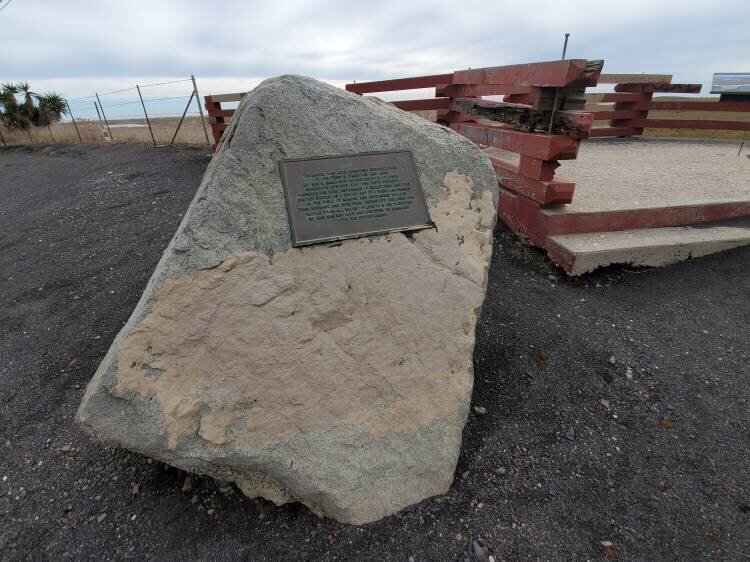
There is a viewing platform at the rest area with a bronze dedication tablet affixed to a rock, as well as two interpretive panels.

The tablet reads “Dedicated One July, Nineteen 1975 to Professor Emeritus and Mrs. George E. MacGinity in recognition of their scientific efforts for over fifty years to preserve the vital estuaries of California and the United States as a whole, and for their leadership in the field of marine and estuarine biology. This husband and wife team exemplify the need for people from all walks of life to work together so that man may live and prosper in harmony with his environment.”

The first interpretative panel points out that the Mugu Lagoon is the largest remaining coastal wetland in Southern California, providing much-needed food, shelter and breeding habitat. Naval Base Ventura County preserves and protects this area for wildlife and bird lovers.

The second panel describes the Chumash “House of the Sea,” a tomol, or plank canoe. Chumash mariners would paddle on a tomol, built by splitting driftwood, sewing planks with cordage and caulking with tar, as far as the Channel Islands. They would fish the open waters, return to this lagoon and the nearby Chumash village of Muwu.

Mugu Canyon 2.jpg
Mugu Canyon 3.jpg