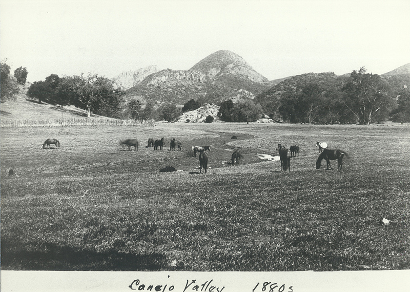
The Hunt Olive Tree in Thousand Oaks is a Living Link to Conejo Valley History

Richard Orville Hunt and his wife Mary Jane purchased a large parcel of land in the Conejo Valley in 1876 in what is now Lynn Ranch. He called it Salto Ranch. Hunt also served as postmaster of the Newbury Park Post Office for 18 years and was well known in the local community. While his former land now is populated with family homes, one part of Hunt's ranch lives on.

HuntOliveTreeSprouts2013_2.JPG

For those of you who drive past the Sprouts Market at 600 West Hillcrest, perhaps you have noticed the historic landmark marker situated in front of the last remaining olive tree from Hunt's orchard. The Hunt Olive Tree was designated a Ventura County Historic Landmark in 1981, when the tree was over 100 years old. That would make this olive tree over 130 years old today.

HuntOliveTreeSprouts2013.JPG
HuntOliveTreeCCSign.jpg

For nostalgia buffs, to the right is a view of the Hunt Olive Tree marker back in the day that Circuit City was located here. It closed in late 2008. This tree was moved to its current home in 1993. I'm not sure why...perhaps to say hello to the thousands of residents who pass by each day. What a fine specimen this link to the past is. The Hunt Olive Tree is also Historical Landmark #4 in the City of Thousand Oaks.

So be sure to say hello to this tree that sits next to the Sprouts Farmers Market sign at Hillcrest and Lynn and do be nice to him (or her). She's older and wiser than all of us combined, having seen and lived through the growth of our local community.

Aviation Museum of Santa Paula is Open to the Public the First Sunday of Each Month

The Santa Paula Airport was dedicated in August 1930. Today it is a non-towered facility with nearly 300 aircraft, handling approximately 97,000 arrivals/departures a year. Much of the original 1930’s-era facilities still exist and are used today, giving the airport a very authentic representation of the Golden Age of Aviation.

Located at the Santa Paula Airport, the Aviation Museum of Santa Paula is open the first Sunday of each month, with an array of hangars open to the public from 10 a.m. to 2 p.m.

Upcoming 2026 dates: Feb 1, Mar 1, Apr 5, May 3, June 7, July 5, Aug 2, Sep 6, Oct 4, Nov 1, Dec 6

SPAirport_Dedication.JPG

Each of the privately owned hangars houses a variety of vintage aircraft and collections of various types, as well as other memorabilia, such as antique radios, model aircraft and race cars. Some hangars celebrate highlights of fascinating aviation careers, while others contain antique aircraft undergoing the process of restoration. Hangar owners or docents are available to answer questions. 

SPAviationMuseum.JPG

You've got to take the time to stop by. It is fun, low key and quite interesting. The hangars are directly adjacent to the airfield, so you are guaranteed to see aircraft taking off and landing up close.

Obviously an aviation aficionado in this hangar!

Obviously an aviation aficionado in this hangar!

The participating hangars are fairly well spread out at the 51 acre airport but if you're not up for walking, there's a complimentary tram that will take you around. These are some very nice people who have obvious passion for what they do and enjoy sharing it with the general public. I struck up conversations with several hangar owners and they were full of great stories and information.

AviationMuseumTram.JPG

There is no charge for visiting the Aviation Museum, though donations are welcomed. Visit www.aviationmuseumofsantapaula.org or call 805.525.1109 for more information.

The Museum is not open on rainy days.

Directions: Arriving by car from the east, exit the Santa Paula Freeway (SR 126) at 10th street, turn right off the ramp, and then a quick left onto Harvard Boulevard. Turn left at the next signal at Eighth Street, under the freeway, left onto Santa Maria Street and park in the lot. Arriving from the west, exit the freeway at Palm Avenue, turn right and then a quick left onto Santa Maria Street, about a half mile to the end at the parking lot.

Lots to see, both inside and outside of the hangars.

Lots to see, both inside and outside of the hangars.

The History of Lake Sherwood

Lake Sherwood as seen from the Sandstone Peak trail in the Santa Monica Mountains.

Lake Sherwood as seen from the Sandstone Peak trail in the Santa Monica Mountains.

Lake Sherwood is an unincorporated community of about 1,500 residents in Ventura County overlooking the Lake Sherwood reservoir. It is south of Thousand Oaks and west of Westlake Village, off of Potrero Road, accessible via Westlake Boulevard on the east and Wendy Drive and Reino Road in Newbury Park on the west.

For centuries, the Conejo Valley was inhabited by the Chumash. The Spanish came into the picture in the late 18th century and, when passing through what is now Hidden Valley, named the area the Potrero Valley.

The Potrero Valley was part of the original 48,761 acres constituting Rancho El Conejo. After California became the 31st state in 1850, a land commission was appointed to determine who owned land grants in the area.

Rancho El Conejo was sold in 1872 to John Edwards and Howard Mills. Mills received 22,240 acres that included the Potrero Valley in 1874. Mills sold the southeastern 8,476 acres to Joseph and Isabell McLaren Howard in 1875.

Photo of the Howard Ranch in the 1880s. The Howard residence was near where Triunfo Park is today in Westlake Village. (Courtesy of Conejo Through the Lens Collection; Thousand Oaks Library Special Collections.)

Photo of the Howard Ranch in the 1880s. The Howard residence was near where Triunfo Park is today in Westlake Village. (Courtesy of Conejo Through the Lens Collection; Thousand Oaks Library Special Collections.)

In 1888, the Howards sold the land to the Banning Company of Long Beach. In 1896, W. H. Matthiessen bought the Potrero Ranch from Banning. Then in 1904, Matthiessen built a 45 foot dam (originally called Alturas Dam) that created Potrero Lake (also referred to as Lake Matthiessen). Total capacity of the 156 acre lake, which today is called Lake Sherwood, is 877 million gallons of water.

In the early 1920s, the area around the lake was transformed into Sherwood Forest for the filming of Robin Hood, featuring Douglas Fairbanks. And of course that's where the name Lake Sherwood originated.

Meanwhile, W. H.'s son F. W. "Christy" Matthiessen married Elsie Mack in 1917. The couple made plans to develop the surrounding area as the Las Turas Lake Club in the 1920s. Except...they divorced in 1925, with Elsie receiving the portion of the ranch with the lake.

Elsie remarried. Her new husband's name was James Canterbury and briefly the lake became Lake Canterbury. After the stock market crash of 1929, the Canterburys sold the property to William Randolph Hearst. Hearst allowed the property to be used for filming of many films, including the 1938 The Adventures of Robin Hood.

In 1963, Dayton Realty purchased the lake and surrounding property. Dayton wanted to rezone the land to develop nearly 1,400 homes and commercial properties. This plan was fought off by local residents and rejected by the Ventura County Board of Supervisors.

From late 1983 to summer 1984, Dayton drained the lake, indicating that it needed to test the dam...which never happened...then never refilled the lake, leaving thousands of fish stranded and left to die in the mud. (Photo of draining of lake in January 1984)

Lake Sherwood was made available to the public after the depression of the 1930s until the lake was emptied in 1984.

A view of Lake Sherwood from the north off of Lake Sherwood Drive.

A view of Lake Sherwood from the north off of Lake Sherwood Drive.

In 1985, billionaire businessman David Murdock bought the dry Lake Sherwood lake bed and surrounding property.  His Ventura Farms and Lake Sherwood Ranch are located on the old F. W. Matthiessen property in Hidden Valley.

In 1986, heavy rains filled Lake Sherwood back up, though it would take many years for the lake to regain the wildlife it lost after it was emptied.

Murdock developed the community with over 650 homes in three gated neighborhoods along with the Sherwood Country Club and Sherwood Lake Club. The lake is now privately owned and is not open to the general public. Murdock passed away at the age of 102 on June 9, 2025.

Building of the Norwegian Grade from Conejo Valley to Camarillo 1909 to 1911

This historic photo and information was generously provided by Gerry Olsen, grandson of Nils Olsen, one of the original settlers in the Conejo Valley in the 1890s.

Back at the turn of the 20th century, farmers in the Conejo Valley grew dry crops like barley and wheat and had to take their harvest to Port Hueneme/Oxnard via horse-drawn wagons. Their only routes were the treacherous Potrero Road or down the unpaved Norwegian Grade to Santa Rosa Road.

So in 1909, with a $60 donation from the county to purchase dynamite, Norwegian families Olsen, Pedersen, other volunteers and paid helpers blasted into the hillside from Nils Olsen's property, 1 1/2 miles down to Santa Rosa Road.

It took two to three years to finish the project using the dynamite, manual labor and horse-drawn earth moving machines called Fresno Scrapers (named after a Scottish chap in 1883 who formed the Fresno Agricultural Works to manufacture it). 

Here is a historic photo of these early Conejo Valley roadbuilders.

I used to run up the grade from time to time and that was a pretty tight squeeze, with its steep descent and cactus on the side of the road. While most of us take the 23/101 freeways to get to/from Thousand Oaks/Moorpark/Camarillo these days, the Norwegian Grade provides an alternate 2-lane route with a direct linkage to the gritty Norwegian settlers who had the guts and determination to build it.

Purple Heart Trail Signs on U.S. Highway 101 in Ventura County Commemorate Veterans

Purple Heart Trail.JPG

In November 2014, Caltrans District 7 installed two signs designating a segment of U.S. Highway 101 as part of the National Purple Heart Trail — a system of signed highways, bridges and other monuments that honor soldiers who have received the Purple Heart medal.

One of these signs can be seen on the northbound 101 in Thousand Oaks, right before the Westlake Boulevard offramp. The other sign is near the Bates Road offramp off the southbound 101.

These two signs complete 240 continuous miles of Purple Heart trail in California, from Ventura County to Monterey.

Senate Concurrent Resolution No. 27 established specified portions of US Highway 101 in the counties of Santa Barbara and Ventura for inclusion in the National Purple Heart Trail.

The U.S. 101 in Ventura County is also dedicated to the U.S. Army's 101st Airborne Division as commemorated by "The Screaming Eagles Hwy - 101st Airborne Division" placed nearby.

Over 25 Things to Do in Agoura Hills

Agoura Hills Sign.JPG

The City of Agoura Hills incorporated in 1982 and is part of Los Angeles County. But we consider Agoura to be part of our family, consisting of Thousand Oaks, Newbury Park, Westlake Village, Oak Park and other communities that form the Conejo Valley.

Agoura Hills has an area of 7.86 square miles, with a population of approximately 20,000. It became the 83rd city in Los Angeles County when residents voted to incorporate, just one year after neighboring city Westlake Village incorporated.

Here is a compilation of things to do in the City of Agoura Hills.

Trails and Hiking

A "must do" in the Agoura Hills area is the hike to the old M*A*S*H TV series set in Malibu Creek State Park.

A "must do" in the Agoura Hills area is the hike to the old M*A*S*H TV series set in Malibu Creek State Park.

Kids

Fitness Related

Ah yes, comic relief courtesy of Caltrans signmakers in 2013 when a new Agoura Hills sign on the 101 was put up filled with typos. It was subsequently corrected.

Ah yes, comic relief courtesy of Caltrans signmakers in 2013 when a new Agoura Hills sign on the 101 was put up filled with typos. It was subsequently corrected.

Other Entertainment, Things to Do and Annual Events

  • The Canyon is the "go to" local club for a wide variety of great performers.

  • Whizin Market Square on Roadside Drive is a collection of eateries and unique stores.

  • The Reyes Adobe Historical Site in the heart of Agoura Hills is the first home built in the area, dating back to 1850. The City owns and maintains this adobe structure as a museum and cultural center, with an adjoining park.

  • The Annual Reyes Adobe Days Fall Festival takes place in October each year at the Reyes Adobe Historical Site and Park. Great family fun.

  • The Agoura Hills Recreation and Event Center hosts senior programs and teen programs "The Garage" and has a cool outdoor interpretive play area.

  • Water Wings Swim School is an indoor facility located in the Agoura Hills Town Center on Agoura Road.

  • The Agoura Hills Library is an 18,000 square foot facility near Agoura City Hall. It is part of the County of Los Angeles Public Library System.

  • The Great Race of Agoura Hills is the largest annual running/walking event in the Conejo Valley - an assortment of 7 races on roads and trails ranging from a family fun run to a 5K, 10K and two half marathons. Takes place in the March/April time frame.

  • For other events in Agoura Hills, visit THIS LINK.

The old Agoura sign on Agoura Road at Lewis Road.

The old Agoura sign on Agoura Road at Lewis Road.

Closed: Troutdale was a local fishing pond for those looking for the experience of fishing but without the hassle of driving far! Located just off of Kanan Road, near Triunfo Canyon. It appears to be closed as of summer 2018. Regency Agoura Hills 8 movie theater closed in February 2025.

E. P. Foster and Orpha Woods Foster Were Among the Early Settlers in the Conejo Valley

Eugene Preston and Orpha Woods Foster Family in 1890.

Eugene Preston and Orpha Woods Foster Family in 1890.

This is the Eugene Preston and Orpha Woods Foster family in 1890. This family has quite a history in Ventura County.

Eugene (E.P.) built a home in the Conejo Valley in 1874, where he operated a sheep business. Most of the 10,000 sheep perished in the terrible drought of 1876-1877. E.P. sold what remained of his business and moved to Ventura in 1877 (the same year that Egbert Starr Newbury and family moved back to the midwest...where Newbury passed away in 1880 at age 36).

Before the drought, in 1875, the Fosters became the parents of the first child of settlers born in the Conejo Valley. That daughter, the eldest of 10, only five - all daughters - of which survived childhood, was Orpha W. "Pearl" Foster. Pearl became president of Community Memorial Hospital in Ventura for over 25 years. She passed away at age 97 in 1973.

After his successes and struggles in the Conejo Valley, E.P. Foster became a highly successful entrepreneur and investor in Ventura, where he helped to establish the city's first electric light plant, developed natural gas wells and invested in the Bank of Ventura (now Bank of America) and the Union Oil Company. His philanthropic efforts led to the creation of Camp Comfort (the county's first park), Foster Park and the 91 acre Seaside Park, where the Ventura County Fair operates.

Additionally, the E.P. Foster Library on Main Street in Ventura is named after him; he and his wife donated funds for the original public library and city hall. The Fosters also donated funds and land to build what is now Community Memorial Hospital in Ventura.

The E.P. Foster Library is part of the Ventura County Library system The cities of Thousand Oaks, Simi Valley, Moorpark and Camarillo operate their own, independent library systems.