Learn About the Channel Islands at the Robert J. Lagomarsino Visitor Center in Ventura

For a fun, educational and local family field trip, visit the Robert J. Lagomarsino Visitor Center at Channel Islands National Park at the Ventura Harbor. This visitor center is free of charge and features a bookstore, marine aquatic life exhibits, a nicely done 25 minute movie, "A Treasure in the Sea" and friendly National Park Service staff to answer your questions.

CIVisitorCenter_1.JPG

Located at 1901 Spinnaker Drive, Ventura, the visitor cneter is open 8:30 am until 5 pm daily. On weekends and holidays (except Thanksgiving and Christmas Day) at 11 am and 3 pm, rangers offer a variety of free public programs covering the resources of the park. Click here for programs and events scheduled at the visitor center. Call 805.658.5730 for more information.

Nice scale model of the Channel Islands on display at the Visitor Center

Nice scale model of the Channel Islands on display at the Visitor Center

Indoor tidepool in the Visitor Center always grabs the kids' attention, along with other displays.

Indoor tidepool in the Visitor Center always grabs the kids' attention, along with other displays.

Deck on the 2nd floor of the Visitor Center has views towards Ventura Harbor and the ocean.

Deck on the 2nd floor of the Visitor Center has views towards Ventura Harbor and the ocean.

This placard on the second floor viewing deck of the visitor center reads as follows:

On a clear day you can see two of the five islands that compose the Channel Islands National Park - Anacapa and Santa Cruz. The park boundary also includes the waters one nautical mile out around the islands. The Channel Islands National Marine Sanctuary extends an additional five nautical miles out.

The Anacapas: When you look through the telescope (on the deck...or from other locations in Ventura County) you can see that Anacapa actually consists of three small islets. The Chumash Indians called Anacapa "Anyapa" meaning "ever-changing." It is an appropriate name as changing weather conditions modify the island's appearance. If you look at East Anacapa Island you may be able to see the lighthouse and the hole in the middle of arch rock.

Santa Cruz Island: Santa Cruz is the largest and topographically the most diverse of the Channel Islands. The highest point of Santa Cruz is Mount Diablo. It is nearly 2,400 feet high and is the highest mountain found on any of the Channel Islands.

Distance from Ventura (in miles): Anacapa (15), Santa Cruz (21), Santa Rosa (47), San Miguel (63) and Santa Barbara (52).

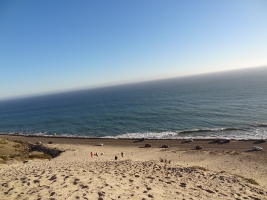
The Giant Sand Dune on PCH Across From Thornhill Broome Beach in Point Mugu

One of the many unique things to see in Ventura County is the gigantic sand dune located on the east end of Thornhill Broome Beach in Point Mugu.

ThornhillSandDune.JPG

Driving north up PCH, you'll see the sand dune on the east side after passing by Sycamore Canyon/Sycamore Cove Beach and before reaching the entrance to the Thornhill Broome Campground. 

ThornhillBroomeDune1.JPG

Park on the shoulder off of PCH. There's plenty of room, though you may be partially parked in the sand. You can also park on the beach side of PCH but rather than taking your life in your hands jaywalking across PCH, you're better off parking on the mountain side of the highway.

The mysteriously large sand dune is the result of "Aeolian transport," or the wind's movement of particles, in this case, sand. Quite steep this hill is, but your effort will be rewarded with some beautiful views of the Pacific Ocean. Plus, you get a nice bird's eye view of Mugu Rock.

ThornhillBroomeDune3.JPG

We noticed that the southern-most portion of the sand dune seems to have more large rocks in the sand from erosion of the mountains above. The northern hill, at least the several times we've now been there since originally posting this, has somewhat less rocks, leaving the sand smoother and more comfortable to walk on.

Going down the hill is certainly a lot easier than coming up!

Pick Your Own Produce at Underwood Family Farms in Moorpark

Underwood Sign.JPG

For a fun, inexpensive local family activity, stop by Underwood Family Farms in Moorpark for some "Pick Your Own" fun. Open most of the year, weather and farm conditions permitting. They've got everything from avocados, beans, beets, blackberries, broccoli, carrots, cauliflower, onions, cucumbers, on through spinach, squash and tomatoes, depending on time of year.

Underwood offers pull wagons, bags and containers for you to stash your haul. Then of course you pay for it. And if you can't find what you want in the fields, they may have it in their Farm Market.

  • Weekday Admission: $7 (as of June 2023)

  • Weekend and Holiday Admission: $10 (as of June 2023) (subject to change during spring, fall and Christmas festivals)

  • Children under 2 and parking free.

  • Wagon rides included with admission.

  • Seniors (65+), Military, Veterans and 1st Responders w/ID get $2 off.

Learn more at underwoodfamilyfarms.com/pick-your-own.

Hike to the Rock Pool at Malibu Creek State Park in Agoura Hills

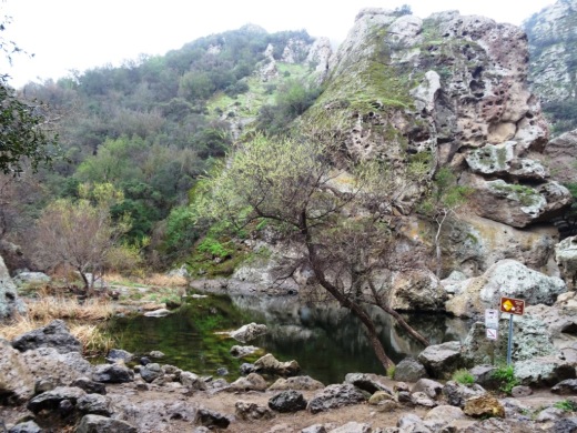
One of the most popular destinations in Malibu Creek State Park is the Rock Pool, a picturesque place that is easily accessible for all ages.

MalibuCreek_RockPool1.JPG

As seen in the photo above, it can be stunning to see after solid rains but can also dry up. One fun way to get to the Rock Pool is via the Grassland Trail, accessible on Mulholland Highway just west of Las Virgenes Road, where street parking is available.

GrasslandTrail_sign.JPG

Take the Grassland trail, with moderate hills, .7 miles to the Crags Road main fire road/trail in Malibu Creek State Park, and turn right. Alternatively, you can park in the Park's lower parking lot, pay $12 for a bit more secure parking, and take the main trail into the park.

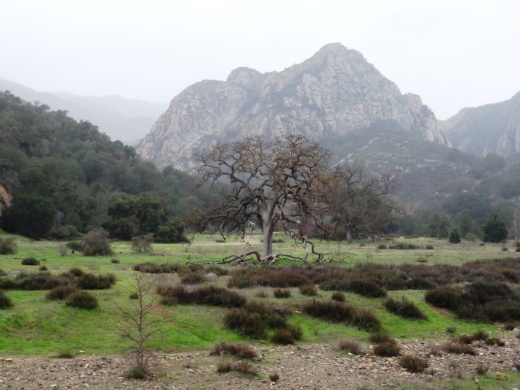
The scenery along the Grassland Trail can be quite beautiful, particularly after the rainy season.

The scenery along the Grassland Trail can be quite beautiful, particularly after the rainy season.

MalibuCreekSP_020815.JPG
MalibuCreek_CragsRoadSign.JPG

Soon you'll see the sign where you can see the Visitor Center is on the left. That's the direction you'll be taking to get to the Rock Pool. Veering to the right gets you to another popular site at the Park, the old M*A*S*H television series set.

You'll see a bridge over the creek (seen below after the winter rains) that takes you to the Visitor Center (open weekends noon to 4pm). The Rock Pool is the trail on the right (west) before reaching the bridge. Look carefully and you may see the little sign that says "Rock Pool."

Malibu Creek free flowing after some decent winter rainstorms

Malibu Creek free flowing after some decent winter rainstorms

Well known Rock Wall used by rock climbers seen in the original Planet of the Apes (1968)

Well known Rock Wall used by rock climbers seen in the original Planet of the Apes (1968)

You'll walk through a shaded area with picnic benches through to a Rock Wall that is popular with local rock climbers. The video above shows scenes from the movie Planet of the Apes (1968) shot in Malibu Creek State Park. From there, the Rock Pool is a short walk further.

MalibuCreek_RockPool.JPG

California State Parks, which manages the Park, warns visitors not to jump or dive into the Rock Pool as it is dangerous. But it is certainly fun to explore and is quite a beautiful area.

RockPool_MalibuCreek.JPG

All told, getting to the Rock Pool is only about 3 miles round trip and worth it. I would put this hike on par with hiking to Paradise Falls in Thousand Oaks' Wildwood Park in terms of ease of access and family enjoyment. Learn more about Malibu Creek State Park at this link.

Jumping and Climbing Options In and Around Ventura County

If your kids are bouncing off the walls around the house and need to jump off some steam, perhaps they need a new environment for jumping and/or climbing in and around Ventura County. Here are some options to consider.

Sky Zone (formerly DojoBoom and Defy) Extreme Air Sports opened at the Janss Marketplace in Thousand Oaks in November 2017, offering over 50,000 square feet of trampolines, launching decks, foam pits, obstacle course and much more.

Sky Zone Trampoline Park is located at 2825 Johnson Drive in east Ventura. Similar to Sky High, Sky Zone offers wall to wall trampolines with open jump sessions, a "SkySlam" court and more.

Boulderdash Indoor Rock Climbing at 880 Hampshire Road, Suite A, Thousand Oaks, is a 10,000 sq ft climbing area with sections ranging from 25 feet to 45 feet tall. Fun for all ages.

An additional Boulderdash Indoor Rock Climbing opened at 2879 Seaborg Avenue, Suite 101, Ventura in January 2019. This facility is also 10,000 sq ft.

The Agoura Hills/Calabasas Community Center at 27040 Malibu Hills Road, Calabasas features, among other things, a 35 foot rock climbing wall. (Center has been closed pending renovations; anticipated to reopen in late fall 2023.)

Santa Barbara Rock Gym is an 8,500 sq ft facility located at 322 State Street, Santa Barbara.

Not for the inexperienced...rock climbing at Westward Beach in Malibu.

Not for the inexperienced...rock climbing at Westward Beach in Malibu.

For more seasoned climbers, there is a sheer cliff used by rock climbers at Westward Beach in Malibu as well as near the Rock Pool at Malibu Creek State Park.

Mount Pinos in the Los Padres National Forest is the Highest Point in Ventura County

At 8,847 feet in elevation, Mount Pinos is the highest point in Ventura County. It is located in the northernmost tip of Ventura County in the Los Padres National Forest, near the Kern County border.

From Thousand Oaks, plan on about a 1 hour, 45 minute, 100 mile drive to get to the Mount Pinos parking area at the "Mt. Pinos Nordic Base," where you will find plenty of parking. The Base is at an elevation of 8,300 feet, which means you only have 547 feet of elevation gain to hike to the peak.

Plenty of parking available here at Mt. Pinos Nordic Base. The trail to the summit is to the left.

Plenty of parking available here at Mt. Pinos Nordic Base. The trail to the summit is to the left.

The hike to the top is about two miles along a wide access road shaded by pine trees much of the way. It is a fairly easy hike, with no significant challenges. Easy enough for kids and adults alike, though at this elevation your breathing may be a bit more labored than normal.

Take a deep breath of fresh air as you experience the 50th highest and 11th most topographically prominent summit in California.

Trail to the Mt. Pinos summit is largely tree-lined. You may trip on a pine cone or two!

You will notice a radio tower up ahead with about a 1/2 mile to go to the peak. You will come across a fork in the road. Turn right to get to the actual peak. Continue towards the left (west) for a Chumash interpretative area.

At this juncture of the trail, you will notice a radio tower up ahead at the summit of Mt. Pinos

The interpretative area has several benches and an interpretative sign. The Chumash name for Mount Pinos is Iwihinmu. The Chumash call the summit Liyikshup, the center of the world.

A view from Mount Pinos summit.

Of course, you'll find snow up here in the winter months.  There are no ski lifts, but cross country skiing, tubing and snow play are available....right here in Ventura County.

You may also find stargazers situated in the parking lot with high powered telescopes.

There are campgrounds available on Mount Pinos, including the following:

Directions to Mount Pinos: From I-5, take Frazier Park exit (Frazier Mountain Park Road). Go west approximately 6 miles. The road name changes to Cuddy Valley Road. Continue on it up Mt. Pinos. The road name changes to Mt. Pinos Highway.

Check traffic and weather conditions before you go, particularly during snow season. Good to have chains on hand.

Frazier Mountain Community Snow Play Visitor Page at www.facebook.com/groups/2579680555601233

Squawkless in Summerland? No! Check Out the Santa Barbara Bird Sanctuary

It was not a planned visit.

My son and I were cycling from Carpinteria to Santa Barbara for the first time, enjoying a relaxing ride on Via Real/Lillie Ave, paralleling the 101 on the north side.

We passed a sign that said "McLeod Parrot Menagerie" and I heard birds, squawking birds. I said, let's check this out! 

Little did I know that co-located at the Menagerie is the Santa Barbara Bird Sanctuary.

Squawkless in Summerland!? Heck no! Lots of squawking and talking going on at this place!

The Sanctuary is a non-profit organization founded by Jamie McLeod that rescues and rehabilitates parrots that are unwanted, abused and orphaned. The organization also finds homes for these beautiful animals. 

The Sanctuary is home to over 60 of birds, some of which are ready for adoption; others may have conditions that prevent adoption.

We got the chance to chat with Jamie, who is 1984 graduate from the America's Teaching Zoo at Moorpark College. She showed us the Skylar Learning Center, where children can learn more about these interesting, long-lived, intelligent creatures.

And of course we visited with the birds and had meaningful conversations with many of them. We heard words and phrases like "hello," "knock knock," "how's it going," "I love you," and so on. Quite entertaining. And we caught a few cool head bobs too!

We also learned that the McLeod Parrot Menagerie provides grooming and boarding, toys and other parrot-related products and services.

The Santa Barbara Bird Sanctuary is a must see and less than an hour from central Thousand Oaks. Walk-in visits are available 10 am to 3:30 pm Mondays, Wednesdays, Fridays, Saturdays and Sundays. Fees for non-docent tours are $10 for adults and $5 for 12 and under and 65+ seniors. Donations are welcomed (and tax deductible) as they help towards caring for and feeding the parrots. Docent-led personalized tours are also available with at least one week’s advance notice. You may observe the birds, but do not touch or feed them or their cages.

These fellows were quite entertaining.

These fellows were quite entertaining.

To learn more, visit www.sbbird.org or visit their Facebook page at www.facebook.com/sbbsbirds or call 805.565.1807. The street address is 2340 Lillie Avenue, Summerland.