Ventura County Historical Landmarks at the Strathearn Historical Park in Simi Valley

Located at 137 Strathearn Place, Simi Valley, the six acre Strathearn Historical Park and Museum site contains no less than six designated Ventura County Historical Landmarks.

Originally from Scotland, the Strathearn Family purchased 15,000 acres of old Spanish Rancho from Simi Land and Water Co. around 1890.

The Simi Adobe/Strathearn House is Ventura County Historical Landmark No. 6, State Landmark No. 979 and is also listed on the National Register of Historic Places.  The Simi Adobe was originally built by Santiago Pico, original grantee of El Rancho Simi, in 1810. The Adobe was considered an important link between the San Fernando and Ventura missions.

The Strathearn House (built in 1892-3) includes the Simi Adobe (built in 1810)

After buying the property, the Strathearns built their nine-room Victorian-style farmhouse and kept two usable rooms of the adobe that were used as a dining room and kitchen. The Strathearn family occupied the house until 1968.

Built in 1930, the original Simi Library was located on Third Street near Los Angeles Avenue. Members of the community raised funds to purchase land and asked the Ventura County Library System to build this first purpose-built branch library in the county. It operated until 1962, when a new library opened on Church Street in the Community Center. The Simi Library briefly served as the first Simi Valley Museum until Strathearn Historical Park opened in 1969. The Library was designated Ventura County Historical Landmark No. 40 in May 1978. (More recently, in the Simi Valley Public Library became a separate municipal public library on July 1, 2013.)

The Haigh/Talley Colony House was designated Ventura County Historical Landmark No. 41 in May 1978 and was named to the National Register of Historic Places that same year. It is one of 12 pre-cut, partially assembled two-story homes shipped by rail in 1888 to the townsite of "Simiopolis" (this was just for six months; it was later

Read More

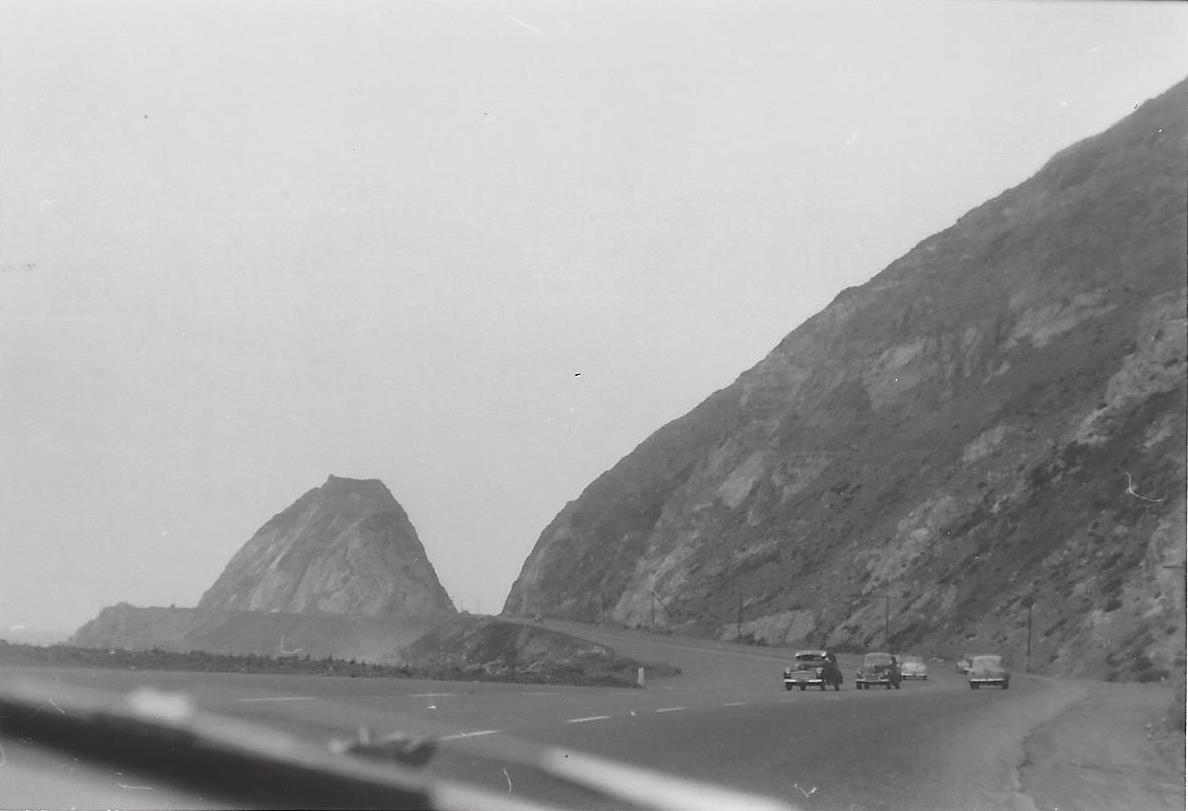
Northbound PCH Just South of Mugu Rock: 1950 and 2019

Mugu Rock came into existence in 1940 when a 200 foot cut was made into the mountain. Today it is an iconic scene that is often seen in auto commercials.

Taken on July 2, 1950, this is a view of Mugu Rock from the shoulder of northbound Pacific Coast Highway (SR 1). From a private collection. And below it is the same view, remarkably similar, 69 years later, on April 20, 2019. Thankfully, some things never change.

Mugu Rock 7.2.50.jpg
Mugu Rock 4.20.19.JPG

Lewis Road Pedestrian Overcrossing in Agoura Hills

This is the Lewis Road Pedestrian Overcrossing, Caltrans Bridge #53-998, in Agoura Hills. It connects Roadside Drive at Lewis Road on the south to Canwood Street at Lewis Road on the north side of the 101. It was built in 1963 and expanded in 1973.

This is the only pedestrian bridge going over a freeway in the Conejo Valley. There is another pedestrian bridge in Thousand Oaks - the Luedtke Bridge over Olsen Road that connects the CLU main campus to the northern campus.

Building Pacific Coast Highway Around Point Mugu in 1923-1924

Point Mugu before and after creation of a narrow road around it in 1924.

Point Mugu before and after creation of a narrow road around it in 1924.

According to the California Highway Commission in the October 1924 issue of “California Highways,” perhaps the most dangerous and difficult piece of construction work on the California state highway system at that time was the 3800 feet of grading AROUND Point Mugu.

For those driving Pacific Coast Highway in Ventura County past Mugu Rock, there are clear signs of this old route that took automobiles on a precarious route around Point Mugu.

Peaking through the fence towards the old road around Mugu Rock.

Peaking through the fence towards the old road around Mugu Rock.

The new and still existing route was created by blasting a massive hole through Point Mugu to create Mugu Rock in 1937 to 1940.

The work to complete this section of the Oxnard to San Juan Capistrano PCH route was authorized by a bond issue in 1919.

The project averaged 60 workers who moved 108,000 cubic yards or rock at a total cost of $108,500 (heck, that would be the cost of a pool addition and new kitchen remodel today). The cut around Point Mugu ranged from 40 feet on the ocean side to 115 feet on the high side in creating the narrow, short-lived roadway.

The California Highway Commission ended its article by stating “…along this piece of rugged coast line the Old Pacific is recognized as an arch enemy to whom we must trust as little as possible of our costly highway.”

Mugu Rock at Point Mugu

Point Mugu is an unincorporated part of Ventura County that is derived from the Chumash word Muwu, or beach. Other than the Naval Base, probably the most well known fixture in Point Mugu is the Mugu Rock. Mugu Rock is a large rock formation that was formed when Pacific Coast Highway was built and cut through the mountain that now resides on the other side of PCH. Before PCH was built, a road went around the rock, where a chain link fence has been placed to keep people away from this hazardous area adjacent to the Pacific Ocean.  PCH was cut through Point Mugu from October 1937 to February 1940, according to this interesting KCET article.

MuguRock_pch.JPG

Mugu Rock is located just a few miles near the northwest tip of PCH before it veers north towards Oxnard. It is about a 10 mile drive from the Camarillo Premium Outlets and about 20 miles from the heart of Thousand Oaks taking either the 101/Lewis Road route or the slightly slower, curvy and interesting Potrero Road route.

Professional landscape and wildlife photographer Greg Clure of Newbury Park has shared a couple neat images facing Mugu Rock from the south. Visit Greg's website at www.gregclurephotography.com for more of his outstanding work.

ClureMuguRock2.jpg
ClureMuguRock1.jpg

And here is some not so professional video footage of Mugu Rock from the north.

The History of Lake Sherwood

Lake Sherwood as seen from the Sandstone Peak trail in the Santa Monica Mountains.

Lake Sherwood as seen from the Sandstone Peak trail in the Santa Monica Mountains.

Lake Sherwood is an unincorporated community of about 1,500 residents in Ventura County overlooking the Lake Sherwood reservoir. It is south of Thousand Oaks and west of Westlake Village, off of Potrero Road,  accessible via Westlake Boulevard on the east and Wendy Drive and Reino Road in Newbury Park on the west.

For centuries, the Conejo Valley was inhabited by the Chumash. The Spanish came into the picture in the late 18th century and, when passing through what is now Hidden Valley, named the area the Potrero Valley.

The Potrero Valley was part of the original 48,761 acres constituting Rancho El Conejo. After California became the 31st state in 1850, a land commission was appointed to determine who owned land grants in the area.

Rancho El Conejo was sold in 1872 to John Edwards and Howard Mills. Mills received 22,240 acres that included the Potrero Valley in 1874. Mills sold the southeastern 8,476 acres to Joseph and Isabell McLaren Howard in 1875.

Photo of the Howard Ranch in the 1880s. The Howard residence was near where Triunfo Park is today in Westlake Village. (Courtesy of Conejo Through the Lens Collection; Thousand Oaks Library Special Collections.)

Photo of the Howard Ranch in the 1880s. The Howard residence was near where Triunfo Park is today in Westlake Village. (Courtesy of Conejo Through the Lens Collection; Thousand Oaks Library Special Collections.)

In 1888, the Howards sold the land to the Banning Company of Long Beach. In 1896, W. H. Matthiessen bought the Potrero Ranch from Banning. Then in 1904, Matthiessen built a 45 foot dam (originally called Alturas Dam) that created Potrero Lake (also referred to as Lake Matthiessen). Total capacity of the 156 acre lake, which today is called Lake Sherwood, is 877 million gallons of water.

In the early 1920s, the area around the lake was transformed into Sherwood Forest for the filming of Robin Hood, featuring Douglas Fairbanks. And of course that's where the name Lake Sherwood originated.

Meanwhile, W. H.'s son F. W. "Christy" Matthiessen married Elsie Mack in 1917. The couple made plans to develop the surrounding area as the Las Turas Lake Club in the 1920s. Except...they divorced in 1925, with Elsie receiving the portion of the ranch with the lake.

Elsie remarried. Her new husband's name was James Canterbury and briefly the lake became Lake Canterbury. After the stock market crash of 1929, the Canterburys sold the property to William Randolph Hearst. Hearst allowed the property to be used for filming of many films, including the 1938 The Adventures of Robin Hood.

In 1963, Dayton Realty purchased the lake and surrounding property. Dayton wanted to rezone the land to develop nearly 1,400 homes and commercial properties. This plan was fought off by local residents and rejected by the Ventura County Board of Supervisors.

From late 1983 to summer 1984, Dayton drained the lake, indicating that it needed to test the dam...which never happened...then never refilled the lake, leaving thousands of fish stranded and left to die in the mud. (Photo of draining of lake in January 1984)

Lake Sherwood was made available to the public after the depression of the 1930s until the lake was emptied in 1984.

A view of Lake Sherwood from the north off of Lake Sherwood Drive.

A view of Lake Sherwood from the north off of Lake Sherwood Drive.

In 1985, billionaire businessman David Murdock bought the dry Lake Sherwood lake bed and surrounding property.  His Ventura Farms and Lake Sherwood Ranch are on the old F. W. Matthiessen property in Hidden Valley.

In 1986, heavy rains filled Lake Sherwood back up, though it would take many years for the lake to regain the wildlife it lost after it was emptied.

Murdock developed the community with over 650 homes in three gated neighborhoods along with the Sherwood Country Club and Sherwood Lake Club. The lake is now privately owned and is not open to the general public. 

Mugu Rock Then and Now

Mugu Rock is a large rock formation formed when a 200 foot deep cut was made into the rocky ridge from October 1937 to February 1940. Prior to the modern day PCH at Mugu Rock (at the time called U.S. 101 Alternate (State Route 60), drivers went around a 275 foot radius curve that is now fenced off.

The photos in the video above from the October 1940 edition of California Highways and Public Works show what it looked like before, during and after the cut was made, compared to what it looks like today.