Powerline Trail to Edison Road to Conejo Mountain Peak in Newbury Park

View of Boney Mountain range from midway up the Powerline Trail in Newbury Park.

View of Boney Mountain range from midway up the Powerline Trail in Newbury Park.

While you're driving down the Conejo Grade from the Conejo Valley towards Camarillo, you may wonder what that mountain is south of the 101.  This would be the 1,814 foot tall Conejo Mountain.

So how do you get up there? 

There are no "official" marked trails to the peak of Conejo Mountain, but there are unofficial ways to get up there. One way that I'm aware of us via the Powerline Trail to Edison Road Trail in the Dos Vientos section of Newbury Park. 

Get to the Powerline Trail trailhead located on Via Ricardo, west of Via Pisa. Park on the street. Or for added trail mileage, park at Dos Vientos Community Park and take the short (1/2 mile) Park View Trail until it ends at Via Ricardo, where you'll see a crosswalk to the Powerline Trail on the other side.

Follow the Powerline Trail on a single to double tract trail until it reaches the much wider Edison Conejo Mountain Road, marked by sets of power line transmission towers.

It is amazing how quiet it can get back here. This trail is a bit on the long, steep side and the mountain can get quite brown and barren. But the rock formations are pretty cool, and get more interesting the higher you climb. And the views are outstanding, from Boney Mountain to the south to the Channel Islands and Oxnard Plain to the west and Thousand Oaks to the east.

You will be passing by this anxiety-causing sign on the way up. Not to worry. Just a warning.

You will be passing by this anxiety-causing sign on the way up. Not to worry. Just a warning.

Now, pay attention, To find the path to the top of Conejo Mountain, count the pairs of transmission towers that you pass. The unmarked path is just above the 4th set of transmission towers, which is roughly two miles from the trailhead.

When I went, there was fairly large arrow formed with rocks that pointed in the direction of the path. Although it is not an official trail, you can kind of make out the path that has been cleared by hikers over the years. And there are some sections where it appears the path has been aligned by rocks.

In any case, although it looks difficult, it actually isn't that bad, as long as you take your time and watch your step. When you reach the top, you will have a clear birds eye view of the 101 on the other side.of the mountain.

When it greens up after the winter storms, it sure looks a lot prettier up here.

When it greens up after the winter storms, it sure looks a lot prettier up here.

A clear view of Highway 101 from the peak of Conejo Mountain.

A clear view of Highway 101 from the peak of Conejo Mountain.

Clear, unimpeded views of Anacapa and Santa Cruz Islands from up here.

Clear, unimpeded views of Anacapa and Santa Cruz Islands from up here.

Two Views From Conejo Valley Trails the Weekend of February 10-11, 2018

We're lacking rain this winter in Southern California once again (last year was a different story) so our trails in the Conejo Valley aren't as green as they should be in mid-February. But nonetheless, they are still beautiful. Here are a couple views this weekend; one from the Potrero Ridge Trail and the other from the Rosewood Trail in Newbury Park.

For over 50 over trails and hikes throughout Ventura County and adjacent areas, visit THIS LINK.

View From Grant Park in Ventura and Serra Cross in January 1956

Panoramic view from Grant Park in Ventura in three photos taken in January 1956.

Panoramic view from Grant Park in Ventura in three photos taken in January 1956.

Here's a panoramic view from Grant Park in Ventura taken in January 1956. Shortly after Father Junipero Serra founded Mission San Buenaventura, a large wooden cross was placed on top of the hill overlooking the Mission church.

The original cross, damaged over time by the elements, was replaced in the 1860s. That cross blew down in a storm on November 5, 1875 and was not replaced for 40 years.

The cross at Grant Park / Serra Cross Park in 2015.

The cross at Grant Park / Serra Cross Park in 2015.

A new wooden cross was placed by a local women's service club on September 9, 1912. In 1918, Kenneth and Tonie Grant donated the surrounding hillside to the City of San Buenaventura. Roads to the cross were built around 1920. The circular stone pedestal and concrete pathway the cross now sits atop was built in March 1932. The cross that sits there today, a bit charred from the Thomas Fire, was replaced by the city in 1941.

The Serra Cross Conservancy is seeking donations at www.gofundme.com/serracrosshelp to help restore the cross and surrounding property.

Serra Cross in January 1956, from a private collection.

Serra Cross in January 1956, from a private collection.

Grant Park in Ventura is a No Brainer for Panoramic Views of the Coast

GrantParkView1_0515.jpg

The 107 acre Grant Park is easily accessible from Downtown Ventura via Brakey Road or Summit Drive in Ventura and is a quick and easy way to get your dose of coastal views. There's no playground, restrooms, water or other facilities at this park. But there's plenty of open space and scenery below.

GrantParkView2_0515.jpg

The view looking the opposite direction of the Pacific Ocean, over the western-most section residential section of Ventura.Several other notable items at Grant Park are the privately owned Serra Cross Park and the Ventura Botanical Gardens Demonstration Trail.

You can spend 10 minutes up here for a quick dose of views or you could spend half a day up here resting, hiking, picnicking and enjoying the ocean breezes.

At the very, very top of Grant Park is this lone bench.

At the very, very top of Grant Park is this lone bench.

Spring Flowers and Green Hills at Charmlee Wilderness Park in Malibu

View of Zuma Beach to Point Dume State Beach from Charmlee Wilderness Park.

View of Zuma Beach to Point Dume State Beach from Charmlee Wilderness Park.

Charmlee Wilderness Park, a 532 acre park at 2577 Encinal Canyon Road in Malibu, is a "must visit" for anyone who lives in the local area. Located in the Santa Monica Mountains, its eight miles of trails dispersed through 532 acres of land provide unbelievable spectacular views of Zuma Beach to Point Dume in particular.

The Park is also blossoming with wildflowers and is green as can be in March 2017 after our significant winter rainstorms.

Park hours are 8 a.m. to sunset and the nature center is open on weekends from 8 a.m. to 5 p.m. (or dark, whichever comes first). Parking is $4.

Green envelopes the trains here in early March 2017.

Green envelopes the trains here in early March 2017.

From Charmlee, I noticed this beautiful flower display on a hilltop home and had to take a pic and post it to Instagram. Little did I know that this is apparently Caitlyn Jenner's hilltop home.

From Charmlee, I noticed this beautiful flower display on a hilltop home and had to take a pic and post it to Instagram. Little did I know that this is apparently Caitlyn Jenner's hilltop home.

Charmlee2017_4.JPG

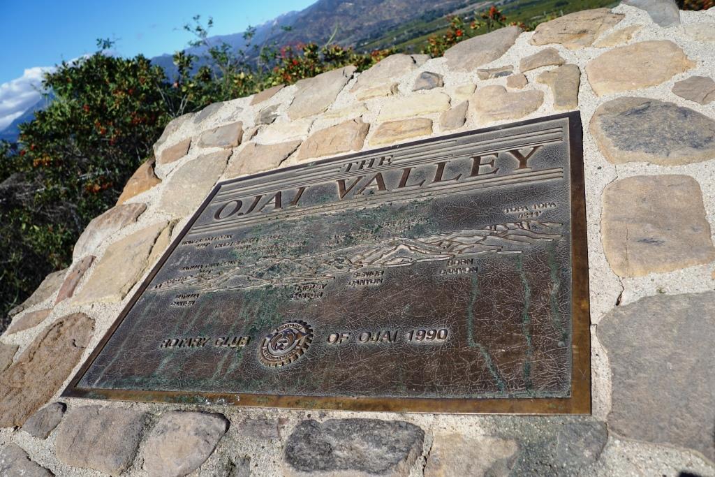
The Ojai Valley Sign and Rotary Club of Ojai Plaque on State Route 150

The Ojai Valley sign on California State Route 150 at 6462 Santa Paula Ojai Road.

The Ojai Valley sign on California State Route 150 at 6462 Santa Paula Ojai Road.

California State Route 150 runs 36.4 miles, from State Route 126 in Santa Paula at 10th Street (where it is called Ojai-Santa Paula Road), through Ojai (where it is called Ojai Avenue), then co-signed with State Route 33 (Maricopa Highway) until unincorporated community Meiners Oaks, then Baldwin Road between Ojai and Lake Casitas, then finally, Casitas Pass Road until it ends at U.S. Route 101 in Carpinteria.

If you are driving the section between Ojai and Santa Paula (which you WILL have to do sometime to experience the beauty back there), at roughly 6462 N. Ojai Road you will see a large "The Ojai Valley" monument.

Park the car, check out the views of the Ojai Valley and take a look at the Rotary Club of Ojai plaque dated 1990. The plaque shows various prominent mountain peaks in the Ojai Valley, including:

  • White Ledge Peak (4,640')
  • Matilija Twin Peaks (4,485')
  • Three Sisters Peaks (5,378')
  • Nordhoff Peak (4,485')
  • Chief Peak (5,334')
  • Topatopa Peak (6,244')

The plaque also highlights the canyons in view - Matilija Canyon, Gridley Canyon, Senior Canyon and Horn Canyon.

VISIT THIS PAGE FOR A BUNCH OF FUN THINGS TO DO IN OJAI

OjaiRotaryPlaque1990.JPG
As you can see, the view is awesome. The tallest point ahead is Chief Peak.

As you can see, the view is awesome. The tallest point ahead is Chief Peak.

This photo was taken in January 2017 after storms dusted snow on the Topa Topa Mountains. We can see this snow from the Conejo Valley but it is fun to see it closer up from Ojai.

This photo was taken in January 2017 after storms dusted snow on the Topa Topa Mountains. We can see this snow from the Conejo Valley but it is fun to see it closer up from Ojai.

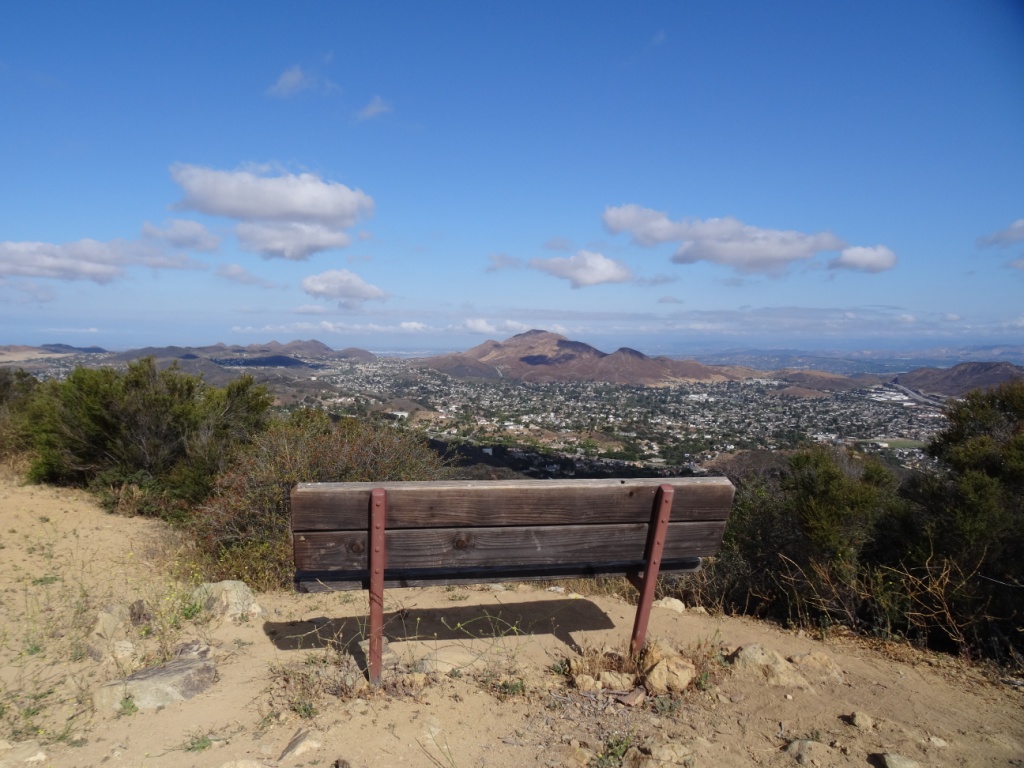
The Bench to the East of Angel Vista Peak in the Conejo Open Space

The 1,530 foot Angel Vista in Newbury Park may well have the most spectacular views of the Conejo Valley. Angel Vista can be accessed via the Rosewood Trail off of Lynn Road (just west of Regal Oak Ct) or the Los Robles Trail (either the Thousand Oaks side accessible at South Moorpark Road and Greenmeadow Ave or Newbury Park side off of Potrero Road).

The unforgetable view from the Angel Vista Peak bench, facing towards the Conejo Grade

The unforgetable view from the Angel Vista Peak bench, facing towards the Conejo Grade

There is a slightly higher peak steps away from Angel Vista Peak that with a bench that has panoramic views that stretch from Hidden Valley to Boney Mountain to the Conejo Valley.

Facing southeast from Angel Peak, head up this short, moderately steep trail.

Facing southeast from Angel Peak, head up this short, moderately steep trail.

And soon you will see this secluded, old looking bench at the top of the hill.

And soon you will see this secluded, old looking bench at the top of the hill.

A sturdy bench it is, that has withstood the test of time...and the unfortunate etchings of vandals.

A sturdy bench it is, that has withstood the test of time...and the unfortunate etchings of vandals.

AngelVista_EastPeakBench.JPG
The view looking straight ahead into the Conejo Valley

The view looking straight ahead into the Conejo Valley

The view towards Hidden Valley

The view towards Hidden Valley