Two Ventura County Cities Were Born on September 29, 1964!

You wouldn't immediately know it looking at the headline of this September 30, 1964 issue of The Daily News, but the day before, residents in BOTH Camarillo and Thousand Oaks voted to incorporate their respective cities.

The article indicates that voters in Camarillo voted in favor of incorporation by a 5 to 1 margin, with 64% of the 3,745 registered voters turning in ballots. In the far right column, you'll see that with 10 of 18 precincts counted, 61% of 2,428 votes cast in Thousand Oaks were for incorporation. In Thousand Oaks they also voted on the name of the city...over 87% of votes cast said "yes" to the name Thousand Oaks.

Thanks to the Pleasant Valley Historical Society Museum in Camarillo for maintaining this and other local Ventura County history!

CamarilloTOaksIncorp2.jpg

SKA-teen Roller Rink in Thousand Oaks From 1967 to 1983

ska-teen1.JPG

Back in the day, there was a roller rink at 300 Hampshire Road in Thousand Oaks, across the street from the former K-Mart. It was called the SKA-teen Roller Rink. It opened in 1967 and closed in 1983.

Twelve years later, Roller Dome opened at 950 Avenida de Los Arboles in Thousand Oaks in 1995, where it operated until October 2010.

Now the only remaining roller rink in Ventura County is Skating Plus in Ventura.

ICE SKATING, ROLLER SKATING AND SKATEBOARDING OPTIONS IN VENTURA COUNTY

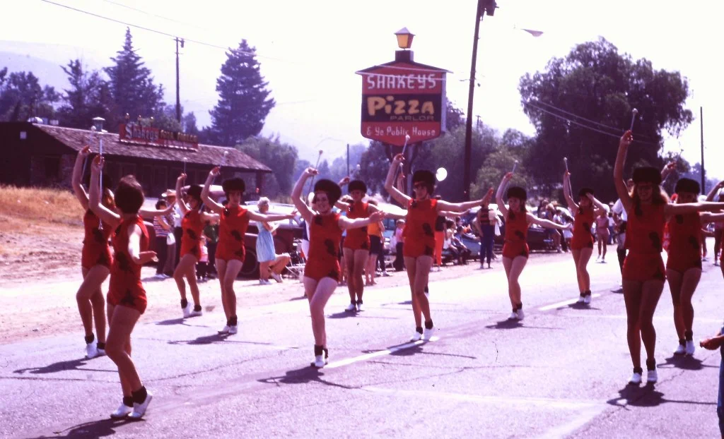
Shakey's Pizza Parlor on Thousand Oaks Boulevard in the 1960s

Shakey's Pizza Parlor in the background at the 1966 Conejo Valley Days Parade

Shakey's Pizza Parlor in the background at the 1966 Conejo Valley Days Parade

Back in the day, there were only a few pizza places in Thousand Oaks, including this Shakey's Pizza Parlor on the north side of Thousand Oaks Boulevard, located across the street from Jungleland (where the Thousand Oaks Civic Arts Plaza now resides). 

The exact address of Shakey's was 2361 Thousand Oaks Blvd., where Toyota of Thousand Oaks resides today.

Today we have more pizza choices than ever imagined in the Conejo Valley. Over the last several years, newcomers to the Conejo Valley pizza scene include:

To name a few...not to mention Toppers Pizza, Winner’s Pizza, D’Amore’s Pizza, Butler's Pizza, California Pizza Kitchen, Pizzeria La Piccola (now closed), Tony's Pizza, Greco's Pizzeria, Parma Pizza and many others.

Shakey's Pizza was founded in Sacramento on April 30, 1954, by Sherwood "Shakey" Johnson and Ed Plummer. Johnson's nickname resulted from nerve damage following a bout of malaria suffered during World War II.  In the 1970s, there were approximately 500 Shakey's locations in the U.S. Today there are 54, the majority of which are still here in Southern California. The closest Shakey's to Thousand Oaks is 30 miles away, in Northridge.

Another scene from the 1966 Conejo Valley Days Parade. Miss Shakey's is absent! But Miss Sizzler is present!

Another scene from the 1966 Conejo Valley Days Parade. Miss Shakey's is absent! But Miss Sizzler is present!

Hike to the Danielson Monument in the Boney Mountain Wilderness

One of the more popular and challenging hikes in the local area takes you from the Rancho Sierra Vista/Satwiwa Recreation Area in Newbury Park to the Danielson Monument in the Boney Mountain Wilderness (Point Mugu State Park). 

It is about 5.5 miles round trip and has a net elevation gain of about 600 feet. The Monument is close to 1,500 feet in elevation This is a fairly challenging trail as roughly two thirds of the hike you are going up and down fairly substantial hills. That said, I've seen hundreds of folks on these trails of all fitness levels and ages doing it at their own pace.

Entrance into Rancho Sierra Vista/Satwiwa at Lynn Road and Via Goleta in Newbury Park

Entrance into Rancho Sierra Vista/Satwiwa at Lynn Road and Via Goleta in Newbury Park

Starting at the Satwiwa Native American Culture Center, make your way to the Danielson Road trail by either taking the Big Sycamore Canyon Fire Road (paved) south for roughly .3 mile and then a left on Danielson Road (trail) or take the Satwiwa Loop Trail that runs diagonally southeast until you reach a fork on the trail.

(Note: You can also park at the trailhead at Wendy and Potrero Roads and add another few miles to your trek.)

Sycamore Canyon Road southbound towards Point Mugu State Park from Satwiwa Center

Sycamore Canyon Road southbound towards Point Mugu State Park from Satwiwa Center

Veer right (south) at the juncture of the Danielson Road and Satwiwa Loop trails towards a bench that overlooks Sycamore Canyon. This is called the Upper Sycamore Canyon Overlook.

The bench at the Upper Sycamore Canyon Overlook in Rancho Sierra Vista

The bench at the Upper Sycamore Canyon Overlook in Rancho Sierra Vista

The short, rocky trail eastbound from there (behind the bench) takes you to another fork, where you can either veer left to the Hidden Valley Overlook trail (part of Rancho Sierra Vista/Satwiwa) or right into the Boney Mountain Wilderness. (Note that dogs and bikes are not allowed in the Boney Mountain Wilderness.)

Entering the Boney Mountain Wilderness

Entering the Boney Mountain Wilderness

After a steady descent of about another .4 mile, you'll see another sign. Continue towards the left. On the right is the Upper Sycamore Canyon Trail, kind of a fun, winding trail at the bottom of the canyon. Save that for another day.

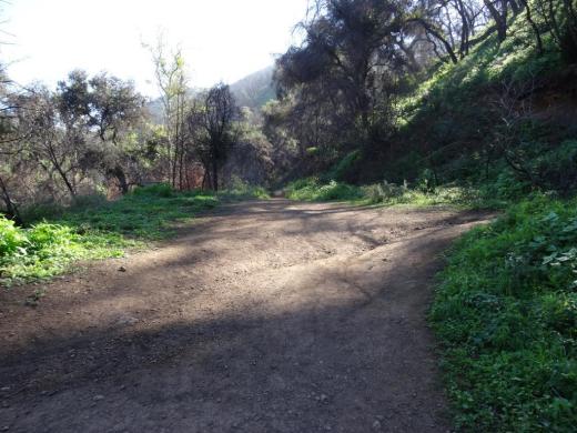
In non-drought years, there is often a creek you may need to walk through as you continue on Danielson Road. It has been years since the stream was of any significance but it was back in February 2017 after recent rainstorms. But it is generally easy to get across.

After navigating the narrowest portion of trail, you will see a juncture. The unmarked "Waterfall Trail" is straight ahead (only about 120 steps to the "Waterfall" when there's not a severe drought). You can check it out as it is such a short distance. But to get to the Monument, veer sharply right, continuing up Danielson Road.

Juncture of Waterfall (straight ahead) and Danielson Road (to the right)

Juncture of Waterfall (straight ahead) and Danielson Road (to the right)

This is a long, grinding, uphill trail of about a mile until you get to a juncture where you can make a right-hand turn to the Old Boney Trail. As you make your way up, you'll be treated to great views from Sycamore Canyon to Newbury Park and beyond.

This is a bit of a dried out view from Upper Danielson Road looking down from where we came from in 2015.

This is a bit of a dried out view from Upper Danielson Road looking down from where we came from in 2015.

You're almost there once you see this Old Boney trail sign - just .3 mile to go

You're almost there once you see this Old Boney trail sign - just .3 mile to go

Continue straight on Danielson Road. There are some areas coming up that periodically get overgrown. Watch out for poison oak particularly in these areas, continuing on to the Monument. In .3 mile, you're reached your destination.

The Danielson Monument is a tribute to Richard Ely Danielson, Junior who lived on the 7,800 acre Rancho Sierra Vista after purchasing the land from the estate of Carl H. Beal in 1947 for roughly $500,000. Danielson lived on the ranch for over three decades with his family. He donated 5,585 acres of the ranch to the State of California, which became part of Point Mugu State Park, and sold 850 acres, including the horse ranch, to the National Park Service in 1980.  He passed away on December 27, 1988. 

Ranching in the area dates back to the early 1800s, when Spanish soldiers were granted 48,672 acres of land, "Rancho El Conejo," which through the years was subdivided and sold to other landowners. One of these ranchers was Carl Beal, who in 1937 named the area Rancho Sierra Vista "Mountain View Ranch." 

The Monument is in a peaceful setting, surrounded by trees. And it stays fairly green up here. A good place to eat lunch or sit and relax. Adjacent to the Monument is a remnant of Danielson's cabin - the chimney. If you continue up this path to the right, you can get to the top of Boney Mountain.

Remnant of Danielson's cabin adjacent to the monument - a chimney.

Remnant of Danielson's cabin adjacent to the monument - a chimney.

One thing I've never seen in my decades on this particular trail are strollers. I think strollers would be a bit of a challenge for many due to rocky and narrow sections, periodic overgrowth and poison oak on the sides of a small portion of the trail and, when we're not in a drought, a stream crossing. 

COMPILATION OF TRAILS IN AND AROUND VENTURA COUNTY

Neptune's Net and County Line Beach in Malibu are Local-Area "Must Do's"

NeptunesNetJune2016.jpg

Neptune's Net is a Malibu icon, located across from County Line Beach in Malibu at 42505 Pacific Coast Highway. Everyone who lives in the local area just has to experience this favorite eatery overlooking the Pacific. 

Originally built in 1956, the location of the fryer and grill have not changed. However, it was originally a gas station, real estate office and restaurant called "Panorama Pacific at Solimar" but locals called it Jake's Diner (after Eastman "Jake" Jacobs, its owner). In 1974 it was sold and the new owners renamed it Neptune's Net. The current owners purchased it in 1991.

Some of our favorites at Neptune's Net are everything fried (fish & chips, shrimp, scallops, clam strips and calamari), fresh seafood (lobster, crab, shrimp and oysters), burgers and more. Quite a popular biker hangout but at the same time, family friendly.

If you're newbie, check out the menu and then find the back of the ordering line, which often stretches back to the refrigerated drinks area. Grab your drink first as you wait in line. Order. Grab a seat, either in the front patio overlooking PCH, the side patio adjacent to the parking lot or the indoor seating area. Learn more at neptunesnet.com.

After (or before) you've dined, park or re-park (it's nice to clear your spot at Neptune's Net for other folks) your car across the street at County Line Beach, a casual, perhaps 1/3 mile stretch of beach surrounded by residences on each side.

There are no facilities at this beach other than three porta-johns in the parking area. No parking fees. 

County Line Beach is popular with surfers and folks generally hanging out and jumping into the water. There are some rocks to explore on the west side of the beach too. And well-behaved dogs can often be seen at this beach.

Rocks about on the west side of the beach, which stretches around to residences.

Rocks about on the west side of the beach, which stretches around to residences.

Hillside Letters "SP" on South Mountain in Santa Paula

Santa Paula SP 1.JPG

When driving southbound in Santa Paula, look up towards the mountain south of the city (aptly named South Mountain) and you’ll see the letters SP boldly emblazoned high up on the hill that overlooks the Santa Paula Airport.

According to the Santa Paula Times, the letters are 125 feet long and 25 feet wide and originated in the 1922 time frame when a group of high schoolers made the trek up the mountain to carve the letters.

The brush was cleared annually over the years until the 1970s; for decades thereafter, the brush overgrew the letters and made them difficult to see.

Then, as part of the city’s centennial celebration in 2002, the Times noted that Limoneira Co. and other volunteers and donors worked to clean up the letters for all to see.

Santa Paula SP 2.JPG

Santa Paula is not alone in its mountain monogram. Other local area cities with monograms include Agoura Hills (there’s a letter A in the hill north of Agoura High School), the letters CLU emblazoned on the hill overlooking Cal Lutheran University, the letter F in the hills east of Fillmore, the letter V in the hills above Ventura High School and the letters VC in the hills above Ventura College.

Of course, the most prominent icon landscaped into a hill in Ventura County is Happy Face Hill seen by westbound drivers on the 118 near Kuehner Drive.

Happy Face Hill in Simi Valley - sure to bring a smile to your face.

Happy Face Hill in Simi Valley - sure to bring a smile to your face.

Spanish Flu "Do Not Do's" in the 1918 Los Angeles Times

dont kiss her now.jpg

As we know, the COVID-19 pandemic is not the first pandemic we’ve experienced. The 1918 influenza pandemic, called the Spanish flu, was caused by an H1N1 virus that originated in birds. It infected half a billion people, or about a third of the world’s population, between February 1918 to April 1920. It killed between 17 million to as many as 100 million people.

This image from the L.A. Times in December 1928, “Don’t Kiss Her Now!” provided advice to readers. Advice has evolved quite a bit since then during our own pandemic. :)

DON’T DO THESE THINGS

  • Don’t kiss your sweetheart while “Spanish flu” or pneumonic plague is on!

  • You might kill her - or him, by passing a deadly germ along.

KISSING SPREADS FLU

  • Don’t sneeze or cough in anybody’s face. Use your handkerchief to cover nose and mouth.

  • Don’t neglect or laugh at a “common cold.” It may be the first symptom of “flu!”

  • Don’t worry. Worry is weakening.

  • Don’t visit “flu” victims unless you really must do so. Then wear a “flu” mask.

  • Don’t use a common drinking cup anywhere.

  • Don’t use a common towel anywhere.

  • Don’t put pencil or penholder in your mouth. There may be “flu” germs on it!

  • Don’t put money in your mouth. Put it in your pocket.

  • Last but not least…Don’t pet dogs or cats. They carry germs in their hair.

And there you have it.