Thousand Oaks Transit Provides Low Cost Transportation in the Conejo Valley

TOTransit_logo.png

Thousand Oaks Transit (TOT) offers five local bus routes serving the Conejo Valley. One way fares as of May 2023 are $2.00 per ride; 65+ seniors/disabled are $.50 and children 5 and under are free. Transfers from one bus to another are free and must be requested when you purchase your fare.

(NOTE: As of September 2022, all students in grades 1-12 as well as college students ride for free anywhere in Ventura County, with student ID.)

Buses are equipped with free Wi-Fi, security cameras and bike racks. Operating hours are Monday to Friday, 5 a.m. to 8 p.m. and Saturday 7 a.m. to 8 p.m.

TOT buses are equipped with destination signs on the front, side and rear of the bus. Here are the current bus routes:

  • Route 40 Newbury Park - Stops include Newbury Park High School, Borchard Park, Dos Vientos Community Center, The Oaks. 25 total stops.

  • Route 41 Midtown A - Stops include The Oaks, Los Robles Hospital, Cal Lutheran, Thousand Oaks High School, Teen and Senior Centers/T.O. Library, Transportation Center. 18 total stops.

  • Route 42 Midtown B - Stops include The Oaks, Conejo Valley High School, Thousand Oaks High School, Cal Lutheran, Los Robles Hospital, Conejo Valley Plaza, Janss Marketplace. 22 total stops.

  • Route 43 TOB Express - Stops include The Oaks, Transportation Center, City Hall, Westlake High School. 25 total stops.

  • Route 44 Crosstown - Stops include Westlake High School, The Oaks, Amgen. 35 total stops.

Exact fares are required on TOT buses in the form of cash, pass or transfer. Passes can be purchased on buses. Multi-day bus passes are available. Where's the bus? You can track them at www.nextbus.com.

Perhaps the most useful feature is the trip planner at www.toaks.org/departments/public-works/transit/plan-your-trip where you can type your location and destination and you’ll receive a step by step itinerary showing where to catch the bus and how long it takes to get to your destination.

TOTransit1.jpg

The Thousand Oaks Transportation Center located at 265 South Rancho Road (just south of the 101) is a transportation hub for eastern Ventura County.  The Center provides parking for transit users and rideshare participants and connects riders with the four routes described above as well as the following:

  • Several VCTC Intercity bus lines

  • Metro Line 161, which takes riders east with stops in Westlake Village, Agoura Hills, Calabasas, Woodland Hills and Warner Center.

  • LADOT Commuter Express 422 and 423 bus lines operating Monday to Friday as far as Downtown Los Angeles.

TOTransit2.JPG

To learn more, visit www.TOTransit.org or call 805.375.5473. There are bus schedules online, as well as at the Civic Arts Plaza (Public Works Counter on the 1st floor), Thousand Oaks/Newbury Park Libraries, Senior Center, Oaks Mall 2nd Floor Information Desk and at the Transportation Center.

The Giant Sand Dune on PCH Across From Thornhill Broome Beach in Point Mugu

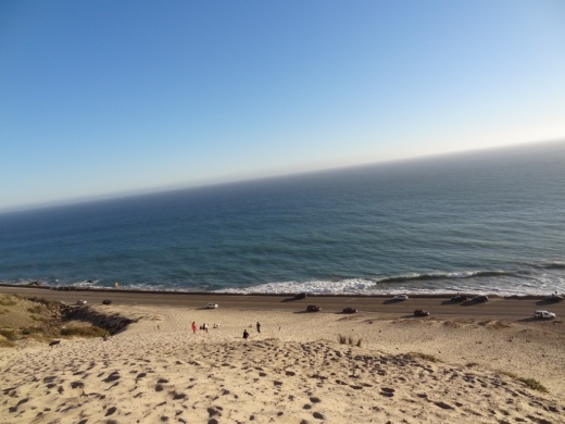
One of the many unique things to see in Ventura County is the gigantic sand dune located on the east end of Thornhill Broome Beach in Point Mugu.

ThornhillSandDune.JPG

Driving north up PCH, you'll see the sand dune on the east side after passing by Sycamore Canyon/Sycamore Cove Beach and before reaching the entrance to the Thornhill Broome Campground. 

ThornhillBroomeDune1.JPG

Park on the shoulder off of PCH. There's plenty of room, though you may be partially parked in the sand. You can also park on the beach side of PCH but rather than taking your life in your hands jaywalking across PCH, you're better off parking on the mountain side of the highway.

The mysteriously large sand dune is the result of "Aeolian transport," or the wind's movement of particles, in this case, sand. Quite steep this hill is, but your effort will be rewarded with some beautiful views of the Pacific Ocean. Plus, you get a nice bird's eye view of Mugu Rock.

ThornhillBroomeDune3.JPG

We noticed that the southern-most portion of the sand dune seems to have more large rocks in the sand from erosion of the mountains above. The northern hill, at least the several times we've now been there since originally posting this, has somewhat less rocks, leaving the sand smoother and more comfortable to walk on.

Going down the hill is certainly a lot easier than coming up!

Elvis Presley "Wheels on My Heels" from "Roustabout" Filmed in Hidden Valley, Thousand Oaks, 1964

The 1964 musical film “Roustabout,” starring Elvis Presley, was filmed at Paramount Studios, with carnival scenes in Thousand Oaks. And there was this scene of Elvis on his Honda 305 Superhawk motorcycle in Hidden Valley, singing “Wheels on my Hills.”

It is remarkable how little has changed in Hidden Valley, 55 years after the Elvis film was shot.

Eateries That Opened in the First Half of 2023 and are Coming Soon to the Conejo Valley and Greater Ventura County

We’re mid-way through 2023 and have already seen several new dozen new eateries opening in the Conejo Valley and nearby areas, with another several dozen working to open in the coming months. See the list below.

New Eateries That Opened in the First Half of 2023

Powerline Trail to Edison Road to Conejo Mountain Peak in Newbury Park

View of Boney Mountain range from midway up the Powerline Trail in Newbury Park.

View of Boney Mountain range from midway up the Powerline Trail in Newbury Park.

While you're driving down the Conejo Grade from the Conejo Valley towards Camarillo, you may wonder what that mountain is south of the 101.  This would be the 1,814 foot tall Conejo Mountain.

So how do you get up there? 

There are no "official" marked trails to the peak of Conejo Mountain, but there are unofficial ways to get up there. One way that I'm aware of us via the Powerline Trail to Edison Road Trail in the Dos Vientos section of Newbury Park. 

Get to the Powerline Trail trailhead located on Via Ricardo, west of Via Pisa. Park on the street. Or for added trail mileage, park at Dos Vientos Community Park and take the short (1/2 mile) Park View Trail until it ends at Via Ricardo, where you'll see a crosswalk to the Powerline Trail on the other side.

Follow the Powerline Trail on a single to double tract trail until it reaches the much wider Edison Conejo Mountain Road, marked by sets of power line transmission towers.

It is amazing how quiet it can get back here. This trail is a bit on the long, steep side and the mountain can get quite brown and barren. But the rock formations are pretty cool, and get more interesting the higher you climb. And the views are outstanding, from Boney Mountain to the south to the Channel Islands and Oxnard Plain to the west and Thousand Oaks to the east.

You will be passing by this anxiety-causing sign on the way up. Not to worry. Just a warning.

You will be passing by this anxiety-causing sign on the way up. Not to worry. Just a warning.

Now, pay attention, To find the path to the top of Conejo Mountain, count the pairs of transmission towers that you pass. The unmarked path is just above the 4th set of transmission towers, which is roughly two miles from the trailhead.

When I went, there was fairly large arrow formed with rocks that pointed in the direction of the path. Although it is not an official trail, you can kind of make out the path that has been cleared by hikers over the years. And there are some sections where it appears the path has been aligned by rocks.

In any case, although it looks difficult, it actually isn't that bad, as long as you take your time and watch your step. When you reach the top, you will have a clear birds eye view of the 101 on the other side.of the mountain.

When it greens up after the winter storms, it sure looks a lot prettier up here.

When it greens up after the winter storms, it sure looks a lot prettier up here.

A clear view of Highway 101 from the peak of Conejo Mountain.

A clear view of Highway 101 from the peak of Conejo Mountain.

Clear, unimpeded views of Anacapa and Santa Cruz Islands from up here.

Clear, unimpeded views of Anacapa and Santa Cruz Islands from up here.

Pick Your Own Produce at Underwood Family Farms in Moorpark

Underwood Sign.JPG

For a fun, inexpensive local family activity, stop by Underwood Family Farms in Moorpark for some "Pick Your Own" fun. Open most of the year, weather and farm conditions permitting. They've got everything from avocados, beans, beets, blackberries, broccoli, carrots, cauliflower, onions, cucumbers, on through spinach, squash and tomatoes, depending on time of year.

Underwood offers pull wagons, bags and containers for you to stash your haul. Then of course you pay for it. And if you can't find what you want in the fields, they may have it in their Farm Market.

  • Weekday Admission: $7 (as of June 2023)

  • Weekend and Holiday Admission: $10 (as of June 2023) (subject to change during spring, fall and Christmas festivals)

  • Children under 2 and parking free.

  • Wagon rides included with admission.

  • Seniors (65+), Military, Veterans and 1st Responders w/ID get $2 off.

Learn more at underwoodfamilyfarms.com/pick-your-own.

Throwback Moment: Price-Costco Store Opened in Westlake Village in August 1996

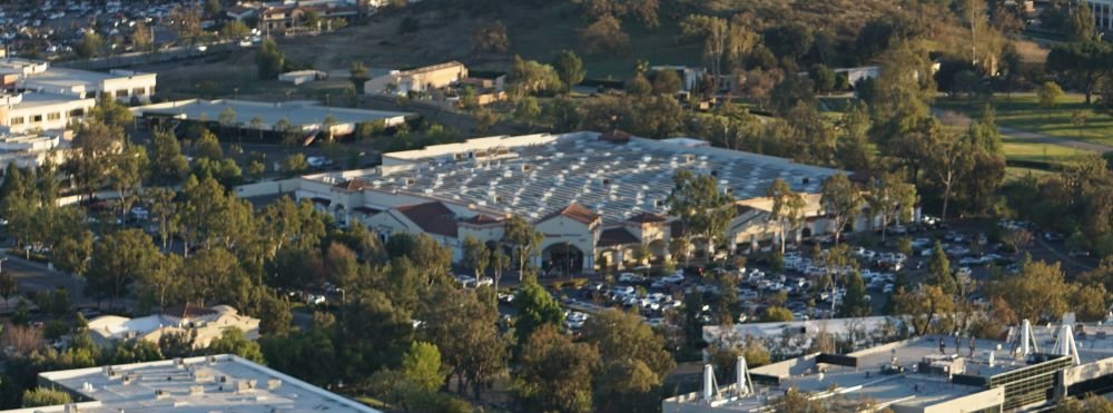
Costco Westlake Village seen from the North Ranch Open Space

Let’s face it…the Westlake Village Costco is one of the most popular places to go in the Conejo Valley. Always teeming with shoppers and sample hunters, it seems the local community would be lost without this store.

Let’s go back in time to when it opened…

The store opened its doors as PriceCostco on Thursday, August 8, 1996 at 5700 Lindero Canyon Road. Price-Costco was formed in 1993 with the merger of Price Club (which opened its first location on July 12, 1976 in San Diego) and Costco (which opened its first warehouse in Seattle on September 15, 1983).

One of my life’s guilty pleasures…the $1.50 Costco Hot Dog  and Soda deal.

One of my guilty pleasures…the $1.50 Costco Hot Dog and Soda deal.

Who remembers PriceCostco? The merger between the two companies took place in 1993. Price Club was being pursued by Walmart to merge with the Sam’s Club warehouse store chain. Price opted to merge with Costco instead. And wallah…PriceCostco was created. At the time, there were 206 locations. As of August 2022, there are 838 Costco locations worldwide.

The prior management team from Price Club, the Price brothers, left the company in 1994 and in 1997, “Price” was dropped from the name and it became Costco.

According to a 1/4/96 VC Star article, PriceCostco purchased the 30 acre site at Lindero Canyon Road and Westlake Boulevard in Westlake Village for $9.3 million, with plans for a 136,000 sq ft Price Club.

Local residents were against the addition of the warehouse club to the community. City Council approved the project as it was allowed as part of a long-term commercial development agreement in place with owners of the property. However, the city stipulated approval was required for specifics like exterior color scheme, roofing materials in earth tone colors, etc.

Flashback to 2009: There were high hopes for a 2nd Conejo Valley Costco location in Newbury Park at the corner of Grande Vista Drive and Academy Drive. But according to a T.O. Acorn article on 1/29/09, Costco could not make the project economically feasible as it was “unable to finalize a lease for the site.”

It is clear that Costco prefers to own its land and buildings, not lease them. In Costco’s annual Form 10-K filing for the fiscal year ended August 29, 2021, fully 79% of its 815 warehouses around the world were owned; the remaining 19% were leased.

Lowe’s and LA Fitness were able to work a deal with owners of the property in Newbury Park and the City of Thousand Oaks Planning Commission approved the project to build locations there at a meeting on 12/13/10. Lowe’s Newbury Park opened on July 4, 2019.