Hillside Letters in the Conejo Valley and Greater Ventura County

There are over 500 hillside letters, or “mountain monograms,” in the United States, including 81 in California. What are hillside letters, you ask. They are simply large single letters, abbreviations and sometimes even messages erected on a hillside, usually by a school or town.

The Big “C” overlooking UC Berkeley (From Wikipedia; public domain)

The Big “C” overlooking UC Berkeley (From Wikipedia; public domain)

One well known hillside letter is a giant concrete block letter “C” built in the hills overlooking UC Berkeley that was constructed on March 23, 1905.

We have our share of hillside letters here in the Conejo Valley and Greater Ventura County, some of which you may be aware of…others, perhaps not.

The mountain monograms visible in our neck of the woods include:

The letters CLU on Mt. Clef Ridge above Cal Lutheran University are maintained by students.

Hilltop A overlooking Agoura High School up a steep hill. Made out of wood, I believe.

Here is a view of the letter VC north of Ventura College in late April 2019.

Here is a view of the letter VC north of Ventura College in late April 2019.

If you drive north up Catalina Street, west of Ventura High School, you will be able to see this letter V on the hillside.

The letter F is located in the hills west of Fillmore and is quite easy to see.

This letters SP letters in the hills south of Santa Paula is cleared brush. They originated in 1922. More information on THIS PAGE.

Happy Face Hill in Simi Valley is not a mountain monogram but is perhaps the visible hillside attraction throughout Ventura County.

Laugh it Up! Live Comedy in and Around Ventura County

iStock_HappyFace.jpg

Looking for laughs around Ventura County? Here are some great options to consider.

Levity Live Comedy Club at The Collection at RiverPark in Oxnard offers a weekly lineup of stand-up comedy. oxnard.levitylive.com

The Hillcrest Center for the Arts hosts “Stand-Up Comedy on the Hill” on designated Saturday nights, hosted by Jason Love. Visit www.hillcrestarts.com for upcoming shows.

The Canyon Club in Agoura Hills is known primarily for music also hosts top-notch comedians. Reserve a dinner table and get guaranteed seating! www.canyonclub.net

The Bank of America Performing Arts Center Thousand Oaks hosts all types of performances...musicals, concerts, lecture, ballet, dances, plays and comedy! bapacthousandoaks.com

Giggles Santa Paula - Live comedy shows with top talent at the Glen Tavern Inn in Santa Paula. www.giggleslive.com/santa-paula

Comedy Nights at the High Street Arts Center in Moorpark on designated Saturday nights posted at highstreetartscenter.com.

Jest Improv is a Ventura-based comedy school that offers shows at the Bunker Theater in Ventura, improv classes, workshops and more. www.jestimprov.com

Funny Girl Events - Local comedian Steph Clark hosts events at various local are venues. More info at www.funnygirlevents.com.

Free Range Comedy is a comedy improv troupe that performs periodic comedy shows throughout Ventura County. www.instagram.com/freerangecomedysocal

Humor No More

The Copa Comedy Club (formerly Ventura Harbor Comedy Club), at Ventura Harbor Village), closed its doors on December 19, 2023.

Cheeseboro Canyon vs Chesebro Road in Agoura Hills

CheeseboroApr18.jpg

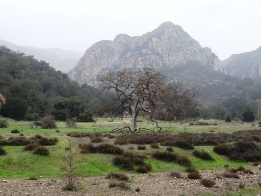
Cheeseboro and Palo Comado Canyons cover over 4,000 acres in the northernmost section of the Santa Monica Mountains National Recreation Area, in the Simi Hills. The Chumash occupied these canyons for thousands of years, until ranchers came into the area in the 1800s. The natural landscape changed as a result to accommodate the needs of grazing cattle.

The National Park Service (NPS) acquired Cheeseboro Canyon in the early to mid 1980s and subsequently acquired Palo Comado Canyon (formerly known as the Jordan Ranch), in 1994.

Nearly every time we post an image from Cheeseboro Canyon to a social media site, someone points out, "it's not Cheeseboro, it's Chesebro."

Why is it called Cheeseboro when the road that gets you to the trailhead is called Chesebro?

According to one NPS Ranger I've spoken with, the original owner of the land in the late 1800s was Oscar Cheesebrough (yet a different spelling). The NPS adopted the U.S. Geological Survey spelling of Cheeseboro, while Caltrans adopted the name Chesebro.

Why the difference? That's not so clear. But what IS clear is that the actual canyon is called Cheeseboro Canyon and it is a beautiful place to hike and bike!

CheeseboroPic1.jpeg
ChesebroSign.jpg

M*A*S*H Site at Malibu Creek State Park

Malibu Creek State Park is a wilderness wonderland, stretching over 8,000 acres in Calabasas, Agoura and Malibu. The park is a great place for hiking, biking, camping, picnicking and exploring. If you do plan to explore the park, be sure to check out the old M*A*S*H (or "MASH" television series set!

MalibuCreek_Mash1.jpg

Produced by 20th Century Fox, M*A*S*H was filmed from September 1972 to February 1983 over 11 seasons and 256 episodes on CBS. Exterior scenes were filmed at what is now Malibu Creek State Park. Over the years, the ambulance and other props left at the old site became less and less visible as the surrounding brush became overgrown.

In 2007, the set was restored with a shaded picnic area, military vehicles, ambulance, helipad and signpost. Check out the photos below, but, better yet, visit it in person! For more pictures and extensive information about the M*A*S*H set and Malibu Creek State Park, visit www.malibucreekstatepark.org.

MASH_sign.jpg

The M*A*S*H site is easily accessible from the main parking lot at Malibu Creek State Park, mostly on wide fire roads, with one significant hill, a bridge crossing and one somewhat rocky trail section. The path is about 2 1/2 miles each way, so it would be a good idea to bring drinks and snacks.

MalibuCreek_Mash2.JPG
MASH_3.JPG
MASH_4.JPG
MashSite4.JPG
MashSite6.JPG

Palo Comado Canyon Trail in Agoura Hills

Palo Comado Canyon is located adjacent to Cheeseboro Canyon in the National Park Service maintained Santa Monica Mountains in Agoura. Palo Comado is part of the 2,308 acre Jordan Ranch owned by comedian Bob Hope that was acquired for $16.7 million in 1993.

The Palo Comado Canyon Trail stretches from the Modelo Trail in Cheeseboro Canyon on the south to the China Flat area in Oak Park to the north, about six miles one way.

View of the Cheeseboro Canyon trailhead and parking are from the Modelo Spur Trail.

View of the Cheeseboro Canyon trailhead and parking are from the Modelo Spur Trail.

There are stretches of the trail that are flat, wide and good for family hikes and outings. This section of the trail is primarily in the area accessible via the Smoketree Avenue (east of Conifer St in Oak Park) and Doubletree Road (east of Clear Haven Dr in Oak Park) residential connectors.

The Palo Comado Trail on the south end connects with the Cheeseboro Canyon Trail in addition to the moderately steep Modelo Trail.

From the main Cheeseboro Canyon Trail, this juncture leads you to the south entry point to the Palo Comado Trail.

From the main Cheeseboro Canyon Trail, this juncture leads you to the south entry point to the Palo Comado Trail.

The Modelo Trail on the south end of the Palo Comado Canyon Trail is a bit steep, with awesome views.

The Modelo Trail on the south end of the Palo Comado Canyon Trail is a bit steep, with awesome views.

The southern section of the Palo Comado Trail has rolling hills with some beautiful views, but is a bit on steep side. The northern section of the trail, about a mile or so above the Doubletree trailhead, is also a moderately grueling climb, from 1,200 feet to 2,140 feet elevation at the China Flat area. In my personal experiences on these sections of the trail, mountain bikers are the vast majority. But don't let that stop you if you're up for a long, mostly quiet, hike!

The southern end of the Palo Comado Trail has rolling, moderately steep hills.

The southern end of the Palo Comado Trail has rolling, moderately steep hills.

Learn more about Cheeseboro/Palo Comado Canyon are at THIS LINK.

Lewis Road Pedestrian Overcrossing in Agoura Hills

This is the Lewis Road Pedestrian Overcrossing, Caltrans Bridge #53-998, in Agoura Hills. It connects Roadside Drive at Lewis Road on the south to Canwood Street at Lewis Road on the north side of the 101. It was built in 1963 and expanded in 1973.

This is the only pedestrian bridge going over a freeway in the Conejo Valley. There is another pedestrian bridge in Thousand Oaks - the Luedtke Bridge over Olsen Road that connects the CLU main campus to the northern campus.

Hike to the Rock Pool at Malibu Creek State Park in Agoura Hills

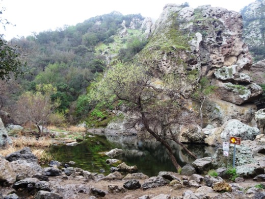
One of the most popular destinations in Malibu Creek State Park is the Rock Pool, a picturesque place that is easily accessible for all ages.

MalibuCreek_RockPool1.JPG

As seen in the photo above, it can be stunning to see after solid rains but can also dry up. One fun way to get to the Rock Pool is via the Grassland Trail, accessible on Mulholland Highway just west of Las Virgenes Road, where street parking is available.

GrasslandTrail_sign.JPG

Take the Grassland trail, with moderate hills, .7 miles to the Crags Road main fire road/trail in Malibu Creek State Park, and turn right. Alternatively, you can park in the Park's lower parking lot, pay $12 for a bit more secure parking, and take the main trail into the park.

The scenery along the Grassland Trail can be quite beautiful, particularly after the rainy season.

The scenery along the Grassland Trail can be quite beautiful, particularly after the rainy season.

MalibuCreekSP_020815.JPG
MalibuCreek_CragsRoadSign.JPG

Soon you'll see the sign where you can see the Visitor Center is on the left. That's the direction you'll be taking to get to the Rock Pool. Veering to the right gets you to another popular site at the Park, the old M*A*S*H television series set.

You'll see a bridge over the creek (seen below after the winter rains) that takes you to the Visitor Center (open weekends noon to 4pm). The Rock Pool is the trail on the right (west) before reaching the bridge. Look carefully and you may see the little sign that says "Rock Pool."

Malibu Creek free flowing after some decent winter rainstorms

Malibu Creek free flowing after some decent winter rainstorms

Well known Rock Wall used by rock climbers seen in the original Planet of the Apes (1968)

Well known Rock Wall used by rock climbers seen in the original Planet of the Apes (1968)

You'll walk through a shaded area with picnic benches through to a Rock Wall that is popular with local rock climbers. The video above shows scenes from the movie Planet of the Apes (1968) shot in Malibu Creek State Park. From there, the Rock Pool is a short walk further.

MalibuCreek_RockPool.JPG

California State Parks, which manages the Park, warns visitors not to jump or dive into the Rock Pool as it is dangerous. But it is certainly fun to explore and is quite a beautiful area.

RockPool_MalibuCreek.JPG

All told, getting to the Rock Pool is only about 3 miles round trip and worth it. I would put this hike on par with hiking to Paradise Falls in Thousand Oaks' Wildwood Park in terms of ease of access and family enjoyment. Learn more about Malibu Creek State Park at this link.