Evolution of the Conejo Grade in Ventura County Over the Last 100 Years

Horseshoe shaped section of the Conejo Grade in the 1920s.

Horseshoe shaped section of the Conejo Grade in the 1920s.

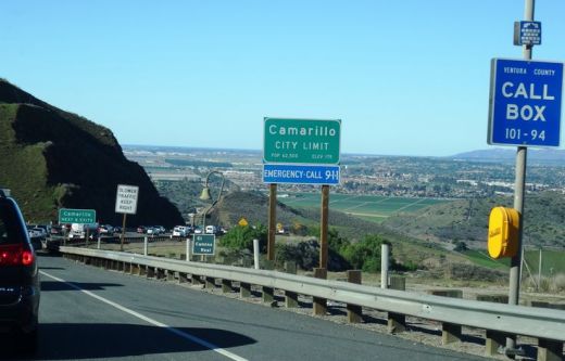
The Conejo Grade is the section of Highway 101 that connects the Conejo Valley with Camarillo. It is a four mile stretch of freeway with a significant 7% grade.

Going down the Conejo Grade from Newbury Park to Camarillo today.

Going down the Conejo Grade from Newbury Park to Camarillo today.

At 3:30 p.m. on the afternoon of May 1, 1937, a newly upgraded and realigned Conejo Grade premiered after a day of celebration commencing at the ranch of Adolfo Camarillo. Camarillo, the namesake of what in 1964 became the City of Camarillo, donated the right of way to enable the grade to be realigned. Actor Leo Carrillo entertained guests at Camarillo's ranch at the bottom of the grade.

Grand opening of the newly realigned Conejo Grade on May 1, 1937.

Grand opening of the newly realigned Conejo Grade on May 1, 1937.

The old Conejo Grade was constructed by the California Highway Commission in 1914-1915. The previous route had 49 twists and turns, making it somewhat hazardous to drive (albeit somewhat less steep than the current grade). The newly aligned Conejo Grade cut the number of curves by 75%.

Another view of the Conejo Grade before it was realigned in 1937.

Another view of the Conejo Grade before it was realigned in 1937.

The new 1937 Conejo Grade cost a total of $570,000, which is less than the average cost of a house in the Conejo Valley today! Over a year and a half, the project employed about 100 workers who put in over 272,000 hours, excavating over 800,000 cubic yards of mostly hard rock. Talk about rock stars!

In the 1950s and 1960s, Caltrans further widened and improved Highway 101 over the Conejo Grade.

In the 1950s and 1960s, Caltrans further widened and improved Highway 101 over the Conejo Grade.

Several decades later, as Ventura County grew and the cities of Camarillo and Thousand Oaks incorporated in 1964, Caltrans continued to widen and improve the highway to what it is today.

ConejoGrade2014_2.jpg

Source for historical information: "California Highways and Public Works" (May 1937) - official journal of the State of California Division of Highways, Department of Public Works.

Special thanks to the Pleasant Valley Historical Society for providing historic photos.

Tell Me a Little Bit About the City of Westlake Village Boundary

Westlake Village is a master-planned community that is transected diagonally by the Los Angeles/Ventura County line. 

The Ventura County side of Westlake Village, which is 8,544 acres, was annexed into the City of Thousand Oaks in 1968 and 1972. The Los Angeles County side of Westlake Village is 3,456 acres and was incorporated as the City of Westlake Village in 1981. 

Westlake Village Map.JPG

Ah yes, the challenge of distinguishing between the Los Angeles and Ventura County sections of Westlake Village. It truly is a diagonal boundary that stretches from just northeast of Lindero Canyon Road, south of Blackbird Avenue on the north to South Westlake Blvd at Kirsten Lee Drive on the south.

It is impossible to drive, bike or walk the boundary line because it crosses right through the middle of Westlake Lake. Although, you could drive along the border on La Venta Drive southwest from Watergate Road.

Further north, the border cuts diagonally across Westlake Golf Course.  In fact, the driving range section of the golf course bordered on the west by Lakeview Canyon Road and on the north by the 101 is located within the City of Thousand Oaks while the rest of the course is in Westlake Village.

Costco Westlake Village and the Four Seasons Westlake Village are solely part of the City of Westlake Village, as is the Las Virgenes Reservoir.

Does it really matter what side you're on? For most, no. But there's one clear financial difference. Sales taxes. As of July 2024, sales taxes in the Thousand Oaks/Ventura County portion of Westlake Village are 7.25% as compared to 9.5% in the Los Angeles County based City of Westlake Village. The difference is 2.25% for Los Angeles County district taxes. That means if you live in the City of Westlake Village, you’ll be paying $1,125 more for a $50,000 car than those living in the Ventura County portion of Westlake Village.

Las Virgenes Reservoir, the only body of water lying completely in the City of Westlake Village.

Las Virgenes Reservoir, the only body of water lying completely in the City of Westlake Village.

U.S. National Park Service Free Entrance Days

NationalParkService.jpg

There are over 400 national parks covering over 84 million acres throughout the United States and its territories.  The majority of these parks do not charge entrance fees (though parking fees often apply). As for the roughly 110 national parks that do have entrance fees, there are a number of designated "fee free" days each year.

Here are the National Park Service Free Entrance Days in 2024:

  • January 15 (Martin Luther King Jr. Day)

  • April 20 (First Day of National Park Week)

  • June 19: (Juneteenth National Independence Day)

  • August 4 (Anniversary of the Great American Outdoors Act)

  • September 28 (National Public Lands Day)

  • November 11 (Veterans Day)

The parks that normally charge a fee that are free on the above dates are listed at www.nps.gov/findapark/feefreeparksbystate.htm. California parks in this category include:

Plenty of other amazing national treasures are on this list, like Grand Canyon National Park.

And of course there are two national parks in Ventura County that are always worth exploring:

For more information about the National Park Service, visit www.nps.gov.

Areas in the Santa Monica Mountains Recreation Area Allowing Dogs on Leash

Pooch on leash

Pooch on leash

The Santa Monica Mountains National Recreation Area is the largest urban national park in the United States at over 150,000 acres, extending from the Hollywood Bowl on the east to Point Mugu at its western end; including the beaches of Santa Monica and Malibu as well as the canyons and peaks extending north to Simi Valley.

Dogs are allowed in a number of areas within the Santa Monica Mountains, as long as they are on leashes that are no more than 6 feet in length. Here is a listing of areas where dogs are allowed:

National Park Service: Arroyo Sequit (has been closed since the Woolsey Fire in 2018), Castro Crest, Cheeseboro/Palo Comado Canyons, Circle X Ranch, Deer Creek Canyon, Paramount Ranch, Peter Strauss Ranch, Rancho Sierra Vista/Satwiwa, Rocky Oaks, Solstice Canyon and Zuma/Trancas Canyons

Santa Monica Mountains Conservancy: Calabasas Peak, Dixie Canyon, Escondido Canyon, Franklin Canyon, Fryman Canyon, Marvin Braude Mulholland Gateway Park, Red Rock Canyon Park, San Vicente Mountain Park, Temescal Gateway Park, Wilacre Park

City of Malibu: Charmlee Wilderness Park, Malibu Bluffs

California State Parks: Pets are NOT allowed on backcountry trails of Topanga, Malibu Creek, Leo Carrillo and Point Mugu State Park, including the Boney Mountain Wilderness.

Canines are not allowed in the backcountry trails of Point Mugu State Park, including the Boney Mountain Wilderness.

Canines are not allowed in the backcountry trails of Point Mugu State Park, including the Boney Mountain Wilderness.

Dogs on leash are allowed at County Line Beach, Leo Carrillo State Park (on beach north of lifeguard tower 3 and campground only), Point Mugu State Park (on beach and campground only in Sycamore Cove and Thornhill Broome Beach), Will Rogers State Historic Park (day-use areas and loop road only)

L.A. City Recreation and Park District: Coldwater Canyon Park, Laurel Canyon Park, Runyon Canyon Park, Temescal Canyon Park

While you're out on the trails with your pooch, remember to pick up after your dog and bring plenty of water and food for you and Fido.

For more information, visit the Anthony C. Beilenson Interagency Visitor Center in Calabasas or www.nps.gov/samo.

Outside of the Santa Monica Mountains, trails in the Conejo Valley, Simi Hills and other local area locations are generally dog-friendly as long as your furry friend is on a leash. 

Dozens and dozens and dozens of local area trails and hikes

DOG PARKS IN AND AROUND VENTURA COUNTY

VISITING STATE PARKS WITH YOUR DOG

Mugu Rock at Point Mugu

Point Mugu is an unincorporated part of Ventura County that is derived from the Chumash word Muwu, or beach. Other than the Naval Base, probably the most well known fixture in Point Mugu is the Mugu Rock. Mugu Rock is a large rock formation that was formed when Pacific Coast Highway was built and cut through the mountain that now resides on the other side of PCH. Before PCH was built, a road went around the rock, where a chain link fence has been placed to keep people away from this hazardous area adjacent to the Pacific Ocean.  PCH was cut through Point Mugu from October 1937 to February 1940, according to this interesting KCET article.

MuguRock_pch.JPG

Mugu Rock is located just a few miles near the northwest tip of PCH before it veers north towards Oxnard. It is about a 10 mile drive from the Camarillo Premium Outlets and about 20 miles from the heart of Thousand Oaks taking either the 101/Lewis Road route or the slightly slower, curvy and interesting Potrero Road route.

Professional landscape and wildlife photographer Greg Clure of Newbury Park has shared a couple neat images facing Mugu Rock from the south. Visit Greg's website at www.gregclurephotography.com for more of his outstanding work.

ClureMuguRock2.jpg
ClureMuguRock1.jpg

And here is some not so professional video footage of Mugu Rock from the north.

Bank of America "Museums on Us" Program Offers Free Admission to Over 225 Museums Nationwide

MuseumsOnUs.jpg

If you are a Bank of America or Merrill Lynch customer, your bank credit or debit card and photo ID will gain you one free admission to over 225 cultural institutions across the country on the first full weekend of each month. Visit the "Museums on Us" program website at museums.bankofamerica.com for details.

And while there are no Ventura County museums on the list, there are a number of other choices within driving range:

  • Autry National Center of the American West

  • Los Angeles County Museum of Art

  • Skirball Cultural Center

  • Museum of Latin American Art in Long Beach (Saturdays only)

  • Discovery Science Center, DiscoveryCube Orange County (Sundays only)

  • Santa Barbara Museum of Art

  • MOXI, The Wolf Museum of Exploration + Innovation in Santa Barbara

Free admission is limited to individual cardholder at participating institutions.

Digitally Preview Your Mail Each Morning with USPS Informed Delivery

Informed Delivery by USPS allows you to preview your mail each morning with a digital copy of each letter-sized item to be delivered to you via email. You can also log in anytime and see images of previous week’s mail. Additionally, you can see the delivery status of any packages coming your way.

If you’ve ever had your mail stolen, this gives you the ability to at least see what mail was stolen from you. Or you can see first thing in the morning what mail is being delivered, alerting you to anything of particular importance.

You will see the address side of mail delivered. You of course will not be seeing contents of that mail.

Learn more and sign up at informeddelivery.usps.com.