Visit the Camarillo Ranch House for a Taste of Local Ventura County History
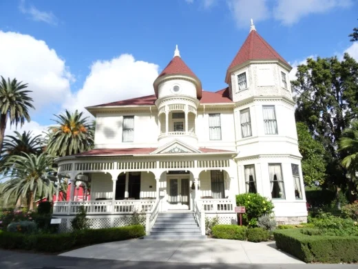
Built in 1892, the Camarillo Ranch House is a grand, three-story, 15-room home built by Adolfo Camarillo in the Queen Anne Victorian style. It was named to the National Register of Historic Places in February 2003. The home features seven bedrooms, a grand staircase, tower bay, wooden refrigerator, wrap-around exterior balcony, hardwood floors and turrets.

The exterior and interior of the Camarillo Ranch House were restored by the City of Camarillo and Camarillo Ranch Foundation in 1999-2001.

CamRanch_1.JPG

The White Horse Stables were built in 1966 for the famed Camarillo White Horses. Breeding of the horses began in 1920 when Adolfo Camarillo acquired Sultan, a Spanish stallion, and bred him with a Morgan mare. The White Horses are now owned by members of the White Horse Association. Learn more about the White Horses at www.camarillowhitehorses.org.

Renovation of the historic 1905 Mule Barn at the Camarillo Ranch was completed in 2009.

CamRanch_barn.JPG

Today the Camarillo Ranch is owned by the City of Camarillo and operated by the Camarillo Ranch Foundation. The Camarillo Ranch House operates as a museum, featuring rotating exhibits, along with historic home and school tours.

The 3 1/2 acre site is host to a number of community events each year and is available to private parties for weddings, parties, fundraisers and other events. It is a beautiful setting, shaded by historic trees planted before 1900.  You can't miss these trees as you drive by on the 101 freeway.

CamRanch_trees.JPG

Docent-led tours of the house are currently (as of September 202) offered on Saturdays and Sunday from 11 a.m. to 2 p.m. (last tour starts at 1:30 p.m.). House tour fees are $5 per person (cash only). Children 12 and under are free. The grounds are open every day from 9 a.m. to 5 p.m. and are open to the public.

The Camarillo Ranch House is located at 201 Camarillo Ranch Road.  Visit camarilloranchfoundation.com or call 805.389.8182 for more information.

CamRanch5.JPG

The Old "Agoura" Sign on Agoura Road

AgouraSign_Lewis.jpg

I was running (literally running) around Agoura Hills, in the vicinity of Agoura Road west of Chesebro Road, when I looked up and saw this distinctly vintage "Agoura" sign displayed at the corner of Agoura and Lewis Roads. While I've driven that stretch of Agoura Road hundreds of times over the years, for whatever reason I never really noticed this interesting sign.

AgouraSigncloseup.JPG

I wondered how long this sign has been there. City of Agoura Historian Cim Castellon was able to help put some of the puzzle together by contacting Brian Rooney of R7 Media, who provided the image below.

This photo shows two women posing for the camera with the Agoura sign and Agoura Market and Gas Station, owned by Harold Neale, in the background.

Photo Credit: R7 Media (www.r7media.com)

Photo Credit: R7 Media (www.r7media.com)

On the east side of Lewis Road road is the old Agoura Post Office at 28249 Agoura Road, Agoura Hills. Brian thinks the Agoura sign was put up about the time the post office opened.

CenterStageMusic.JPG

The sign is located adjacent to what used to be Center Stage Music, in a building that originally was Fitzgerald's Market in the 1920s and later Agoura Market in the 1940s.

For more local history, be sure to stop by the Reyes Adobe Historical Site, the first home built in Agoura Hills back in 1850.

A Compilation of Automotive Relics in the Open Space of the Conejo Valley

As a resident of the Conejo Valley for over 20 years, a long distance runner and a father with active kids, I've run, walked, hiked and rolled over thousands of miles of trails within and surrounding the Conejo Valley.

Over the years I've noticed interesting, old items on the sides of the trails. These relics from the past always make me wonder how they got there and why they remain. I've attempted here to document these automotive blasts to the past on the trails of the Conejo Valley.

Read More

City of Fillmore Neon-Lighted Sign From Pre-World War II

You don't see many signs around town like the Fillmore sign at the northeast corner of Highway 126 (E. Telegraph Road) and Central Avenue.

Fillmore sign photo taken as I was waiting at the stoplight driving south on Central Avenue.

Fillmore sign photo taken as I was waiting at the stoplight driving south on Central Avenue.

The sign was originally constructed in 1940, making it 80 years old. It is designated a historical landmark by the City of Fillmore.

The Fillmore sign is a cool green neon lit up at night

The Fillmore sign is a cool green neon lit up at night

It's not exactly easy getting to Fillmore from the Conejo Valley as you either have to take the winding path of the 23/Grimes Canyon Road via Moorpark or drive out to Ventura via the 101 and take the 126 to Fillmore by way of Santa Paula. Kind of a haul but certainly fun to do every now and then.

At a total area of only 2.8 square miles, Fillmore is the smallest of Ventura County's 10 cities, and its population of roughly 16,000 places it 9th (roughly double the population of Ojai). Fillmore was not named after Millard Fillmore; it was named after Jerome Fillmore, General Superintendent of the Southern Pacific Railroad when they built the line connecting Santa Paula, Fillmore and Castaic.

Quite a quaint little place that is certainly fun to visit, with highlights such as numerous themed train rides at Fillmore & Western Railway, State Fish Hatchery and Railroad Visitor Center, along with an old town feel along Central Avenue.

Fillmore sign as of July 2022

Sunset View From Tarantula Hill on a Cold February Evening, 2-22-22

Yes, today is 2-22-22, a day that kind of reminds me of 11-11-11. It was a cold, cloudy day and while we did not see rain, we anticipate some showers tonight. In any case, enjoy these photos of tonight’s cloudy sunset from Tarantula Hill in Thousand Oaks.

Ray Miller Trail at Pt. Mugu State Park in Malibu

Views from the Ray Miller Trail at Pt. Mugu State Park.

Views from the Ray Miller Trail at Pt. Mugu State Park.

The Ray Miller Trail is located in the La Jolla Canyon section of Pt. Mugu State Park in Malibu. The trail is named after Ray Miller, "Guardian of the Canyon," who was the first official California State Park Camp Host, having volunteered from March 1, 1979 until his death on April 28, 1989.

Monument to Ray Miller on boulder in the La Jolla Canyon Day Use parking lot.

Monument to Ray Miller on boulder in the La Jolla Canyon Day Use parking lot.

On its own, the trail is 2.7 miles each direction, taking you from the base of La Jolla Canyon to an overlook of the Pacific Ocean that provides sweeping views towards Mugu Rock on the west and Sycamore Cove on the east.

La Jolla Canyon sign in need of repair in September 2015.

La Jolla Canyon sign in need of repair in September 2015.

The trail looks harder than what it really is in my opinion. The elevation gain is close to 1,000 feet over the 2.7 miles, but none of the climbs are particularly steep.  The trail zigs and zags its way up as you take in views below. You will love this trail. Many people I know say this is their favorite trail!

Ray Miller Trail Trailhead Sign
Single track trail all the way up, but the surface is pretty good overall. Can get slippery when wet, however.

Single track trail all the way up, but the surface is pretty good overall. Can get slippery when wet, however.

After you reach the overlook, you continue on until you reach the Overlook Fire Road at the end of the trail (there's a sign). At that point, you can turn back or you can continue on the fire road going either north towards the La Jolla Valley Fire Road, or south towards Sycamore Campground.

Views are in abundance most of the way up this trail. This photo was taken in September 2015, in the midst of a four-year drought. It will green up in the winter.

Views are in abundance most of the way up this trail. This photo was taken in September 2015, in the midst of a four-year drought. It will green up in the winter.

This is the sign indicating you're reached the endpoint of the Ray Miller Trail, where it intersects with the Overlook Fire Road. Explore the road going both directions if you have time (and are carrying water), as there's plenty of views in all dir…

This is the sign indicating you're reached the endpoint of the Ray Miller Trail, where it intersects with the Overlook Fire Road. Explore the road going both directions if you have time (and are carrying water), as there's plenty of views in all directions.

At the bottom of La Jolla Canyon is a group campground.  

La Jolla Canyon is located at 9000 Pacific Coast Highway in Malibu. Take PCH south/southeast from Los Posas Road in Camarillo. Takes about 30 minutes to get there from the center of Thousand Oaks via either the 101 or via Potrero Road in Newbury Park. It is located just east of Mugu Rock and near Thornhill Broome Beach.

You can park in the La Jolla Day Use Parking Lot (as of September 2015, $8 for day use; $7 for seniors), or you can park on PCH and walk in. Dogs and bikes are not allowed on this trail, though horses are. It can get pretty hot up here in the summer, so be careful and bring plenty of water and wear sunscreen. 

The La Jolla Canyon Trail, accessed adjacent to the Ray Miller Trail, has been closed since January 2015 due to mudslides and rain damage. However, you can access the beautiful La Jolla Valley from the the La Jolla Valley Fire Road.

More information about Pt. Mugu State Park

Other local hikes and trails