The Giant Sand Dune on PCH Across From Thornhill Broome Beach in Point Mugu

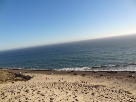
One of the many unique things to see in Ventura County is the gigantic sand dune located on the east end of Thornhill Broome Beach in Point Mugu.

ThornhillSandDune.JPG

Driving north up PCH, you'll see the sand dune on the east side after passing by Sycamore Canyon/Sycamore Cove Beach and before reaching the entrance to the Thornhill Broome Campground. 

ThornhillBroomeDune1.JPG

Park on the shoulder off of PCH. There's plenty of room, though you may be partially parked in the sand. You can also park on the beach side of PCH but rather than taking your life in your hands jaywalking across PCH, you're better off parking on the mountain side of the highway.

The mysteriously large sand dune is the result of "Aeolian transport," or the wind's movement of particles, in this case, sand. Quite steep this hill is, but your effort will be rewarded with some beautiful views of the Pacific Ocean. Plus, you get a nice bird's eye view of Mugu Rock.

ThornhillBroomeDune3.JPG

We noticed that the southern-most portion of the sand dune seems to have more large rocks in the sand from erosion of the mountains above. The northern hill, at least the several times we've now been there since originally posting this, has somewhat less rocks, leaving the sand smoother and more comfortable to walk on.

Going down the hill is certainly a lot easier than coming up!

Powerline Trail to Edison Road to Conejo Mountain Peak in Newbury Park

View of Boney Mountain range from midway up the Powerline Trail in Newbury Park.

View of Boney Mountain range from midway up the Powerline Trail in Newbury Park.

While you're driving down the Conejo Grade from the Conejo Valley towards Camarillo, you may wonder what that mountain is south of the 101.  This would be the 1,814 foot tall Conejo Mountain.

So how do you get up there? 

There are no "official" marked trails to the peak of Conejo Mountain, but there are unofficial ways to get up there. One way that I'm aware of us via the Powerline Trail to Edison Road Trail in the Dos Vientos section of Newbury Park. 

Get to the Powerline Trail trailhead located on Via Ricardo, west of Via Pisa. Park on the street. Or for added trail mileage, park at Dos Vientos Community Park and take the short (1/2 mile) Park View Trail until it ends at Via Ricardo, where you'll see a crosswalk to the Powerline Trail on the other side.

Follow the Powerline Trail on a single to double tract trail until it reaches the much wider Edison Conejo Mountain Road, marked by sets of power line transmission towers.

It is amazing how quiet it can get back here. This trail is a bit on the long, steep side and the mountain can get quite brown and barren. But the rock formations are pretty cool, and get more interesting the higher you climb. And the views are outstanding, from Boney Mountain to the south to the Channel Islands and Oxnard Plain to the west and Thousand Oaks to the east.

You will be passing by this anxiety-causing sign on the way up. Not to worry. Just a warning.

You will be passing by this anxiety-causing sign on the way up. Not to worry. Just a warning.

Now, pay attention, To find the path to the top of Conejo Mountain, count the pairs of transmission towers that you pass. The unmarked path is just above the 4th set of transmission towers, which is roughly two miles from the trailhead.

When I went, there was fairly large arrow formed with rocks that pointed in the direction of the path. Although it is not an official trail, you can kind of make out the path that has been cleared by hikers over the years. And there are some sections where it appears the path has been aligned by rocks.

In any case, although it looks difficult, it actually isn't that bad, as long as you take your time and watch your step. When you reach the top, you will have a clear birds eye view of the 101 on the other side.of the mountain.

When it greens up after the winter storms, it sure looks a lot prettier up here.

When it greens up after the winter storms, it sure looks a lot prettier up here.

A clear view of Highway 101 from the peak of Conejo Mountain.

A clear view of Highway 101 from the peak of Conejo Mountain.

Clear, unimpeded views of Anacapa and Santa Cruz Islands from up here.

Clear, unimpeded views of Anacapa and Santa Cruz Islands from up here.

Pick Your Own Produce at Underwood Family Farms in Moorpark

Underwood Sign.JPG

For a fun, inexpensive local family activity, stop by Underwood Family Farms in Moorpark for some "Pick Your Own" fun. Open most of the year, weather and farm conditions permitting. They've got everything from avocados, beans, beets, blackberries, broccoli, carrots, cauliflower, onions, cucumbers, on through spinach, squash and tomatoes, depending on time of year.

Underwood offers pull wagons, bags and containers for you to stash your haul. Then of course you pay for it. And if you can't find what you want in the fields, they may have it in their Farm Market.

  • Weekday Admission: $7 (as of June 2023)

  • Weekend and Holiday Admission: $10 (as of June 2023) (subject to change during spring, fall and Christmas festivals)

  • Children under 2 and parking free.

  • Wagon rides included with admission.

  • Seniors (65+), Military, Veterans and 1st Responders w/ID get $2 off.

Learn more at underwoodfamilyfarms.com/pick-your-own.

Caspar Borchard and Family Have a Permanent Presence in the Conejo Valley

Caspar Borchard was born in 1842 in Werxhausen, Germany. He sailed to the U.S. with his uncle Christian Borchard in 1867. He liked it so much here that he went back to Germany to get funds (Bitcoin wasn't around back then apparently) to buy land. While back in Germany, he married Theresa Diedrich, who died 3 years later. Within a year he married Theresa Maring. They came back to the U.S. and he bought 205 acres in what is now El Rio (Oxnard).

In 1882, Caspar bought 3,285 acres in the Conejo Valley after his brother Johannes bought 4,000 acres. Theresa Maring died in 1898 at age 49. Their youngest daughter (8 total kids) was also named Theresa. Caspar retired in 1918 and died in 1930. leaving a large family and a permanent presence in the Conejo Valley (Borchard Road, Borchard Park and Community Center). Theresa Drive parallels Borchard from Wendy to Sequoia Middle School in Newbury Park.

This is an undated photo from Thousand Oaks Library archives. Pictured: Back row: Caspar, Rosa, Mary, and Leo. Middle row: Frank, Theresa Maring, holding Charles, Caspar holding Theresa, Antone.

This is an undated photo from Thousand Oaks Library archives. Pictured: Back row: Caspar, Rosa, Mary, and Leo. Middle row: Frank, Theresa Maring, holding Charles, Caspar holding Theresa, Antone.

Hike to the Rock Pool at Malibu Creek State Park in Agoura Hills

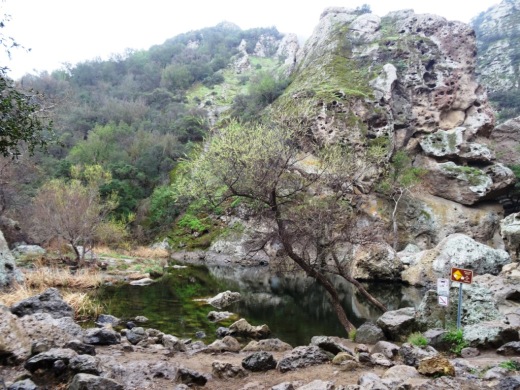
One of the most popular destinations in Malibu Creek State Park is the Rock Pool, a picturesque place that is easily accessible for all ages.

MalibuCreek_RockPool1.JPG

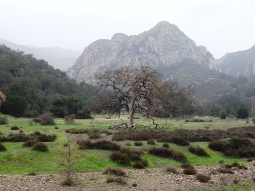
As seen in the photo above, it can be stunning to see after solid rains but can also dry up. One fun way to get to the Rock Pool is via the Grassland Trail, accessible on Mulholland Highway just west of Las Virgenes Road, where street parking is available.

GrasslandTrail_sign.JPG

Take the Grassland trail, with moderate hills, .7 miles to the Crags Road main fire road/trail in Malibu Creek State Park, and turn right. Alternatively, you can park in the Park's lower parking lot, pay $12 for a bit more secure parking, and take the main trail into the park.

The scenery along the Grassland Trail can be quite beautiful, particularly after the rainy season.

The scenery along the Grassland Trail can be quite beautiful, particularly after the rainy season.

MalibuCreekSP_020815.JPG
MalibuCreek_CragsRoadSign.JPG

Soon you'll see the sign where you can see the Visitor Center is on the left. That's the direction you'll be taking to get to the Rock Pool. Veering to the right gets you to another popular site at the Park, the old M*A*S*H television series set.

You'll see a bridge over the creek (seen below after the winter rains) that takes you to the Visitor Center (open weekends noon to 4pm). The Rock Pool is the trail on the right (west) before reaching the bridge. Look carefully and you may see the little sign that says "Rock Pool."

Malibu Creek free flowing after some decent winter rainstorms

Malibu Creek free flowing after some decent winter rainstorms

Well known Rock Wall used by rock climbers seen in the original Planet of the Apes (1968)

Well known Rock Wall used by rock climbers seen in the original Planet of the Apes (1968)

You'll walk through a shaded area with picnic benches through to a Rock Wall that is popular with local rock climbers. The video above shows scenes from the movie Planet of the Apes (1968) shot in Malibu Creek State Park. From there, the Rock Pool is a short walk further.

MalibuCreek_RockPool.JPG

California State Parks, which manages the Park, warns visitors not to jump or dive into the Rock Pool as it is dangerous. But it is certainly fun to explore and is quite a beautiful area.

RockPool_MalibuCreek.JPG

All told, getting to the Rock Pool is only about 3 miles round trip and worth it. I would put this hike on par with hiking to Paradise Falls in Thousand Oaks' Wildwood Park in terms of ease of access and family enjoyment. Learn more about Malibu Creek State Park at this link.

Jumping and Climbing Options In and Around Ventura County

If your kids are bouncing off the walls around the house and need to jump off some steam, perhaps they need a new environment for jumping and/or climbing in and around Ventura County. Here are some options to consider.

Sky Zone (formerly DojoBoom and Defy) Extreme Air Sports opened at the Janss Marketplace in Thousand Oaks in November 2017, offering over 50,000 square feet of trampolines, launching decks, foam pits, obstacle course and much more.

Sky Zone Trampoline Park is located at 2825 Johnson Drive in east Ventura. Similar to Sky High, Sky Zone offers wall to wall trampolines with open jump sessions, a "SkySlam" court and more.

Boulderdash Indoor Rock Climbing at 880 Hampshire Road, Suite A, Thousand Oaks, is a 10,000 sq ft climbing area with sections ranging from 25 feet to 45 feet tall. Fun for all ages.

An additional Boulderdash Indoor Rock Climbing opened at 2879 Seaborg Avenue, Suite 101, Ventura in January 2019. This facility is also 10,000 sq ft.

The Agoura Hills/Calabasas Community Center at 27040 Malibu Hills Road, Calabasas features, among other things, a 35 foot rock climbing wall. (Center has been closed pending renovations; anticipated to reopen in late fall 2023.)

Santa Barbara Rock Gym is an 8,500 sq ft facility located at 322 State Street, Santa Barbara.

Not for the inexperienced...rock climbing at Westward Beach in Malibu.

Not for the inexperienced...rock climbing at Westward Beach in Malibu.

For more seasoned climbers, there is a sheer cliff used by rock climbers at Westward Beach in Malibu as well as near the Rock Pool at Malibu Creek State Park.

Fruit, Vegetable and Other Food, Beer and Wine Festivals In and Around Ventura County

According to the California Department of Food & Agriculture, in 2021, California’s 69,000 farms and ranches generated $51.1 billion in revenue and was the largest producer of commodities in the country, producing 11.8% of the U.S. total. The top ten commodities in the state in 2021 were dairy products, grapes, almonds, cattle, pistachios, lettuce, tomatoes, walnuts, rice and chi

Ventura County ranks 26th out of 58 California counties in geographic size but in 2021 ranked 10th overall in terms of agricultural output, producing nearly $2 billion worth of strawberries, lemons, horiculture, raspberries and other commodities.

All that produce grown in Ventura County (as well as Santa Barbara County) and the hard work that goes into it must explain why we have so many nearby food related festivals and celebrations year-round! Specific dates each year are posted in the Local Events and Events Calendar sections of the site but here's a compilation for you to, ahem, digest. We also opted to include beer, wine and other long-standing festivals for your imbibing pleasure.

The Rotary Club of Thousand Oaks Chili Cook-Off is in the late April to early May time frame each year. It is a charitable fundraiser that has taken place since 1977.

The California Strawberry Festival takes place on the 3rd weekend of May each year. This popular event has taken place since 1984. Up until 2020 the event took place in Oxnard. For the first time in 2023, the festival moved to the Ventura County Fairgrounds.

The Soroptimist International of the Conejo hosts an annual "Margarita Mixoff" event in Thousand Oaks. For many years, the event took place in May. Since 2021, including the 21st annual event in 2023, the event has taken place in September.

The Ojai Wine Festival takes place in the June time frame at Lake Casitas has been around since 1987. They say over 5,000 people attend the event! The 35th annual event will take place in June 2023.

The Knights of Columbus of Simi Valley has been hosting an Annual Chili Cook-Off and Car Show since 1988. The 35th annual event is planned for June 2023.

The Casa Pacifica Angels Wine & Food Festival benefits Casa Pacifica Centers for Children and Families and has been running since 1994. Currently takes place in early June.

The Conejo Food & Wine Fest premiered in 2010 and takes place in Thousand Oaks in the June time frame.

The Santa Barbara Museum of Natural History has hosted the Santa Barbara Wine Festival in the June time frame each year since 1988.

The Oxnard Salsa Festival has taken place each summer (currently July) since 1994 (except for 2020-2022 due to the pandemic). It will be back in July 2023.

Since 1988, the Meadowlark Service League has been hosting A Taste of Camarillo Wine & Food Festival. The event currently takes place in late July - the 36th annual event is July 30, 2023.

The California Wine Festival in Santa Barbara in July marks 2004 as its first year.

The Port of Hueneme Banana Festival took place for the first time in 2012 and its 10th annual (2020-2021 were pandemic years) event is planned for the last Saturday of September 2022.

The Calabasas Pumpkin Festival takes place in October. There is a small admission charge.

The California Avocado Festival in Carpinteria goes back to 1987 and claims to be the largest free festival on the west coast. It currently takes place the first full weekend of October.

The Santa Barbara Harbor & Seafood Festival originated in 2001 and offers live lobster, crab, prawns, BBQ albacore, clam chowder, fish tacos, seafood gumbo and other prepared dishes in the October time frame.

The California Lemon Festival also takes place in October in Goleta. Free admission. This one has been around since 1992.

The Oxnard Tamale Festival takes place in the early December time frame each year. It began in 2008. The 2023 event is planned for December 2nd.

List obviously subject to change! Contact us for additions. The list is meant to include recurring, annual events, not one-time events, that focus primarily on food and/or drinks.