Nicholas Canyon County Beach in Malibu, East of Leo Carrillo State Beach

NichCanyonSB_1.JPG

Nicholas Canyon County Beach is 1 mile east of Leo Carrillo State Beach at 33850 Pacific Coast Highway, Malibu. This is a nice beach where you can hang out, fish, picnic, surf and go for a great walk in about 25 acres. There's a decent sized parking lot with 150 spaces available, as well as parking on PCH. Parking costs range from $3 to $10 (as of July 2019), depending on time of the year. There are also portable restrooms on hand as well as showers and picnic benches. More information at beaches.lacounty.gov/nicholas-canyon-beach.

LA County beach rules at https://beaches.lacounty.gov/la-county-beach-rules/ - as an fyi, animals (including dogs), alcohol, smoking, fires/BBQ and amplified music are allowed.

View from the top of hte staircase near the parking lot.

View from the top of hte staircase near the parking lot.

Bench yourself for some nice views of the Pacific Ocean.

Bench yourself for some nice views of the Pacific Ocean.

View looking northwest towards Leo Carrillo.

View looking northwest towards Leo Carrillo.

Oakbrook Regional Park in Thousand Oaks Back Open to the Public Post-Woolsey Fire

Oakbrook Regional Park sustained quite a bit of burn damage from the Woolsey Fire of November 2018 and was closed to the public for a number of months. The popular replica Chumash village was destroyed by the fire.

The good news is that the park is now back open and most of the trees, many with visible blackened trunks, are recovering and showing distinct signs of regrowth.

Docents from the Chumash Indian Museum are organizing an effort to rebuild the popular replica village and are raising funds on a GoFundMe page at www.gofundme.com/chumash-indian-museum-wildfire-fund to support this effort. They are also seeking volunteers to help place the tule (plant used for Chumash house structures) on the aps (traditional Chumash houses).

Oakbrook 5.27.19.jpg
New Chumash houses (or “aps”)  in process of being built.

New Chumash houses (or “aps”) in process of being built.

Donate to "The Paramount Project" to Rebuild Paramount Ranch's Western Town

The iconic Western Town at Paramount Ranch was destroyed by the Woolsey Fire of November 2018. The only surviving structures were the church and the train station.

The iconic Western Town at Paramount Ranch was destroyed by the Woolsey Fire of November 2018. The only surviving structures were the church and the train station.

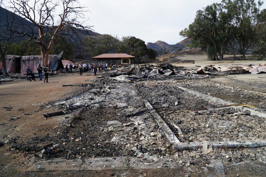
The Santa Monica Mountains Fund, in cooperation with the National Park Service, has launched “The Paramount Project,” a campaign to rebuild Paramount Ranch’s Western Town, recently destroyed by the Woolsey Fire.

The site, long popular with location scouts looking to replicate a rustic town with a Western motif, was also used for many of the special events that take place at Santa Monica Mountains National Recreation Area, including weddings, star parties, music festivals, classic movie nights and a variety of other activities. A National Park Service employee, along with her family, lived in Western Town and was one of three employees who lost park housing in the Woolsey fire.   

The new fundraising initiative is expected to restore the only National Park Service site that interprets American film history. It was purchased by the National Park Service in 1980 and is on the National Register of Historic Places.

DONATE TO “THE PARAMOUNT PROJECT” AT THIS LINK.

The focus of the campaign is to tap into the creativity, expertise, and resources of both the entertainment community and the general public to create a temporary set and then, ultimately, a number of permanent structures that will retain the rustic features of the past, but with more fire-resistant materials.

The National Park Service and the Santa Monica Mountains Fund have already been contacted by members of the entertainment industry who would like to be involved in the project.

In 1927, Paramount Pictures purchased 2,700 acres of the old Rancho Las Virgenes for use as a "movie ranch." Thus began an era of film production that had continued until last week with more than 300 films, television shows and commercials being shot here. The current ranch is comprised of 765 acres.

Famous Hollywood actors, from Bob Hope and Marlene Dietrich to Sandra Bullock and Bradley Cooper, have strolled around the dusty streets that could be magically transformed into a real town that included a general store, a sheriff’s jail, a saloon, drugstore and a variety of other settings. After it was purchased by Paramount Pictures, a veritable who's who of Hollywood, such as director Cecil B. DeMille and actors Gary Cooper and Claudette Colbert, practiced their craft here for the next 25 years.

But it was the diverse landscape that was the real star of the show. It offered filmmakers the freedom to create distant locales such as colonial Massachusetts in The Maid of Salem (1937), ancient China in The Adventures of Marco Polo (1938), a South Seas island in Ebb Tide (1937), and numerous western locations including San Francisco in Wells Fargo (1937). The art of illusion was mastered in this landscape.

In the 1950s, Western Town was created for television shows, such as The Cisco Kid. More recent television productions at Paramount include The Mentalist, Weeds, episodes of the X-Files and Hulu’s Quickdraw.

More recently, Western Town gained attention as Main Street in HBO’s hit series “Westworld.” For five years in the 1990s, it stood in as Colorado Springs, Colorado, providing the backdrop for many of actress Jane Seymour’s frontier adventures on the popular TV show Dr. Quinn, Medicine Woman.  Also, Sandra Bullock had a leading role in The Lake House here.

Less known is the history of the Paramount Racetrack. The track operated from 1956 to 1957 and was known as one of the most challenging in the nation. The movie, The Devil’s Hairpin, was filmed on the course, which closed down after three fatalities within 18 months from its opening. Most of the track still winds through the grass and oak woodlands of the park.

Santa Monica Mountains National Recreation Area (SMMNRA) is the largest urban national park in the country, encompassing more than 150,000 acres of mountains and coastline in Ventura and Los Angeles counties. A unit of the National Park System, it comprises a seamless network of local, state, and federal parks interwoven with private lands and communities. As one of only five Mediterranean ecosystems in the world, SMMNRA preserves the rich biological diversity of more than 450 animal species and 26 distinct plant communities. For more information, visit www.nps.gov/samo.

The Santa Monica Mountains Fund works to protect and encourage appreciation and understanding of the Santa Monica Mountains National Recreation Area. The Fund achieves this by supporting National Park Service efforts in education, science, research, improved facilities, citizen engagement, stewardship and philanthropy. For more information, visit www.samofund.org.

The General Store seen prior to the Woolsey Fire.

The General Store seen prior to the Woolsey Fire.

Photos From Janss Conejo Ranch in 1960-1961 in What is Now Wildwood Park

6274WildwoodMovieRanch7-30-1961WaltDibblee.jpg

In the 1930s to 1960s, a number of TV shows and movies were filmed in what is now Wildwood Park, like Gunsmoke, The Rifleman, Spartacus and Wuthering Heights. Steve Dibblee of Ventura Views has provided these shots taken by his father, Walt Dibblee, of a western ranch town in Wildwood Park in 1960-1961.

You can see the same, familiar Mountclef Ridge in Wildwood Park today

You can see the same, familiar Mountclef Ridge in Wildwood Park today

Steve indicated the above photo shows The Rifleman's house and barn. It may also have been used in "The Man Who Shot Liberty Valance."

Steve indicated the above photo shows The Rifleman's house and barn. It may also have been used in "The Man Who Shot Liberty Valance."

And here is a bit of a depressing scene at the ranch on September 28, 1960.

And here is a bit of a depressing scene at the ranch on September 28, 1960.

View more of Walt's Ventura County area photography, including an extensive collection of aerials from the mid 1950s to the late 1960s, at VenturaViews.com.

Grant Park in Ventura is a No Brainer for Panoramic Views of the Coast

GrantParkView1_0515.jpg

The 107 acre Grant Park is easily accessible from Downtown Ventura via Brakey Road or Summit Drive in Ventura and is a quick and easy way to get your dose of coastal views. There's no playground, restrooms, water or other facilities at this park. But there's plenty of open space and scenery below.

GrantParkView2_0515.jpg

The view looking the opposite direction of the Pacific Ocean, over the western-most section residential section of Ventura.Several other notable items at Grant Park are the privately owned Serra Cross Park and the Ventura Botanical Gardens Demonstration Trail.

You can spend 10 minutes up here for a quick dose of views or you could spend half a day up here resting, hiking, picnicking and enjoying the ocean breezes.

At the very, very top of Grant Park is this lone bench.

At the very, very top of Grant Park is this lone bench.

Visiting Santa Cruz Island, the Largest of the Eight Channel Islands of California

East Santa Cruz Island Scorpion Anchorage, viewed from the Cavern Point trail.

East Santa Cruz Island Scorpion Anchorage, viewed from the Cavern Point trail.

Santa Cruz Island is 22 miles long and ranges from two to six miles wide, making it the largest of the eight Channel Islands at nearly 62,000 acres. It is one of four islands that are located in Santa Barbara County (the others are San Miguel, Santa Cruz and the smallest of the eight islands, Santa Barbara Island).

Californian Channel Islands map en

The island has been occupied for over 9,000 years, including thousands of years by the Chumash Indians. In 1769, the expedition of Don Gaspar de la Portola reached the island. He and two Fathers traveling with him brought a staff with a cross on it, were well received, but realized they left the staff on the island. The Indians realized this and brought the staff to the ship the next day via canoe. The Spanish were so impressed by this that they called the island, the Island of the Holy Cross (Santa Cruz).

After Mexico became independent of Spain in 1821, the island became Mexican owned, then California became a state in 1950 and the island came with it. Sheep were brought to Santa Cruz Island in the 1850s and by 1864, 24,000 sheep grazed on it. Sheep operations continued on the island until the 1980s. Today, the National Park Service owns and operates 24% of Santa Cruz Island as part of Channel Islands National Park.  The remainder of the land is managed by The Nature Conservancy, the University of California Field Station and the Santa Cruz Island Foundation.

Access to the island is primarily through private concessionaire, Island Packers, from the Ventura Harbor and Channel Islands Harbor. The two island destinations open to the public are East Santa Cruz at Scorpion Ranch (also referred to as Scorpion Anchorage) and Mid Santa Cruz at Prisoners Harbor (so named as a result of a short-lived occupation of the area by convicted Mexican prisoners in 1830).

Views of the Scorpion Rock area of Santa Cruz Island

Views of the Scorpion Rock area of Santa Cruz Island

It takes roughly an hour to an hour and a half to get to the island, where activities including hiking, snorkeling, exploring the beach, kayaking and learning about the history of the island. 

Whatever you bring to the island, you must bring back with you. There are no trash receptacles, stores, vending machines, eateries, so be prepared when you visit with food, water, sunscreen, etc. There is also year-round camping available at both locations on Santa Cruz Island, with water available only at the Scorpion Anchorage campground.

Campground at Scorpion Anchorage

Campground at Scorpion Anchorage

Kayaking is of particular interest at Scorpion Anchorage, as you can explore the nearby sea caves. Guided tours are also available from third parties like the Santa Barbara Adventure Company.

Kayaking is quite popular at Santa Cruz Island

Kayaking is quite popular at Santa Cruz Island

We also saw wildlife at Santa Cruz Scorpion Anchorage including an island fox, otters, all sorts of bird and more. The moderately challenging, two mile Cavern Point Loop hike provided magnificent views of the coast.

There is also a small, yet quite informative visitor center where you can really learn a lot about the history of the island. I was shocked actually to learn that to the south of Santa Cruz Island is a 150 million year old sedimentary rock and that the world's largest collection of sea caves populate the volcanic rocks of the north shore of the island. Also, during the last Ice Age, the sea level was lower and the four northern Channel Islands (San Miguel, Santa Cruz, Santa Rosa, Anacapa), were joined as a single island known as Santa Rosae.

This timid island fox swung by our picnic spot at Scorpion Ranch. National Park Service asks the public not to feed the wildlife for a variety of reasons, and we obliged.

This timid island fox swung by our picnic spot at Scorpion Ranch. National Park Service asks the public not to feed the wildlife for a variety of reasons, and we obliged.

Channel Islands National Park is comprised of five of the eight Channel Islands; San Miguel, Santa Rosa, Santa Cruz, Anacapa and Santa Barbara. Learn more about Channel Islands National Park at www.nps.gov/chis. Learn how to get to the islands via Island Packers at islandpackers.com.

Visit the Robert J. Lagomarsino Visitor Center at Channel Islands National Park, located at near Ventura Harbor Village, for a wealth of information, video and displays regarding the Channel Islands.

Conejo Valley Guide Facebook Fans Chime In On Favorite Staycation Options

In a recent drawing on the Conejo Valley Guide Facebook Page, folks were asked to comment on some of their favorite local area "staycation" alternatives this summer.  Here's a compilation of their responses.

LOCAL AREA HIKING AND TRAILS

LOCAL AREA CAMPING

LOCAL AREA BEACHES

Beach Options

  • Surfrider Beach in Malibu
  • Kanan to Malibu, lunch at Malibu Seafood, then El Matador Beach
  • Avila Beach
  • Leo Carrillo Beach
  • Silverstrand Beach
  • Pismo Beach

Hiking

Day Trips and Short Overnight Trips

  • Emerald Iguana Inn in Ojai
  • Solvang and Chumash Casino
  • Visit Malibu, Ventura or Santa Barbara, take a walk and eat seafood by the shore
  • Disneyland
  • Santa Monica Pier / Pacific Park
  • Las Vegas
  • San Diego
  • Laguna Woods
  • Bike riding at Venice boardwalk
  • Universal Studios
  • Palm Springs / Rancho Mirage
  • Santa Barbara Pier - Stearns Wharf
  • Wine tasting in Los Olivos
  • Catalina Island

LOCAL AREA BIKE PATHS

COMMUNITY SWIMMING POOLS

Other Outdoor Activities

Other

  • Stay home but eat dinner out with friends
  • Local area beer and wine tasting
  • Catch a concert at the Canyon Club
  • Drive through Hidden Valley and lunch in Westlake Village
  • The spa at Four Seasons Westlake Village
  • Movie marathon at home
  • Dodger game
  • Westlake Village Inn
  • Stagecoach Inn Museum in Newbury Park
  • Reagan Library
  • Los Angeles Zoo with the kids